
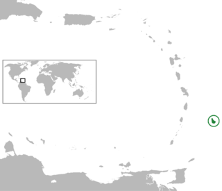
Barbados is an island country in the Lesser Antilles of the West Indies, in the Caribbean region next to North America and north of South America, and is the most easterly of the Caribbean islands. It lies on the boundary of the South American and the Caribbean Plates. Its capital and largest city is Bridgetown.

Bridgetown is the capital and largest city of Barbados. Formerly The Town of Saint Michael, the Greater Bridgetown area is located within the parish of Saint Michael. Bridgetown is sometimes locally referred to as "The City", but the most common reference is simply "Town". As of 2014, its metropolitan population stands at roughly 110,000.

Barbados is a relatively small country with a length of 21 miles (34 km) and a width of 14 miles (23 km). Barbados has 1,600 kilometres (990 mi) of public paved roads, two active marine ports in, remnants of a railway system, and one airport; the Sir Grantley Adams International Airport, located in Christ Church.

The parish of St. Michael is one of eleven parishes of Barbados. It has a land area of 39 km2 (15 sq mi) and is found at the southwest portion of the island. Saint Michael has survived by name as one of the original six parishes created in 1629 by Governor Sir William Tufton.

The country of Barbados is divided into sub-regions known as parishes.

Speightstown, also known as Little Bristol, is the second largest City centre of Barbados. It is situated 12 miles (19 km) north of the capital city of Bridgetown, in the northern parish of Saint Peter.
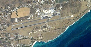
Grantley Adams International Airport (GAIA) is an international airport at Seawell, Christ Church, Barbados, serving as the country's only port of entry by air.
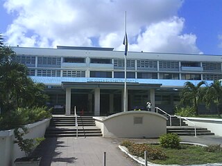
The Queen Elizabeth Hospital (Q.E.H.) is located in Barbados' capital city Bridgetown, which is located in the parish of Saint Michael. The hospital is the main General Hospital for the southern part of the island.
The Parliament of Barbados is the national legislature of Barbados. It is accorded legislative supremacy by Chapter V of the Constitution of Barbados. The Parliament is bicameral in composition and is formally made up of two houses, an appointed Senate and an elected House of Assembly, as well as the President of Barbados who is indirectly elected by both. Both houses sit in separate chambers in the Parliament Buildings, in the national capital Bridgetown in Saint Michael.

The Lloyd Erskine Sandiford Centre is a conference centre facility on the Caribbean island of Barbados. Owned by the government of Barbados and managed by the government agency Barbados Conference Services Limited (BCSL), the Lloyd Erskine Sandiford Centre is just outside the capital city of Bridgetown, in St. Michael.
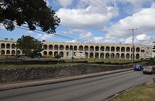
St. Ann's Garrison, or more commonly known as "The Garrison", is a small district located in the country of Barbados. This Garrison Historic Area is situated about 3.2 km (2 mi) south of Heroes Square in the capital-city Bridgetown, and just west of the village of Hastings in the neighbouring parish of Christ Church. It is dominated by its historic horse race-track, located on the 12 ha (30-acre) parade ground called the Garrison Savannah. The Garrison area additionally contains many historic buildings including barracks for military personnel. The district is bisected by Highway 7, with Saint Ann's Fort, where the Barbados Defence Force (BDF) is based, lying to the west.
The following is an alphabetical list of topics related to the nation of Barbados.
The Wildey area of the Parish of Saint Michael located roughly 4 km east of Bridgetown, it lies on the border with the Parish of Christ Church. Normally a very busy area with the ABC Highway, Wildey is one of the main convergence points for vehicles travelling either towards the capital-city Bridgetown or towards points in northern Barbados. In recent years the area was reconfigured for traffic mitigation, the tri-directional split or fork in the highway formerly known as the "Wildey Y" was changed to only allow southbound traffic to turn left or right on to Wildey Road only. Northbound traffic must now travel on Wildey Road to Highway R road which brings traffic back to BET hill.

The Port of Bridgetown, is a seaport in Bridgetown on the southwest coast of Barbados. Situated at the North-Western end of Carlisle Bay, the harbour handles all of the country's international bulk ship-based trade and commerce. In addition to international-shipping the Deep Water Harbour is the port of entry for southern-Caribbean cruise ships. The port is one of three designated ports of entry in Barbados, along with the privately owned Port Saint Charles marina and the Sir Grantley Adams International Airport. The port's time zone is GMT −4, and it handles roughly 700,000 cruise passengers and 900,000 tonnes of containerised cargo per year.
The ABC Highway is the main urban highway in Barbados. Opened in 1989, it is named after three famous Barbadian politicians: John Michael Geoffrey Manningham ("Tom") Adams, Errol Barrow, and Hugh Gordon Cummins. From the east, the highway stretches from the Grantley Adams International Airport in Christ Church, to the western end at Cave Hill Road and University Drive, Cave Hill Campus, University of the West Indies, in Saint Michael. It roughly encircles the Parish of Saint Michael and the wider metropolitan area of Bridgetown.
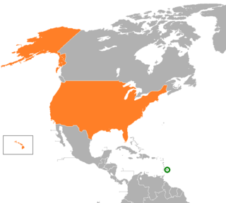
The United States and Barbados have had cordial bilateral relations since Barbados' independence in 1966. The United States has supported the government's efforts to expand the country's economic base and to provide a higher standard of living for its citizens. Barbados is a beneficiary of the U.S. Caribbean Basin Initiative. U.S. assistance is channeled primarily through multilateral agencies such as the Inter-American Development Bank and the World Bank, as well as the U.S. Agency for International Development (USAID) office in Bridgetown.

Relations between Barbados and China began on 4 September 1967 with Barbados recognizing the People's Republic of China from 30 May 1977, just over one decade after the eastern Caribbean island nation's independence from the United Kingdom.
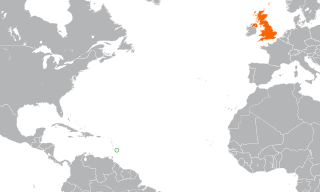
The historical ties between the governments of Barbados and the United Kingdom of Great Britain and Northern Ireland (UK) are long and complex, including settlement, post-colonialism and modern bilateral relations. The two countries are related through common history spanning 339 years (1627–1966). Since the Barbadian date of political independence, these nations continue to share ties through the Commonwealth of Nations. Until becoming a Commonwealth republic in 2021, Barbados also shared the same Head of State, with Queen Elizabeth II as their Monarch.

The Chamberlain Bridge is a bridge in Bridgetown, the capital and largest city of the nation of Barbados. In 1872, it was a swing bridge across the marine inlet channel of the inner basin of the Careenage at Carlisle Bay. The outmoded steel structure was dismantled and rebuilt in 2005–2006 as a lifting bridge with the state-of the-art modern technology of an all-composite single-leaf bascule design. This design is a counterweighted bridge span that pivots upward, permitting pleasure craft to pass through an inlet channel. The bridge was built using fibre-reinforced plastic (FRP), which is lighter, long lasting and non-corrosive.

The Parliament Buildings, is the seat of the Parliament of Barbados. Built between 1870 and 1874, the buildings have been the meeting place for both chambers of Parliament since 16 June 1874, and a former site of Colonial administration of Barbados. It consists of two buildings in the neo-Gothic architectural style, and are reminiscent of the Victorian era of Great Britain.
