Tropospheric scatter is a method of communicating with microwave radio signals over considerable distances – often up to 300 kilometres (190 mi), and further depending on terrain and climate factors. This method of propagation uses the tropospheric scatter phenomenon, where radio waves at UHF and SHF frequencies are randomly scattered as they pass through the upper layers of the troposphere. Radio signals are transmitted in a narrow beam aimed just above the horizon in the direction of the receiver station. As the signals pass through the troposphere, some of the energy is scattered back toward the Earth, allowing the receiver station to pick up the signal.

Radio propagation is the behavior of radio waves as they travel, or are propagated, from one point to another, or into various parts of the atmosphere. As a form of electromagnetic radiation, like light waves, radio waves are affected by the phenomena of reflection, refraction, diffraction, absorption, polarization, and scattering. Understanding the effects of varying conditions on radio propagation has many practical applications, from choosing frequencies for international shortwave broadcasters, to designing reliable mobile telephone systems, to radio navigation, to operation of radar systems.
JJY is the call sign of a low frequency time signal radio station located in Japan.

Duga was a Soviet over-the-horizon radar (OTH) system used as part of the Soviet missile defense early-warning radar network. The system operated from July 1976 to December 1989. Two operational Duga radars were deployed, one near Chernobyl and Chernihiv in the Ukrainian SSR, the other in eastern Siberia.

KRLX is a student-run, freeform radio format, non-commercial FM campus radio station broadcasting from Northfield, Minnesota. Affiliated with Carleton College. The station's call sign was chosen to read "KaRL-ten," since X is the Roman numeral for ten. KRLX broadcasts with 100 watts of power at 88.1 MHz and produces live streaming media, expanding the station's reach to the world. The KRLX studios are located in the basement of the Sayles-Hill Campus Center, Carleton's student union; they feature basic production tools, a record library, and a live FM studio. The basement location is the motivation for the station's motto, "It's better on the bottom." KRLX is licensed for continuous broadcast, but because the station is student-run, the signal is present only when school is in session. Because Carleton does not offer a summer term, the station generally broadcasts September through June, though not during winter and spring breaks.

CBHA-FM is a Canadian radio station. It is the CBC Radio One affiliate in Halifax, Nova Scotia, broadcasting at 90.5 MHz. It is the flagship CBC Radio One station for the Maritime provinces. CBHA's studios are located on 7067 Chebucto Road in Halifax, while its transmitter is located on Washmill Lake Drive in Clayton Park.
KNCO is a Grass Valley, California, Class B radio station operating with 5,000 watts of power from a transmitter site in Grass Valley, California. KNCO is an ABC Radio Network affiliate. It was originally on 1250 kHz and moved to 830 kHz in 1986.

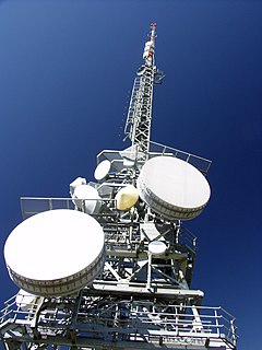
The White Alice Communications System was a United States Air Force telecommunication network with 80 radio stations constructed in Alaska during the Cold War. It used tropospheric scatter for over-the-horizon links and microwave relay for shorter line-of-sight links. Sites were characterized by large parabolic, tropospheric scatter antennas as well as smaller microwave dishes for point to point links.

Columbia Island, is an island in the Long Island Sound and part of New Rochelle, New York. It is situated off the south-eastern coast of Davids' Island, immediately adjacent to Pea Island. The island varies in size from about one acre to 175 square feet depending on the tide.

Microwave transmission is the transmission of information by microwave radio waves. Although an experimental 40-mile (64 km) microwave telecommunication link across the English Channel was demonstrated in 1931, the development of radar in World War II provided the technology for practical exploitation of microwave communication. In the 1950s, large transcontinental microwave relay networks, consisting of chains of repeater stations linked by line-of-sight beams of microwaves were built in Europe and America to relay long distance telephone traffic and television programs between cities. Communication satellites which transferred data between ground stations by microwaves took over much long distance traffic in the 1960s. In recent years, there has been an explosive increase in use of the microwave spectrum by new telecommunication technologies such as wireless networks, and direct-broadcast satellites which broadcast television and radio directly into consumers' homes.

Vintage amateur radio is a subset of amateur radio activity and is considered a form of nostalgia or hobby much like antique car collecting, where enthusiasts collect, restore, preserve, build, and operate amateur radio equipment from bygone years, most notably those using vacuum tube technology.

Friedrichshafen FF.33 was a German single-engined reconnaissance three-bay wing structure biplane, using twin floats, designed by Flugzeugbau Friedrichshafen in 1914 for the Marine-Fliegerabteilung aviation forces of the Kaiserliche Marine.
CILK-FM is a Canadian radio station located in Kelowna, British Columbia. Broadcasting at 101.5 FM, the station airs an adult contemporary format branded as 101.5 EZ Rock. The station is owned by Bell Media.
KMJ is a news/talk radio station located in Fresno, California, owned by Cumulus Media. Its studios are located at the Radio City building on Shaw Avenue in North Fresno and its transmitter is in Orange Cove, California. While 580 kHz is a Regional broadcast frequency, the station broadcasts with 50,000 watts, the highest power for an AM station permitted by the FCC, covering most of Central California. It is that region's primary entry point station in the Emergency Alert System.

CBI is a Canadian radio station. It is the CBC Radio One affiliate in Sydney, Nova Scotia broadcasting at 1140 kHz on the AM dial. The station serves all of Cape Breton Island by operating a network of FM rebroadcasters. It is also simulcast on its sister station, CBIS-FM at 92.1 MHz in Sydney.
The North Atlantic Radio System (NARS) was a chain of five tropospheric scatter communication sites that stretched from Iceland to RAF Fylingdales, forming an extension of the Distant Early Warning Line.

Emley Moor transmitting station is a telecommunications and broadcasting facility on Emley Moor, 1 mile (1.6 km) west of the village centre of Emley, mid-way between the villages of Kirkburton and West Bretton, in turn between Huddersfield and Wakefield, West Yorkshire, England. It is made up of a 1,084-foot-tall (330.4 m) concrete tower and apparatus which began transmitting in 1971. It is protected under UK law as a Grade II listed building. It is the tallest freestanding structure in the United Kingdom, seventh-tallest freestanding structure and fourth-tallest tower in Europe outside Russia, and 24th-tallest tower in the world.

The Abergavenny transmitting station was originally built by the IBA in 1969 as a relay for BBC and ITV VHF 405-line analogue television. It consists of a 46 m guyed lattice mast carrying the aerials at the top. This structure was built on a 440 m hill known as Gilwern Hill overlooking the towns of Gilwern and Abergavenny in Monmouthshire, South Wales. The band III VHF television feeds were provided off-air from St. Hilary and Wenvoe, both near Cardiff.

Olenegorsk Radar Station is the site of a Soviet and Russian early warning radar. It is located near Olenegorsk on the Kola Peninsula, north of the Arctic Circle in north west Russia. It is considered to be a key part of the Russian early warning system against ballistic missile attack, and provides coverage of ballistic missile launches in the Norwegian Sea and North Sea. The station is operated by the Russian Aerospace Defence Forces.