Related Research Articles

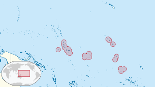
Kiribati, officially the Independent and Sovereign Republic of Kiribati, is an island country in the Micronesia subregion of Oceania in the central Pacific Ocean. Its permanent population is over 119,000 as of the 2020 census, with more than half living on Tarawa atoll. The state comprises 32 atolls and one remote raised coral island, Banaba. Its total land area is 811 km2 (313 sq mi) dispersed over 3,441,810 km2 (1,328,890 sq mi) of ocean.

Kiribati is a full member of the Commonwealth, the IMF and the World Bank, and became a full member of the United Nations in 1999. Kiribati hosted the Thirty-First Pacific Islands Forum in October 2000. Kiribati has Least Developed Country Status and its interests rarely extend beyond the region. Through accession to the Lomé Convention, then Cotonou Agreement, Kiribati is also a member of the African Caribbean and Pacific Group. Kiribati maintains good relations with most countries and has particularly close ties to Pacific neighbours Japan, Australia, South Korea and New Zealand. Kiribati briefly suspended its relations with France in 1995 over that country's decision to renew nuclear testing in the South Pacific.

The Line Islands, Teraina Islands or Equatorial Islands are a chain of 11 atolls and coral islands in the central Pacific Ocean, south of the Hawaiian Islands. Eight of the atolls are parts of Kiribati. The remaining three—Jarvis Island, Kingman Reef, and Palmyra Atoll—are territories of the United States grouped with the United States Minor Outlying Islands. The Line Islands, all of which were formed by volcanic activity, are one of the longest island chains in the world, stretching 2,350 km (1,460 mi) from northwest to southeast. One of them, Starbuck Island, is near the geographic center of the Pacific Ocean. Another, Kiritimati, has the largest land area of any atoll in the world. Only Kiritimati, Tabuaeran, and Teraina have a permanent population. Besides the 11 confirmed atolls and islands, Filippo Reef is shown on some maps, but its existence is doubted.

The Gilbert Islands are a chain of sixteen atolls and coral islands in the Pacific Ocean, about halfway between Papua New Guinea and Hawaii. They constitute the main part of the nation of Kiribati.

Abaiang, also known as Apaiang, Apia, and in the past, Charlotte Island, in the Northern Gilbert Islands, is a coral atoll of Kiribati, located in the west-central Pacific Ocean. Abaiang was the island of the first missionary to arrive in the Gilberts, Hiram Bingham II. Abaiang has a population of 5,872.

Caroline Island is the easternmost of several uninhabited coral atolls comprising the southern Line Islands in the central Pacific Ocean nation of Kiribati.

Tarawa is an atoll and the capital of the Republic of Kiribati, in the Micronesia region of the central Pacific Ocean. It comprises North Tarawa, which has 6,629 inhabitants and much in common with other more remote islands of the Gilbert group, and South Tarawa, which has 56,388 inhabitants as of 2015, half of the country's total population. The atoll was the site of the Battle of Tarawa during World War II.

South Tarawa is the capital and hub of the Republic of Kiribati and home to more than half of Kiribati's population. The South Tarawa population centre consists of all the small islets from Betio in the west to Bonriki and Tanaea in the north-east, connected by the South Tarawa main road, with a population of 63,439 as of 2020.

Aranuka is an atoll of Kiribati, located just north of the equator, in the Gilbert Islands. It has an area of 11.6 square kilometres and a population of 1,057 in 2010. By local tradition, Aranuka is the central island of the Gilbert group.
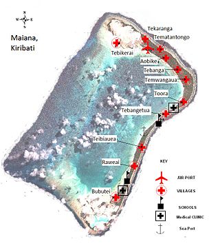
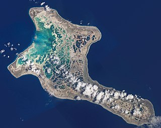
Maiana is an atoll in Kiribati and is one of the Central Gilbert Islands. Maiana is 44 kilometres (27 mi) south of the capital island of South Tarawa and has a population of 1,982 as of 2015. The northern and eastern sides of the atoll are a single island, whilst the western edge consists of submerged reefs and many uninhabited islets, all surrounding a lagoon. The atoll is 14 kilometres (8.7 mi) long and is very narrow, with an average width of less than 1 kilometre (0.62 mi) and a total land area of 16.72 square kilometres (6.46 sq mi).

Nonouti is an atoll and district of Kiribati. The atoll is located in the Southern Gilbert Islands, 38 km north of Tabiteuea, and 250 km south of Tarawa. The atoll is the third largest in the Gilbert Islands and is the island where the Roman Catholic religion was first established in Kiribati, in 1888.
Bikenibeu is a settlement in Kiribati. It is located close to the southeastern corner of the Tarawa atoll, part of the island country of Kiribati. It is part of a nearly continuous chain of settlements along the islands of South Tarawa, which are now linked by causeways. The low-lying atoll is vulnerable to sea level rise. Rapid population growth has caused some environmental problems. Kiribati's main government high school, King George V and Elaine Bernachi School, is located in Bikenibeu, as well as the Ministries of Environment and Education.

Christianity is the predominant religion in Kiribati, with Catholicism being its largest denomination.
Education in Kiribati is free and compulsory from age 6 to 14, which includes primary school through grade six, and Junior Secondary School for three additional grade levels. In 1998, the gross primary enrollment rate was 84.4 percent, and net primary enrollment rate was 70.7 percent. School quality and access to education are better in urban areas; schools in small communities on isolated islands are expensive to maintain. Mission schools are slowly being absorbed into the government primary school system.

Howland Island and Baker Island are two uninhabited U.S. atolls in the Equatorial Pacific that are located close to one another. Both islands are wildlife refuges, the larger of which is Howland Island. They are both part of the larger political territory of the United States Minor Outlying Islands and they are also both part of the larger geographic grouping of the Phoenix Islands. Each is a National Wildlife Refuge managed by a division of Interior, the U.S. Fish and Wildlife Service. On January 6, 2009, U.S. President George W. Bush included both islands to the Pacific Remote Islands Marine National Monument.
Tebua Tarawa was an island of the Republic of Kiribati. It was part of the Tarawa Atoll, which is part of the main chain of islands. It originally was popular with fishermen. In the 1990s, rising seas posed a threat to it. It remained uninhabited when it disappeared in 1999, along with the island Abanuea.
The Tarawa Climate Change Conference (TCCC), was held in the Republic of Kiribati from 9 to 10 November 2010. The purpose of the conference was to support the initiative of the President of Kiribati, Anote Tong, to hold a consultative forum between vulnerable states and their partners with a view of creating an enabling environment for multi-party negotiations under the auspices of the UNFCCC. The conference was the successor event to the Climate Vulnerable Forum held in November 2009 in the Maldives, when eleven climate vulnerable countries signed the Bandos Island declaration pledging to show moral leadership and commence greening their economies by voluntarily committing to achieving carbon neutrality. Based on the lessons learned in the COP process, the TCCC proposed a more inclusive format of consultations, involving key partners among major developed and developing nations.
The COVID-19 pandemic in Kiribati is part of the ongoing worldwide pandemic of coronavirus disease 2019 caused by severe acute respiratory syndrome coronavirus 2. The virus was confirmed to have reached Kiribati on 18 May 2021.

The Coral reefs of Kiribati consists of 32 atolls and one raised coral island, Banaba, which is an isolated island between Nauru and the Gilbert Islands. The islands of Kiribati are dispersed over 3.5 million km2 (1.4 million sq mi) of the Pacific Ocean and straddle the equator and the 180th meridian, extending into the eastern and western hemispheres, as well as the northern and southern hemispheres. 21 of the 33 islands are inhabited. The groups of islands of Kiribati are:
Protected areas of Kiribati include marine protected areas managed by the Environment and Conservation Division, of the Kiribati Ministry of Environment, Lands and Agricultural Development. Kiribati, in partnership with the New England Aquarium and Conservation International (CI), manages the Phoenix Islands Protected Area (PIPA), which is a World Heritage Site that was established in 2006, and is the second largest of the world's marine protected areas. The U.S. administered Pacific Remote Islands Marine National Monument is currently the world's largest designated marine protected area (MPA), and is to the north and north-east of the PIPA.
References
- ↑ "Kiribati: How Real is the Possibility of Relocating an Entire Country? | The Basement Geographer". basementgeographer.com. Archived from the original on 2016-06-03. Retrieved 2016-05-24.
- ↑ "Islands disappear under rising seas". BBC. 1999-06-14. Retrieved 2016-05-24.
- ↑ Vidal, John (25 November 2005). "Pacific Atlantis: first climate change refugees". The Guardian . Archived from the original on 15 January 2024.
Two uninhabited Kiribati islands, Tebua Tarawa and Abanuea, disappeared underwater in 1999, according to the South Pacific regional environment programme.
- ↑ Stephenson, Marcus L. (2023). Routledge Handbook on Tourism and Small Island States in the Pacific. Routledge. p. 269. doi:10.4324/9780429019968-22. ISBN 9781032323909.
According to South Pacific Regional Environment Programme, two small, uninhabited Kiribati islets, Tebua Tarawa and Abanuea, disappeared underwater in 1999 (Kirby 1999).
| | This Kiribati location article is a stub. You can help Wikipedia by expanding it. |