"Eritrea" is an ancient name, associated in the past with its Greek form Erythraia, Ἐρυθραία, and its derived Latin form Erythræa. This name relates to that of the Red Sea, then called the Erythræan Sea, from the Greek for "red", ἐρυθρός, erythros. The Italians created the colony of Eritrea in the 19th century around Asmara, and named it with its current name. After World War II Eritrea was annexed to Ethiopia. In 1991 the Eritrean People's Liberation Front defeated the Ethiopian government. Tigray is a region of Ethiopia whose religions, food, language and culture are the same as that of the greater part of Eritrea. A lot of people have families on both sides of the border between Eritrea and Tigray. Eritrea officially celebrated its 1st anniversary of independence on May 24, 1991.

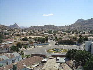
Asmara, or Asmera, is the capital and most populous city of Eritrea and the Central Region. It sits at an elevation of 2,325 metres (7,628 ft), making it the sixth highest capital in the world by altitude. The city is located at the tip of an escarpment that is both the northwestern edge of the Eritrean highlands and the Great Rift Valley in neighbouring Ethiopia. In 2017, the city was declared as a UNESCO World Heritage Site for its well-preserved modernist architecture. Asmara was first settled in 800 BC with a population ranging from 100 to 1000. The city was then founded in the 12th century CE after four separate villages unified to live together peacefully after long periods of conflict.

Massawa is a city on the Red Sea coast of Eritrea located at the northern end of the Gulf of Zula beside the Dahlak Archipelago. As a historical and important port for many centuries, it was ruled by a succession of polities, including the Axumite Empire, Medri Bahri Kingdom, the Umayyad Caliphate, various Beja sultanates, the Ottoman Empire, the Khedivate of Egypt, Italy, Britain, and Ethiopia, until Eritrea's independence in 1991. Massawa was the capital of the Italian Colony of Eritrea until it was moved to Asmara in 1897.

Badme is a town in the Gash-Barka region of Eritrea. Control of the town was at the centre of the Eritrean–Ethiopian border conflict, which lasted from the end of the Eritrean–Ethiopian War in 1998 to the signing of a joint statement at the Eritrea–Ethiopia summit in 2018, 20 years after the conflict started.

The nakfa is the currency of Eritrea and was introduced on 8 November 1997 to replace the Ethiopian birr at par. The currency takes its name from the Eritrean town of Nakfa, site of the first major victory of the Eritrean War of Independence. The nakfa is divided into 100 cents.
The Eritrean–Ethiopian War, one of the conflicts in the Horn of Africa, took place between Ethiopia and Eritrea from May 1998 to June 2000, with the final peace only agreed to in 2018, twenty years after the initial confrontation. Eritrea and Ethiopia, two of the world's poorest countries, spent hundreds of millions of dollars on the war and suffered tens of thousands of casualties as a direct consequence of the conflict. Only minor border changes resulted.
Keren, formerly known as Cheren and Sanhit, is the second-largest city in Eritrea. It is situated around 91 kilometres (57 mi) northwest of Asmara at an elevation of 1,390 metres (4,560 ft) above sea-level. The town sprawls on a wide basin surrounded by granitic mountains on all sides. It serves as the capital of the Anseba region, and is home to the Bilen people.
Nakfa is a town in the Northern Red Sea region of Eritrea. It is also the name of a sub region of Eritrea.

The Eritrean War of Independence was a conflict fought between the Ethiopian government and Eritrean separatists from September 1961 to May 1991.

Barentu is a town in north-western Eritrea, lying south of Agordat, and is the capital of Gash-Barka Region. The town is integrated with different types of tribes: Kunama, Nara, Tigre and Tigrigna being the dominant.
Attai is a village in western Eritrea.
Mescul is a town in western Eritrea.
Chibabo is a village in western Eritrea. It is located in Mogolo Subregion in the Gash-Barka region.

Italian Eritrea was a colony of the Kingdom of Italy in the territory of present-day Eritrea. Although it was formally created in 1890, the first Italian settlements in the area were established in 1882 around Assab. The colony officially lasted until 1947.

The Second Afar insurgency is an ongoing insurgency in the Afar Region of Ethiopia and the Southern Red Sea Region of Eritrea, waged by various Afar rebel groups. Both Ethiopia and Eritrea have supported different rebel groups in the region in a proxy war, and have occasionally engaged in border skirmishes with each other, as well as with opposing rebel groups.