Abraham's Bay

Last updated
Abraham's Bay
Town
Bahamas location map.svg
Red pog.svg
Abraham's Bay
Coordinates: 22°22′30″N72°57′44″W / 22.37500°N 72.96222°W / 22.37500; -72.96222
CountryFlag of the Bahamas.svg  Bahamas
Island Mayaguana
Government
  MayorThomas Dawson
Population
 (2010)
  Total143
Time zone UTC-5 (Eastern Time Zone)
Area code 242

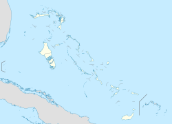
Abraham's Bay (named after Abraham Charlton) is a town in the Bahamas. It is located on the south side of Mayaguana island and has a population of 143.(2010 Census) [1]

Contents

Notable places

Notable places include: [2]

Related Research Articles

<span class="mw-page-title-main">The Bahamas</span> Country in North America

The Bahamas, officially the Commonwealth of The Bahamas, is a country in North America. It is an island country within the Lucayan Archipelago of the West Indies in the Atlantic Ocean. It contains 97% of the Lucayan Archipelago's land area and 88% of its population. The archipelagic state consists of more than 3,000 islands, cays, and islets in the Atlantic Ocean, and is located north of Cuba and northwest of the island of Hispaniola and the Turks and Caicos Islands, southeast of the U.S. state of Florida, and east of the Florida Keys. The capital is Nassau on the island of New Providence. The Royal Bahamas Defence Force describes The Bahamas' territory as encompassing 470,000 km2 (180,000 sq mi) of ocean space.

<span class="mw-page-title-main">Nassau, Bahamas</span> Capital and largest city of The Bahamas

Nassau is the capital and largest city of The Bahamas. It is located on the island of New Providence, which had a population of 246,329 in 2010, or just over 70% of the entire population of The Bahamas. As of April 2023, the preliminary results of the 2022 census of the Bahamas reported a population of 296,522 for New Providence, 74.26% of the country's population. Nassau is commonly defined as a primate city, dwarfing all other towns in the country. It is the centre of commerce, education, law, administration, and media of the country.

This article talks about transportation in the Bahamas, a North American archipelagic state in the Atlantic Ocean.

<span class="mw-page-title-main">Rayville, Louisiana</span> Town in Louisiana, United States

Rayville is a town in and the parish seat of Richland Parish in northeastern Louisiana, United States. The population, which is 69 percent African American, was 4,234 at the 2000 census, but it had declined by nearly 13 percent in 2010 to 3,695.

<span class="mw-page-title-main">Charlton, Massachusetts</span> Town in Massachusetts, United States

Charlton is a town in Worcester County, Massachusetts, United States. The population was 13,315 at the 2020 census.

<span class="mw-page-title-main">Dudley, Massachusetts</span> Town in Massachusetts, United States

Dudley is a town in Worcester County, Massachusetts, United States. The population was 11,921 at the 2020 census.

<span class="mw-page-title-main">Andros, Bahamas</span> Archipelago of The Bahamas

Andros Island is an archipelago within The Bahamas, the largest of the Bahamian Islands. Politically considered a single island, Andros in total has an area greater than all the other 700 Bahamian islands combined. The land area of Andros consists of hundreds of small islets and cays connected by mangrove estuaries and tidal swamplands, together with three major islands: North Andros, Mangrove Cay, and South Andros. The three main islands are separated by bights, estuaries that trifurcate the island from east to west. It is 167 kilometres (104 mi) long by 64 km (40 mi) wide at the widest point.

<span class="mw-page-title-main">Local government in the Bahamas</span> Overview of Bahamian local governments

Local government in The Bahamas exists at two levels: 32 districts and 41 towns. The boundaries of districts are defined by the First Schedule of The Bahamas Local Government Act 1996, defined with reference to parliamentary constituency boundaries. The Second Schedule lists 13 districts which are divided into town areas. Towns are governed by directly elected town committees. Second Schedule districts are governed by nine-person district councils composed of the chairs of the town committees, and if numerically required, additional people elected by the town committees. The 19 Third Schedule districts are unitary authorities which cannot be divided into towns. They are governed by nine-person district councils which are directly elected by voters. The powers of Second Schedule and Third Schedule councils are slightly different, and the Third Schedule district known as the City of Freeport has a slightly different list of enumerated powers.

<span class="mw-page-title-main">Cat Island, Bahamas</span> Island District in The Bahamas

Cat Island is located in central Bahamas, and is one of its districts. Cat Island also has the nation's highest point, Mount Alvernia. It rises to 63 metres (207 ft) and is topped by a monastery called The Hermitage. This assembly of buildings was erected by the Franciscan "Brother Jerome".

<span class="mw-page-title-main">Exuma</span> Place in Bahamas

Exuma is a district of The Bahamas, consisting of over 365 islands and cays.

<span class="mw-page-title-main">Mayaguana</span> Island and district in The Bahamas

Mayaguana is the easternmost island and district of The Bahamas. Its population was 277 in the 2010 census. It has an area of about 280 km2 (110 sq mi).

<span class="mw-page-title-main">Ragged Island, Bahamas</span> Island in Bahamas

Ragged Island is a 23 km2 (8.9 sq mi) island and district in the southern Bahamas. Ragged Island is part of the Jumentos Cays and Ragged Island Chain. The crescent-shaped chain measures over 180 km (110 mi) in length and includes cays known as Raccoon Cay, Hog Cay and Double-Breasted Cay. Island ownership is stated to have been granted to William George Lockhart some time in the 18th century. On 8 September 2017, Duncan Town took a direct hit from Hurricane Irma.

Kemp's Bay is a town on the island of Andros in the Bahamas and, before 1996, was also a district of the Bahamas.

The majority of the population of the Turks and Caicos Islands are Christian. They include Protestant 72.8%, Baptists 35.8%, Church of God 11.7%, Roman Catholics 11.4%, Anglicans 10%, Methodists 9.3%, Seventh-Day Adventists 6%, Jehovah's Witnesses 1.8%, and Other 14%

<span class="mw-page-title-main">North Andros</span> District of The Bahamas

North Andros is one of the 31 districts of the Bahamas. It is also the largest district in the country. It has some of the largest settlements on Andros Island and many churches as well. The population is 4,069.

Carmanville is a Canadian community in the province of Newfoundland and Labrador.

<span class="mw-page-title-main">Index of the Bahamas–related articles</span>

The following is an alphabetical list of topics related to the Commonwealth of The Bahamas.

<span class="mw-page-title-main">Chief Councillor</span>

A Chief Councilor is the highest position within a District Council of the Bahamas. As provided within the Bahamas Local Government Act, the Chief Councillor is the representative of the council for all purposes. His or her tenure in office begins from the very day of election until the expiration of the term as prescribed by their respective District Council or if they so wish to resign.

<span class="mw-page-title-main">Southbridge, Massachusetts</span> Town in Massachusetts, United States

Southbridge is a city in Worcester County, Massachusetts, United States. The population was 17,740 at the 2020 census. Although Southbridge has a city form of government, it is legally known as the Town of Southbridge.

References

  1. MAYAGUANA POPULATION BY SETTLEMENT AND TOTAL NUMBER OF OCCUPIED DWELLINGS: 2010 CENSUS - Bahamas Department of Statistics
  2. "Abraham's Bay Town Square". bahamasgeotourism.