Abtu, Afghanistan | |
|---|---|
 Abtu, Afghanistan Location in Afghanistan | |
| Coordinates: 34°52′N67°31′E / 34.867°N 67.517°E | |
| Country | |
| Province | Bamyan Province |
| Time zone | + 4.30 |
Abtu is a village in Bamyan Province in northern-central Afghanistan. [1]
Abtu, Afghanistan | |
|---|---|
| Abtu, Afghanistan Location in Afghanistan | |
| Coordinates: 34°52′N67°31′E / 34.867°N 67.517°E | |
| Country | |
| Province | Bamyan Province |
| Time zone | + 4.30 |
Abtu is a village in Bamyan Province in northern-central Afghanistan. [1]

Bamyan Province also spelled Bamiyan, Bāmīān or Bāmyān is one of the thirty-four provinces of Afghanistan with the city of Bamyan as its center, located in central parts of Afghanistan.

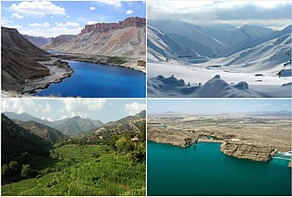
Bamyan also spelled Bamiyan or Bamian is the capital of Bamyan Province in central Afghanistan. Its population of approximately 70,000 people makes it the largest city in Hazarajat. Bamyan is at an altitude of about 8,366 feet (2,550 m) above sea level. The Bamyan Airport is located in the middle of the city. The driving distance between Bamyan and Kabul in the southeast is approximately 180 kilometres (110 mi). The Band-e-Amir National Park is to the west, about a half-hour drive from the city of Bamyan.

The Buddhas of Bamiyan were two 6th-century monumental statues carved into the side of a cliff in the Bamyan valley of central Afghanistan, 130 kilometres (81 mi) northwest of Kabul at an elevation of 2,500 metres (8,200 ft). Carbon dating of the structural components of the Buddhas has determined that the smaller 38 m (125 ft) "Eastern Buddha" was built around 570 CE, and the larger 55 m (180 ft) "Western Buddha" was built around 618 CE, which would date both to the time when the Hephthalites ruled the region. On orders from Taliban founder Mullah Omar, the statues were destroyed in March 2001, after the Taliban government declared that they were idols. International and local opinion strongly condemned the destruction of the Buddhas.
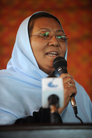
Dr. Habiba Sarābi is a hematologist, politician, and reformer of the reconstruction of Afghanistan after the Taliban first took power. In 2005, she was appointed as Governor of Bamyan Province - the first Afghan woman to become a provincial governor. She had served as Afghanistan's Minister of Women's Affairs and as Minister of Culture and Education. Sarabi was instrumental in promoting women's rights and representation and environmental issues. She belongs to the ethnic Hazara people of Afghanistan. Her last name is sometimes spelled Sarobi.

The Hajigak Pass is a mountain pass of Afghanistan. It is situated at a height of 3,700 metres (12,100 ft) above sea-level in the northern part of Maidan Wardak province, connecting it with Bamyan province to the northwest. It is one of the two main routes from Kabul to Bamyan in Hazarajat, leading across the Koh-i-Baba range.
Kahmard District is a district of Bamyan province in central Afghanistan. The District Capital is Kahmard. It is located at an altitude of 1,475 meters, with a population of 31,042 as of 2003. Kahmard is situated 140 km from Bamiyan city, in the north of the province, and is divided into five valleys.
Sayghan District, also spelt Saighan, Seyghan and other variant spellings, and also known as Saraik or Sarayek, and other variant spellings of this name, is an administrative district of Bamyan province, Afghanistan.
Shibar, is a district located in the western end of the Bamyan province in Afghanistan. It is in a mountainous region. The main village Shibar is at 2,637 m altitude on the all-seasons secondary road from Bamyan to Kabul through the Shibar Pass.
Yakawlang is district located in the northwestern part of Bamyan Province. Its population is 76,897 (2011) predominantly from the Hazara ethnic group. The capital city Yakawlang formerly held 60,000 residents, and it was destroyed by Taliban forces in 2001. Massacres of civilians by the Taliban were reported by Human Rights groups.
There is a gravel surfaced airport near the city.

Shibar Pass in Afghanistan is situated at a height of 3,000 metres (9,800 ft) above sea-level, connecting Parwan Province with Bamyan Province. It is the longer of the two main routes from Kabul to Bamiyan. The journey is approximately 6 and half hours long covering around 237 km (147 mi). It was originally designed and built by Ahmad Shah Shairzay and a German engineer between 1933 and 1938. It is noted to be an important mountain pass of the country.
Bamyan is a district of Bamyan province in Afghanistan. In 2003, the population was put at 70,028, of which the majority group is Hazara while the Tajik is a minority group. New Zealand peace keepers operate in the district as well as most of Bamyan Province.
Daizangi, also spelled as Dai Zangi,, is one of the major tribes of the Hazaras of Hazarajat in central Afghanistan. They inhabit the Bamyan, Yakawlang, Panjab and Waras districts of Bamyan Province, the Shahristan in Daikundi Province, and Lal Wa Sarjangal in Ghor Province. The 19th-century Hazara Mir Elkhani, Mir Naser Beg, Mir Azeem Beg was the mir of the Daizangi who led the final battle of the Hazaras against Abdur Rahman in the battle of Uruzgan. He was exiled to Bokhara in present-day Uzbekistan, where he wrote his memoirs "Yad e Guzishta", Memories of the past. The Daizangi sub-tribes include the Bubali, Gedi, Kamyaba, Kut-daghi, Khushamadi, Kirigu, Miramur, Qaraqul Daghi, Sag Deh, Sag Jui, Sag-Pae, Sehpai, Takana, Takash, Urarus, and Yangur.
`Ambar Samuch is a village in Bamyan District of Bamyan Province in northern-central Afghanistan.
Bamyan Airport, officially named Shahid Mazari Airport, is located in the city of Bamyan, which is the capital of Bamyan Province in Afghanistan. It is a domestic airport under the country's Ministry of Transport and Civil Aviation (MoTCA), and serves the population of Bamyan Province. Security in and around the airport is provided by the Afghan National Security Forces.

Chaghcharan Airport is located in the eastern section of Chaghcharan, which is the capital of Ghor Province in Afghanistan. It is a domestic airport under the country's Ministry of Transport and Civil Aviation (MoTCA), and serves the population of Ghor and nearby provinces. Security in and around the airport is provided by the Afghan National Security Forces.
Tourism in Afghanistan is regulated by the Ministry of Information and Culture. There are at least 350 tourism companies operating in Afghanistan. Tourism was at its peak before the 1978 Saur Revolution, which was followed by the decades of war. Between 2013 and 2016, Afghan embassies issued between 15,000 and 20,000 tourist visas annually.
The Kunduz River is a tributary of the Amu Darya in northern Afghanistan. It rises in Bamyan Province in the Hindu Kush, and in its upper reaches is also known as the Bamyan River or the Surkhab River. After passing through Baghlan Province and Kunduz Province, the Kunduz River merges into the Amu Darya.
The Enlightenment Movement or Junbesh-e Roshnayi is a grassroots civil disobedience movement of Hazaras created in 2016 in Afghanistan in response to the Afghan government's change in routing plans for proposed international electricity networking, which was perceived as continuing historical anti-Hazara discrimination. The group organised major protests in Afghanistan and internationally during 2016 and 2017, protesting against discrimination. The group's youthful leadership challenged traditional Hazara leaders for representativity of the community.
Dara-i Sufi Bala District is a district in Samangan Province, Afghanistan. It was created in 2005 from Darah Sof District.
| | This Bamyan Province, Afghanistan location article is a stub. You can help Wikipedia by expanding it. |