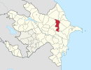
Coordinates: 40°31′42″N48°44′30″E / 40.52833°N 48.74167°E
A geographic coordinate system is a coordinate system that enables every location on Earth to be specified by a set of numbers, letters or symbols. The coordinates are often chosen such that one of the numbers represents a vertical position and two or three of the numbers represent a horizontal position; alternatively, a geographic position may be expressed in a combined three-dimensional Cartesian vector. A common choice of coordinates is latitude, longitude and elevation. To specify a location on a plane requires a map projection.
Acıdərə | |
---|---|
Coordinates: 40°31′42″N48°44′30″E / 40.52833°N 48.74167°E | |
Country | |
Rayon | Shamakhi |
Municipality | Göylər |
Population (2014) | |
• Total | 1 |
Time zone | AZT (UTC+4) |
• Summer (DST) | AZT (UTC+5) |
Acıdərə (also, Adzhidere and Akhzhidara) is a village in the Shamakhi Rayon of Azerbaijan. The village forms part of the municipality of Göylər. [1] According to Azerbaijan's State Statistics Committee, only one person lived in the village as of 2014. [2]
Azerbaijan, officially the Republic of Azerbaijan, is a country in the South Caucasus region of Eurasia at the crossroads of Eastern Europe and Western Asia. It is bounded by the Caspian Sea to the east, Russia to the north, Georgia to the northwest, Armenia to the west and Iran to the south. The exclave of Nakhchivan is bounded by Armenia to the north and east, Iran to the south and west, and has an 11 km long border with Turkey in the northwest.
Göylər is a village and the most populous municipality, except for the capital Şamaxı, in the Shamakhi Rayon of Azerbaijan. It has a population of 6,844. The municipality consists of the villages of Göylər Dağ, Göylər Çöl, Acıdərə, and Yenikənd.
The State Statistics Committee of Azerbaijan Republic is a governmental agency within the Cabinet of Azerbaijan in charge of collection, processing and disseminating statistical data on the economy, demographics and other sectors of activity in Azerbaijan Republic. The agency is headed by Arif Valiyev.
Leroy No. 339, Saskatchewan is a rural municipality in central Saskatchewan, east of Saskatoon. Leroy No. 339 started out with the name Roach from January 1, 1913 until March 14, 1914 when the name changed to Ayr. Ayr remained the name after 1914 through until February 27, 1931 when it became Leroy No. 339.
Úhořilka is a small village in the Havlíčkův Brod District, Vysočina Region of the Czech Republic. 51 people live in Úhořilka and it has 2,52 km². It was first documented in 1454.
Pirəqanım is a village in the Ismailli Rayon of Azerbaijan. The village forms part of the municipality of Müdrəsə. According to Azerbaijan's State Statistics Committee, only two people lived in the village as of 2014.
Dahar is a village in the Ismailli Rayon of Azerbaijan. The village forms part of the municipality of Cülyan. According to Azerbaijan's State Statistics Committee, only five people lived in the village as of 2014.
Kənzə is a village in the Ismailli Rayon of Azerbaijan. The village forms part of the municipality of Qoşakənd. According to Azerbaijan's State Statistics Committee, only three people lived in the village as of 2014.
Damlamaca is a former village in the Gobustan Rayon of Azerbaijan. The village formed part of the municipality of Cəmcəmli.
Şıxlar is a former village in the Gobustan Rayon of Azerbaijan. The village formed part of the municipality of Xilmilli.
Gədik is a former village in the Quba Rayon of Azerbaijan. The village formed part of the municipality of Gədikqışlaq.
İbrahimhapıt is a former village in the Quba Rayon of Azerbaijan.
Əlməkolu is a village in the Siazan Rayon of Azerbaijan. The village forms part of the municipality of Dağ Quşçu. According to Azerbaijan's State Statistics Committee, only four people lived in the village as of 2014.
Dəmirli is a village in the Tartar Rayon of Azerbaijan.
Qars is a former village in the Khizi Rayon of Azerbaijan. The village formed part of the municipality of Tıxlı.
Quzumkənd is a village in the Martuni Province of the de facto Republic of Artsakh, de jure part of the Republic of Azerbaijan.
Mingə is a village in the Ismailli Rayon of Azerbaijan. The village forms part of the municipality of Keyvəndi. The area is renowned for excessive bush and dryness, due to being situated on one of the two highest peaks of Azerbaijan.
Yuxarı Əngilan is a former village in the Khizi Rayon of Azerbaijan.
Gryzów is a village in the administrative district of Gmina Jedlińsk, within Radom County, Masovian Voivodeship, in east-central Poland. It lies approximately 5 kilometres (3 mi) west of Jedlińsk, 17 km (11 mi) north-west of Radom, and 77 km (48 mi) south of Warsaw.
Novoqolovka is a former village in the municipality of Uzuntəpə in the Jalilabad Rayon of Azerbaijan.
Balıqçı is a former village in the municipality of Qazıməmməd in the Hajigabul District of Azerbaijan.
Meyniman is a village in the municipality of Birinci Meyniman in the Hajigabul Rayon of Azerbaijan. In 2014, it was listed as an abandoned village.
Musa is a village in the municipality of Aşağı Astanlı in the Yardymli Rayon of Azerbaijan. According to Azerbaijan's State Statistics Committee, only eight people lived in the village as of 2014.
This Shamakhi Rayon location article is a stub. You can help Wikipedia by expanding it. |