
The Chesapeake Bay is the largest estuary in the United States. The Bay is located in the Mid-Atlantic region and is primarily separated from the Atlantic Ocean by the Delmarva Peninsula, including parts of the Eastern Shore of Maryland, the Eastern Shore of Virginia, and the state of Delaware. The mouth of the Bay at its southern point is located between Cape Henry and Cape Charles. With its northern portion in Maryland and the southern part in Virginia, the Chesapeake Bay is a very important feature for the ecology and economy of those two states, as well as others surrounding within its watershed. More than 150 major rivers and streams flow into the Bay's 64,299-square-mile (166,534 km2) drainage basin, which covers parts of six states and all of Washington, D.C.

Saxis is a town in Accomack County, Virginia, United States. The population was 241 at the 2010 census.

Suffolk is an independent city in Virginia, United States. As of 2020, the population was 94,324. It is the 10th-most populous city in Virginia, the largest city in Virginia by boundary land area as well as the 14th-largest in the country. Suffolk is located in the Hampton Roads metropolitan area. This also includes the independent cities of Chesapeake, Hampton, Newport News, Norfolk, Portsmouth, and Virginia Beach, and smaller cities, counties, and towns of Hampton Roads. With miles of waterfront property on the Nansemond and James rivers, present-day Suffolk was formed in 1974 after consolidating with Nansemond County and the towns of Holland and Whaleyville. The current mayor is Mike Duman.
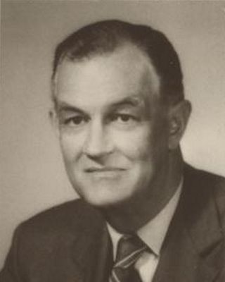
Mills Edwin Godwin Jr. was an American politician who was the 60th and 62nd governor of Virginia for two non-consecutive terms, from 1966 to 1970 and from 1974 to 1978.

The James River Bridge (JRB) is a four-lane divided highway lift bridge across the James River in the Commonwealth of Virginia. Owned and operated by the Virginia Department of Transportation, it carries U.S. Route 17 (US 17), US 258, and State Route 32 across the river near its mouth at Hampton Roads. The bridge connects Newport News on the Virginia Peninsula with Isle of Wight County in the South Hampton Roads region, and is the easternmost such crossing without a tunnel component.
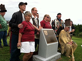
The area around Suffolk, Virginia, which is now an independent city in the Hampton Roads region in the southeastern part of the state, was originally inhabited by Native Americans. At the time of European contact, the Nansemond people lived along the river later known by the same name. The area was first explored by Jamestown colonists led by explorer John Smith soon after the settlements founding in 1607, seeking means to survive the inhospitable environment at Jamestown Island.

State Route 10 is a primary state highway in the U.S. state of Virginia. The state highway runs 93.58 miles (150.60 km) from U.S. Route 360 in Richmond east to SR 337 in Suffolk. SR 10 is a major suburban highway through Chesterfield County between the Southside of Richmond and Hopewell. Between Hopewell and Smithfield, which is served by SR 10 Business, the state highway passes through rural Prince George, Surry, and Isle of Wight counties, following the route of an old stagecoach road through an area that features many of the preserved James River plantations. SR 10 runs concurrently with US 258 and SR 32 between Smithfield and Suffolk.
Amedeo Obici was an Italian-born American businessman and philanthropist who founded Planters.

Chippokes State Park is a Virginia state park on the south side of the James River on the Captain John Smith Chesapeake National Historic Trail. In addition to forests and fossil hunting on the beach, it includes three historic houses as well as an open-air agricultural and forestry museum with seasonally appropriate events. Other recreational facilities include a visitor center, swimming pool, hiking trails, cabins, yurts and campgrounds). It is located at 695 Chippokes Park Road, in rural Surry County, Virginia off Route 10.
The Nansemond are the Indigenous people of the Nansemond River, a 20-mile-long tributary of the James River in Virginia. Nansemond people lived in settlements on both sides of the Nansemond River where they fished, harvested oysters, hunted, and farmed in fertile soil. Today, Nansemond people belong to the federally recognized Nansemond Indian Nation.

U.S. Route 17 (US 17) is a part of the United States Numbered Highway System that runs from Punta Gorda, Florida, to Winchester, Virginia. In Virginia, the U.S. Highway runs 255.83 miles (411.72 km) from the North Carolina state line in Chesapeake north to its northern terminus at US 11, US 50, and US 522 in Winchester. US 17 is a major highway in the eastern half of Virginia. The U.S. Highway connects the Albemarle Region of North Carolina with the Hampton Roads metropolitan area. Within the urban area, US 17 passes through the South Hampton Roads cities of Chesapeake, Portsmouth, and Suffolk and the Virginia Peninsula city of Newport News. Between Yorktown and Fredericksburg, the U.S. Highway serves as the primary highway of the Middle Peninsula. At Fredericksburg, US 17 leaves the Atlantic Plain; the highway passes through the Piedmont town of Warrenton and crosses the Blue Ridge Mountains on its way to Winchester in the Shenandoah Valley. The route from Tappahannock to Winchester roughly follows the Confederate march during the Civil War to Gettysburg.
Hobson is in the independent city of Suffolk, Virginia, United States. It is located along State Route 628 southwest of U.S. Route 17, on the neck between Chuckatuck Creek and the Nansemond River.

Bennett Creek or Bennett's Creek is a 7.3-mile-long (11.7 km) tributary of the Nansemond River in Suffolk, Virginia.
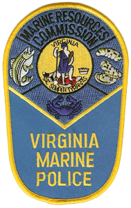
The Virginia Marine Police is the law enforcement division of the Virginia Marine Resources Commission, an agency of the Commonwealth of Virginia, United States.
Pocomoke Sound is a bay of the Chesapeake Bay that forms part of the boundary between the Eastern Shores of Maryland and Virginia. The Pocomoke River is the largest stream feeding into the Sound, which is bounded by Somerset County, Maryland on the north, Worcester County, Maryland, Accomack County, Virginia, and Beasley Bay on the east, the Chesapeake Bay on the south, and Tangier Sound on the west. Its southwesternmost point may be considered to be Watts Island, Virginia.
The 21st Connecticut Infantry Regiment was an infantry regiment that served in the Union Army during the American Civil War.

USS Smith Briggs was a Union Army gunboat destroyed during the American Civil War.
The Suminoe oyster, is a species of true oyster which inhabits intertidal hard grounds and substrate, as well as muddy creeks of warm estuaries throughout the western Pacific. It is large and flat in appearance and almost identical in gross morphology to Crassostrea virginica.
Bevans Oyster Company is an oyster farm and seafood aquaculture company headquartered in Westmoreland County, Virginia. The company has been described as one of the largest oyster companies in the State of Virginia.


