Related Research Articles

Ahr is a river in Germany, a left tributary of the Rhine. Its source is at an elevation of approximately 470 metres (1,540 ft) above sea level in Blankenheim in the Eifel, in the cellar of a timber-frame house near the castle of Blankenheim. After 18 kilometres (11 mi) it crosses from North Rhine-Westphalia into Rhineland-Palatinate.
The Wied is a river in Rhineland-Palatinate, Germany, and a right tributary of the Rhine.

The Aar is a 50-kilometre-long (31 mi) river in western Germany, left tributary of the Lahn. It rises in the Taunus mountains, near Taunusstein. It flows generally north through the towns Taunusstein, Bad Schwalbach, Aarbergen and Hahnstätten. It flows into the Lahn in Diez.
The Klingbach is a stream, just under 38 kilometres (24 mi) long, in South Palatinate, Germany, and a left-hand tributary of the Michelsbach.

The Otterbach is a stream, 42 kilometres long, in South Palatinate in the German state of Rhineland-Palatinate, that flows eastwards and northeastwards towards the Upper Rhine.

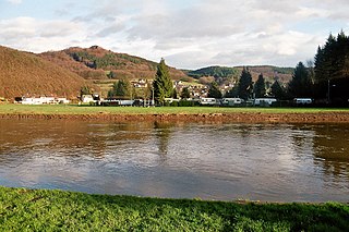
The Ahr valley is named after the Ahr, a left tributary of the Rhine in Germany. It begins at the Ahr spring (Ahrquelle) in Blankenheim in the county of Euskirchen and runs generally eastwards. At its southernmost point it enters the county of Ahrweiler, and hence the state of Rhineland-Palatinate. Running through the collective municipality of Adenau the valley bends northeast at its confluence with the Adenauer Bach and reaches the collective municipality of Altenahr, from where it resumes its characteristic west to east course, albeit interrupted by meanders. Here begins the section that is known as the Ahr valley (Ahrtal) in a touristic sense. Here it is characterized by vineyards on the south-facing slopes and a picturesque rocky landscape, carved out by the river creating a 300 metre deep gorge in the Ahr Hills. In the next stage the Ahr reaches the area of the county town of Bad Neuenahr-Ahrweiler, before finally discharging into the Rhine south of Remagen in the borough of Sinzig.

The Dernbach is a river in the district of Südliche Weinstraße in the German state of Rhineland-Palatinate. It is 7.46 kilometres long and forms the left-hand, northern headstream of the Eisbach.

The Hainbach, historically also called the Heimbach, in its lower reaches also called the Wooggraben and Krebsbächel, is a river, overt 33 kilometres long, and a right tributary of the Speyerbach in the German state of Rhineland-Palatinate.
The Eußerbach forms the right, northwestern headstream, over 11 kilometres long, of the Eisbach river in the county of Südliche Weinstraße, in the German federal state of Rhineland-Palatinate.

The Riveris is an orographically right-hand, southern tributary of the River Ruwer in the German state of Rhineland-Palatinate. It was impounded in 1953 by the Riveris Dam which inter alia supplies water to the town of Trier. The name Riveris is derived from the Latin and means "little river".
The Seltenbach is a 5.3-kilometre-long (3.3 mi) stream and an orographically right-hand tributary of the Eisbach in the northeastern part of the Palatine Forest in the German state of Rhineland-Palatinate.
The Weidas, also called the Weidasserbach, is a roughly eleven-kilometre-long, orographically right-hand tributary of the Selz in the German region of Rhenish Hesse.

The Little Kyll German: Kleine Kyll, pronounced: "kill") is a 23.9-kilometre-long (14.9 mi) orographically right-hand tributary of the Lieser.

The Teufelsley is a hill, 495.9 m above sea level (NHN), in the East Eifel, a region of the Eifel mountains in Germany. It is located near Liers in the county of Ahrweiler in the state of Rhineland-Palatinate and consists of the largest contiguous quartzite block in Europe.

The Enz is a 37.9-kilometre-long (23.5 mi), orographically right-hand tributary of the Prüm in the Eifel mountains of Germany.
The Alfbach is a 22.3-kilometre-long (13.9 mi), orographically right-bank tributary of the Prüm in the county of Bitburg-Prüm in the German state of Rhineland-Palatinate.
The Odenbach is a 22.7-kilometre-long (14.1 mi) orographically right bank tributary of the Glan in the counties of Kaiserslautern and Kusel in the German state of Rhineland-Palatinate.

The Mehrbach is a river, 23-kilometre-long (14 mi) long, and a tributary of the Wied. Its GKZ is 27164, its catchment has an area of 65.868 km2 (25.432 sq mi).

The Brexbach is a river, just under 22 kilometres (14 mi) long, and an orographically left-hand tributary of the Saynbach in the German state of Rhineland-Palatinate.

Brohlbach is a river of Rhineland-Palatinate, Germany. It is a left tributary of the Rhine at Brohl-Lützing.
References
- 1 2 3 4 5 Geoexplorer of the Rhineland-Palatinate Water Authority (Wasserwirtschaftsverwaltung Rheinland-Pfalz) (retrieved 8 November 2013)
- ↑ Landscape fact file (landscape area) of the Landscape Information System of the Rhineland-Palatinate Nature Conservation Office (Naturschutzverwaltung Rheinland-Pfalz)