
France began colonizing the Americas in the 16th century and continued into the following centuries as it established a colonial empire in the Western Hemisphere. France established colonies in much of eastern North America, on several Caribbean islands, and in South America. Most colonies were developed to export products such as fish, rice, sugar, and furs.

New Orleans is a consolidated city-parish located along the Mississippi River in the southeastern region of the U.S. state of Louisiana. With a population of 383,997 according to the 2020 U.S. census, it is the most populous city in Louisiana, third most populous city in the Deep South, and the twelfth-most populous city in the southeastern United States. Serving as a major port, New Orleans is considered an economic and commercial hub for the broader Gulf Coast region of the United States. New Orleans is also a region of French Louisiana, along with the Cajun Country.

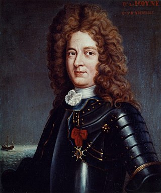
The French Quarter, also known as the Vieux Carré, is the oldest neighborhood in the city of New Orleans. After New Orleans was founded in 1718 by Jean-Baptiste Le Moyne de Bienville, the city developed around the Vieux Carré, a central square. The district is more commonly called the French Quarter today, or simply "The Quarter", related to changes in the city with American immigration after the 1803 Louisiana Purchase. Most of the extant historic buildings were constructed either in the late 18th century, during the city's period of Spanish rule, or were built during the first half of the 19th century, after U.S. purchase and statehood.
Pierre Le Moyne d'Iberville or Sieur d'Iberville was a French soldier, explorer, colonial administrator, and trader. He is noted for founding the colony of Louisiana in New France. He was born in Montreal to French colonist parents.

Tremé is a neighborhood in New Orleans, Louisiana. "Tremé" is often rendered as Treme, and the neighborhood is sometimes called by its more formal French name, Faubourg Tremé; it is listed in the New Orleans City Planning Districts as Tremé / Lafitte when including the Lafitte Projects.

Jean-Baptiste Le Moyne de Bienville, also known as Sieur de Bienville, was a French colonial administrator in New France. Born in Montreal, he was an early governor of French Louisiana, appointed four separate times during 1701–1743. He was the younger brother of explorer Pierre Le Moyne d'Iberville.

The history of New Orleans, Louisiana, traces the city's development from its founding by the French in 1718 through its period of Spanish control, then briefly back to French rule before being acquired by the United States in the Louisiana Purchase in 1803. During the War of 1812, the last major battle was the Battle of New Orleans in 1815. Throughout the 19th century, New Orleans was the largest port in the Southern United States, exporting most of the nation's cotton output and other farm products to Western Europe and New England. As the largest city in the South at the start of the Civil War (1861–1865), it was an early target for capture by Union forces. With its rich and unique cultural and architectural heritage, New Orleans remains a major destination for live music, tourism, conventions, and sporting events and annual Mardi Gras celebrations. After the significant destruction and loss of life resulting from Hurricane Katrina in 2005, the city would bounce back and rebuild in the ensuing years.

Louisiana or French Louisiana was an administrative district of New France. In 1682 French explorer René-Robert Cavelier, Sieur de la Salle erected a cross near the mouth of the Mississippi River and claimed the whole of the drainage basin of the Mississippi River in the name of King Louis XIV, naming it "Louisiana". This land area stretched from the Great Lakes to the Gulf of Mexico and from the Appalachian Mountains to the Rocky Mountains. The area was under French control from 1682 to 1762 and 1801 (nominally) to 1803.

Uptown is a section of New Orleans, Louisiana, United States, on the east bank of the Mississippi River, encompassing a number of neighborhoods between the French Quarter and the Jefferson Parish line. It remains an area of mixed residential and small commercial properties, with a wealth of 19th-century architecture. It includes part or all of Uptown New Orleans Historic District, which is listed on the National Register of Historic Places.
The German Coast was a region of early Louisiana settlement located above New Orleans, and on the west bank of the Mississippi River. Specifically, from east to west, in St. Charles, St. John the Baptist, and St. James parishes of present-day Acadiana. It was largely settled by German immigrants and the four settlements of Augsburg, Hoffen, Karlstein, and Marienthal were located along this "coast".

The Old Mobile Site was the location of the French settlement La Mobile and the associated Fort Louis de La Louisiane, in the French colony of New France in North America, from 1702 until 1712. The site is located in Le Moyne, Alabama, on the Mobile River in the Mobile-Tensaw River Delta. The settlement served as the capital of French Louisiana from 1702 until 1711, when the capital was relocated to the site of present-day Mobile, Alabama. The settlement was founded and originally governed by Pierre Le Moyne d'Iberville. Upon the death of d'Iberville, the settlement was governed by his younger brother, Jean-Baptiste Le Moyne de Bienville. The site can be considered a French counterpart to the English colonial settlement at Jamestown, Virginia. The settlement site and fort were listed on the National Register of Historic Places on May 6, 1976. The Old Mobile Site was determined eligible for designation as a National Historic Landmark on January 3, 2001.

Fort Charlotte, Mobile is a partially-reconstructed 18th-century fort in Mobile, Alabama.

Fort Maurepas, later known as Old Biloxi, was developed in colonial French Louisiana in April 1699 along the Gulf of Mexico . Fort Maurepas was designated temporarily as the capital of Louisiana in 1699. The capital was moved from Biloxi to Mobile in 1710, then to New Orleans in 1723 on the Mississippi River. Government buildings in the latter city were still under construction.

St. Augustine Church is a Catholic parish in New Orleans. Established by free people of color, who also bought pews for slaves, it is said to be the oldest Black Catholic parish in the United States, established in 1841. It was one of the first 26 sites designated on the state's Louisiana African American Heritage Trail.
Fort De La Boulaye Site, also known as Fort Mississippi, is the site of a fort built by the French in south Louisiana in 1699–1700, to support their claim of the Mississippi River and valley. Native Americans forced the French to vacate the fort by 1707.
English Turn is a bend in the Mississippi River in New Orleans, Louisiana.

Faubourg St. John, is a neighborhood in New Orleans, Louisiana, located just north of Broad Street at the intersection of Orleans Avenue. Faubourg St. John is approximately 75 city blocks in area and has an average elevation of about one foot above sea level. It was built along what is known as the Esplanade Ridge. The Esplanade Ridge Historic District was added to the National Register of Historic Places in 1980.
Charles Frederic d'Arensbourg (1693–1777), born Karl Friedrich von Arensburg, was an early leader in the settlement of the German Coast region of Louisiana.
Pierre le Blond de la Tour (1673–1723/4) was an engineer in French Louisiana who was largely responsible for the layout of early New Orleans. He is credited with performing the first work to improve navigability on an American inland river, and also the first work on constructing levees on the Lower Mississippi River.
The French Louisianians, also known as Louisiana French, are Latin French people native to the states that were established out of French Louisiana. They are commonly referred to as French Creoles. Today, the most famous Louisiana French groups are the Alabama Creoles, Louisiana Creoles, and the Missouri French.

