Related Research Articles

Kiribati, officially the Republic of Kiribati, is an independent island nation in the central Pacific Ocean. The permanent population is over 119,000 (2020), more than half of whom live on Tarawa atoll. The state comprises 32 atolls and one raised coral island, Banaba. There is a total land area of 811 square kilometres dispersed over 3.5 million km2 (1.4 million sq mi) of ocean.

Kiribati consists of 32 atolls and one island scattered over all four hemispheres in an expanse of ocean equivalent in size to the contiguous United States. The islands lie roughly halfway between Hawaii and Australia in the Micronesian and Polynesian regions of the South Pacific. The three main island groupings are the Gilbert Islands, Phoenix Islands, and Line Islands. On 1 January 1995 Kiribati moved the International Date Line to include its easternmost islands and make it the same day throughout the country.
The following article outlines transport in Kiribati.
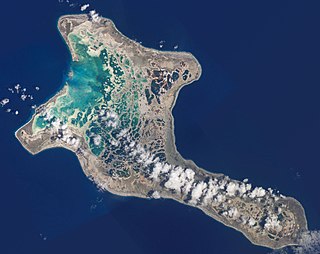
Kiritimati is a Pacific Ocean atoll in the northern Line Islands. It is part of the Republic of Kiribati. The name is derived from the English word "Christmas" written in Gilbertese according to its phonology, in which the combination ti is pronounced s, giving [kiˈrɪsmæs].
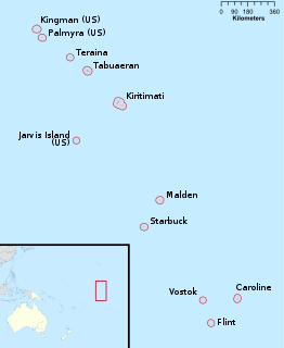
The Line Islands, Teraina Islands or Equatorial Islands are a chain of 11 atolls and coral islands in the central Pacific Ocean, south of the Hawaiian Islands. The island chain stretches northwest to southeast across 2,350 kilometres, making it one of the longest island chains in the world. One of the islands in the group, Kiritimati, has the largest land area of any atoll in the world. Of the 11 islands, all of which were formed by volcanic activity, only the Kiritimati and Tabuaeran atolls and Teraina Island have a permanent population. Eight of the islands are part of Kiribati. The remaining three—Kingman Reef, Palmyra Island and Jarvis Island—are United States territories grouped with the United States Minor Outlying Islands.

Tabuaeran, also known as Fanning Island, is an atoll that is part of the Line Islands of the central Pacific Ocean and part of Kiribati. The land area is 33.73 square kilometres, and the population in 2015 was 2,315. The maximum elevation is about 3 m (10 ft) above high tide.

Air Kiribati is the flag carrier of the Republic of Kiribati and operates scheduled passenger services to 20 atolls spread over an area of 3.5m sq km.
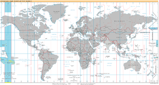
UTC−10:00 is an identifier for a time offset from UTC of −10:00. This time is used in Hawaii, Alaska, French Polynesia, and the Cook Islands.
London is the main settlement on the atoll of Kiritimati belonging to Kiribati in the Pacific Ocean. As of 2005 it has a population of 1,829 people, making it the second largest village on Kiritimati and in the whole Line Islands. In the 2010 census the population was 1,879. Only Tabwakea is slightly larger.

Poland is one of four villages on the island of Kiritimati, Kiribati. The village was named by Emmanuel Rougier after the birth country of his Polish plantation manager and engineer Stanisław Pełczyński, who aided the villagers. He solved the problem of effectively watering palm trees during the dry season by suggesting a modified irrigation system, then helping to build it, and teaching how to use it.
Amalgamated Telecom Holdings Kiribati Limited is the sole communications provider to the Republic of Kiribati. Before a change of ownership, the company was known as Telecom Services Kiribati Limited or short TSKL. In addition to traditional telecommunication, ATHKL offers such services as telegram and facsimile services. Until 2007 the company maintained the country's ccTLD, .ki, which is now under the control of a separate agency, Telecommunications Authority of Kiribati.
Cassidy International Airport is an airport located north of Banana, a settlement on Kiritimati island in Kiribati. Until 2018, it was the only airport in the Kiribati part of the Line Islands with an IATA or ICAO code.
Paris is an abandoned settlement on Kiritimati Island in Kiribati. It is one of three settlements on the island to be named after European places, along with nearby London and Poland.
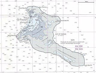
The Bay of Wrecks is a large bay which extends along the northeast coast of Kiritimati Island in Kiribati from Banana to Aeon Point. It is so named as it was a notable hazard to shipping, especially during the 19th century.
Banana is a settlement on Kiritimati Island in Kiribati. It is located to the north of the island close to Cassidy International Airport. It is the third largest village on the island with a population of 1,208 people in 2015.
Vaskess Bay is a large bay which extends along the southwest coast of Kiritimati Island in Kiribati.
Tabwakea is a settlement in Kiribati. It is located on the island of Kiritimati. In 2005 it had a population of 1,881 people. In 2010 it had a population of 2,311, 3,001 in 2015, and 3,537 in 2020. It is the largest village on Kiritimati and in the whole Line Islands.

The Central Polynesian tropical moist forests is a tropical and subtropical moist broadleaf forests ecoregion in Polynesia. It includes the northern group of the Cook Islands, the Line Islands in Kiribati, and Johnston Atoll, Jarvis Island, Palmyra Atoll, and Kingman Reef which are possessions of the United States.
The Church of Jesus Christ of Latter-day Saints in Kiribati refers to The Church of Jesus Christ of Latter-day Saints and its members in Kiribati. In 1976 the first branch was organized in Tarawa. As of 2019, there were 20,946 members in 37 congregations, making it the largest body of LDS Church members in Micronesia. Kiribati also has the most LDS Church members per capita in Micronesia, and the third most members per capita of any country in the world, behind Tonga and Samoa.
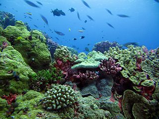
The Coral reefs of Kiribati consists of 32 atolls and one raised coral island, Banaba, which is an isolated island between Nauru and the Gilbert Islands. The islands of Kiribati are dispersed over 3.5 million km2 (1.4 million sq mi) of the Pacific Ocean and straddle the equator and the 180th meridian, extending into the eastern and western hemispheres, as well as the northern and southern hemispheres. 21 of the 33 islands are inhabited. The groups of islands of Kiribati are:
References
- ↑ "20. Kiritimati" (PDF). Office of Te Beretitent - Republic of Kiribati Island Report Series. 2012. Retrieved 28 April 2015.
Coordinates: 1°45′32″N157°10′23″W / 1.759°N 157.173°W
 | This Kiribati location article is a stub. You can help Wikipedia by expanding it. |