
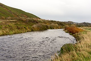
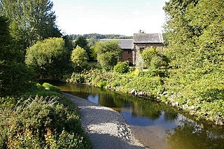
Afon Annell (River Annell) is a small river in Carmarthenshire, Wales.
It is a tributary of the Afon Cothi. [1]
Some of the waters of the Annell were previously diverted via aqueduct to serve the Roman gold mine at Dolaucothi. [2]
Afon Annell (River Annell) is a small river in Carmarthenshire, Wales.
It is a tributary of the Afon Cothi. [1]
Some of the waters of the Annell were previously diverted via aqueduct to serve the Roman gold mine at Dolaucothi. [2]

The River Towy is one of the longest rivers flowing entirely within Wales. Its total length is 120 km (75 mi). It is noted for its sea trout and salmon fishing.
The River Ystwyth is a river in Ceredigion, Wales. The length of the main river is 20.5 miles (33.0 km). Its catchment area covers 75 square miles (190 km2). Its source is a number of streams that include the Afon Diliw, located on the west slopes of Plynlimon on the border of Ceredigion and Powys in the Cambrian Mountains. The Ystwyth flows westwards before its confluence with the Afon Rheidol and the estuary at Aberystwyth to drain into Cardigan Bay.

The Desert of Wales, or Green Desert of Wales, is a large area in central Wales, so called because of its lack of roads and towns and its inaccessibility. The term was invented by English travel writers in the nineteenth century and has no equivalent in the Welsh language. The area corresponds roughly to the upland area called Elenydd in Welsh and also referred to locally as the Cambrian Mountains.
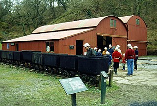
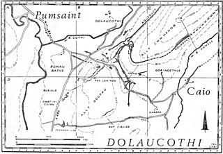
The Dolaucothi Gold Mines, also known as the Ogofau Gold Mine, are ancient Roman surface and underground mines located in the valley of the River Cothi, near Pumsaint, Carmarthenshire, Wales. The gold mines are located within the Dolaucothi Estate which is now owned by the National Trust.

Pumsaint is a village in Carmarthenshire, Wales, halfway between Llanwrda and Lampeter on the A482 in the valley of the Afon Cothi. It forms part of the extensive estate of Dolaucothi, which is owned by the National Trust.
The Afon Cothi is the largest tributary of the River Tywi in south Wales. It is noted for its trout and sea trout (sewin) fishing and for its scenery.

Sarn Helen refers to several stretches of Roman road in Wales. The 160-mile (260 km) route, which follows a meandering course through central Wales, connects Aberconwy in the north with Carmarthen in the west. Despite its length, academic debate continues as to the precise course of the Roman road. Many sections are now used by the modern road network while other parts are still traceable. However, there are sizeable stretches that have been lost and are unidentifiable.

Caio or Caeo is a village in the county of Carmarthenshire, south-west Wales, sited near to the Dolaucothi Gold Mines.
Luentinum or Loventium was a fort and mining settlement in the Roman province of Britannia. It was associated with the Dolaucothi Gold Mines and its remains lie beneath the adjoining village of Pumsaint in the Welsh county of Carmarthenshire. It lay between similar forts at Llandovery and Bremia near Llanio, and some distance away from the fort at Llandeilo. The Roman road Sarn Helen linked Luentinum with Llanio and Llandovery.

The Afon Mynach is a small river in Ceredigion, Wales.
The River Cwmnantcol is a river in North Wales.

Cynwyl Gaeo is a parish and community located in rural Carmarthenshire, Wales, near the boundary with Ceredigion, in the upper Cothi valley about halfway between Lampeter and Llandovery. The population of the village at the United Kingdom Census 2011 was 940. It includes the villages of Caeo, Crug-y-bar, Cwrtycadno, Ffarmers and Pumsaint.

The Afon Dulas, or North Dulas, is a river forming the border between Merionethshire/Gwynedd and Montgomeryshire/Powys in Wales. Another river called Afon Dulas joins the Dyfi from the south, upstream of its confluence with the North Dulas: locally this is referred to as the South Dulas.
The River Brenig is a tributary river of the River Teifi and runs through the market town of Tregaron in Ceredigion, Wales. It is formed from the confluence of the Afon Groes and Afon Berwyn in the foothills of the Cambrian Mountains.
Afon Tanat is a river in northern Powys, Wales. Its source is close to the Cyrniau Nod mountain, to the north of Lake Vyrnwy. The river flows in a generally east-south-east direction until it joins the River Vyrnwy near Llansantffraid-ym-Mechain. For a short distance prior to its confluence it flows within western Shropshire, England.

The Afon Twrch is a short river in Carmarthenshire, West Wales. It joins the River Cothi at the village of Pumsaint, near to which are the Roman gold mines of Dolaucothi.

The Afon Marlais is a right-bank tributary of the Afon Cothi in Carmarthenshire, West Wales. It rises on the slopes of Mynydd Llanfihangel-rhos-y-corn and Mynydd Tre-beddau and flows south-eastwards through Brechfa Forest before reaching the village of Brechfa. After a further kilometre it joins the Cothi immediately downstream of Pont Ynys-Brechfa.

The Dolaucothi Estate is situated about 1 mile (1.6 km) north-west of the village of Caio up the picturesque Cothi Valley in the community of Cynwyl Gaeo, Carmarthenshire, Wales. Its name of Dolaucothi means ‘the meadows of the Cothi’.
Mynydd Mallaen is an expansive plateau to the northwest of Cilycwm in northeast Carmarthenshire, Wales. It forms part of the Cambrian Mountains massif, and is north-west of the Black Mountain (range) in the Brecon Beacons. It takes the form of an undulating plateau with steep slopes dropping away to the Towy valley to the east and those of the Gwenffrwd, Nant Melyn and Afon Cothi to the north and west. Its highest point of 1516 feet or 462m at OS grid reference SN 723455 is surmounted by two Bronze Age cairns known as Crugiau Merched. Caeo Forest covers much of the southern flanks of the hill and smaller forests also cover its eastern slopes. Much of the native woodland consists of sessile oak groves, especially on the valley sides. The human population is very low, being restricted to hill farms engaged in sheep farming, and some holiday cottages.

Salem is a small Welsh village in Ceredigion, located between the Afon Stewi and Nant Seilo rivers. The closest village is Penrhyn-coch.
Coordinates: 52°00′09″N3°58′30″W / 52.00250°N 3.97500°W
| | This Carmarthenshire location article is a stub. You can help Wikipedia by expanding it. |