
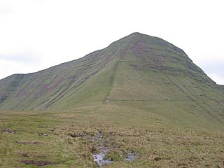
The Black Mountain is a mountain range in South, Mid and West Wales, straddling the county boundary between Carmarthenshire and Powys and forming the westernmost range of the Brecon Beacons National Park. Its highest point is Fan Brycheiniog at 802 metres or 2,631 ft. The Black Mountain also forms a part of the Fforest Fawr Geopark.

The River Cynon in South Wales is a main tributary of the Taff. Its source is the rising of Llygad Cynon at 219 m (719 ft) above sea level at Penderyn, Rhondda Cynon Taf and flows roughly southeast, into the Taff at Abercynon in the same district. The water emerging at Llygad Cynon has been traced back to the sink of the Nant Cadlan at Ogof Fawr.
Cribyn is a mountain in the Brecon Beacons with an elevation of 2608 feet about 300 feet lower than the neighbouring peaks of Pen y Fan and Corn Du. It is a prominent peak in the long and impressive escarpment facing north and running roughly east–west of the central section of the Brecon Beacons.

The Beacons Way is a waymarked long distance footpath in the Brecon Beacons National Park, Wales. It is a linear route which runs for 99 miles (159 km) east to west through the National Park, and passes many of the most important landmarks and mountain peaks in the mountain range. It also includes a few of the towns in the park as well as popular attractions such as Carreg Cennen Castle near Llandeilo at the western end of the path.
The Afon Pyrddin is a river forming a short section of the boundary between the counties of Brecknockshire and Glamorgan in Wales, United Kingdom. It also forms a part of the boundary of the Brecon Beacons National Park, and the boundary of the unitary authorities of Powys and Neath Port Talbot. The river and its waterfalls are one of the key attractions of the Fforest Fawr Geopark designated in 2005.
The Nant Llech is a minor river in Powys, Wales and which lies wholly within the Brecon Beacons National Park. The name means 'slab stream', presumably in reference to the sandstones across which it runs. Its headwater streams, the Nant Llech Pellaf and the Nant Llech Isaf join forces at Blaen Llech and then continue westwards as the Nant Llech for 3 km / 2 mi to a confluence with the River Tawe just east of the village of Abercraf.

The River Giedd is a principal tributary of the River Tawe, Wales. The river runs within the county of Powys and lies almost wholly within the Brecon Beacons National Park.
The Nant Gwys is a river flowing off the Black Mountain in Powys, Wales. Its tributaries Gwys Fawr and the Gwys Fach flow south from Banwen Gwyn and Bwlch y Ddeuwynt respectively and join forces to form the Nant Gwys proper which then flows for about 5 km / 3 mi to its confluence with the Afon Twrch at Cwm-twrch-Uchaf.

The Afon Senni is a river in Powys, Wales which rises in the Fforest Fawr section of the Brecon Beacons National Park and flows northwards for 11 kilometres (7 mi) to a confluence with the River Usk at Sennybridge.
The Caerfanell is a river which rises in the central section of the Brecon Beacons National Park in Powys, Wales. It rises as Blaen Caerfanell on the plateau of Gwaun Cerrig Llwydion and drops steeply down south-eastwards into the head of Glyn Collwn before turning east then north-east into Talybont Reservoir. It emerges from the hydro turbine beneath the dam just above the village of Aber and continues northwards to its confluence with the River Usk at the hamlet of Llansantffraed.

The Afon Sawdde is a river in the county of Carmarthenshire, Wales. For most of its course it flows through the Brecon Beacons National Park and Fforest Fawr Geopark.

Tair Carn Uchaf is a hill in the Brecon Beacons National Park in the county of Carmarthenshire, Wales. Its summit sits atop a plateau-like ridge at 482 metres (1,580 ft) above sea level and is marked by one of the three huge cairns which give the mountain its name.

The Rhiangoll is a river in the Brecon Beacons National Park in Powys, Wales. It rises on the western slopes of Waun Fach, highest point of the Black Mountains and drops steeply down to the west into the north–south valley through which the A479 runs between Talgarth and the hamlet of Tretower and through the village of Cwmdu. It is joined by various minor tributary streams on its left bank including the Ffinnant, Nant yr Ychen, Nant-y-fedw and Nantygarreg, all of which rise on the flanks of the ridge extending between the Pen Trumau spur of Waun Fach and Pen Gloch-y-pibwr. Two tributary streams flowing from Mynydd Troed and Mynydd Llangorse enter on its right bank as does Nant Ewyn east of the village of Bwlch.
The Afon Llynfi is a short river in the county of Powys, south Wales. A tributary of the River Wye, it runs approximately south to north just to the west of the Black Mountains and partly within the Brecon Beacons National Park.
The Afon Hydfer is a short river in Powys in the west of the Brecon Beacons National Park, south Wales. Its headwaters rise on the northeastern slopes of the Black Mountain as the streams named Trinant, Nant y Cadno, Nant yr Erydr and Crognant, joining to flow down Cwm yr Afon on the western edge of Glasfynydd Forest. The river turns east at Blaenau Uchaf, then northeast through Cwm Hydfer and joins the River Usk just below Pont ar Hydfer. Other tributaries of the Hydfer include the streams of Nant Cil-y-clawdd, Nant Crinog and Nant Meity.
The Nant Brân is a short river which rises on the southern slopes of Mynydd Epynt in Powys, Wales. The word 'brân' means 'crow' in Welsh: the name may therefore allude to the dark colour of its waters.
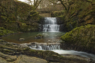
Waterfall Country is an English name often given to the Vale of Neath in South Wales. The tourist area around the head of the valley has an unusually large number of publicly accessible waterfalls. The area is not officially defined but generally includes the group of falls on the Nedd Fechan, Pyrddin, Hepste and Mellte rivers, all of which lie between the villages of Pontneddfechan and Ystradfellte in the Brecon Beacons National Park.

Llanfrynach is a village and community in the county of Powys, Wales, and the historic county of Brecknockshire. The population of the community as taken at the 2011 census was 571. It lies just to the southeast of Brecon in the Brecon Beacons National Park. The village sits astride the Nant Menasgin, a right bank tributary of the River Usk. The B4558 passes just to its north and the Monmouthshire and Brecon Canal also passes around the village. The Welsh name signifies the 'church of Brynach'. The community includes the hamlets of Llanhamlach and Groesffordd.
The Afon Sychryd is a river in Rhondda Cynon Taf, Wales. Although it is a relatively short river, with a total length of 3 miles (5 km), it is notable for the gorge and two waterfalls through which it flows.
The Nant Menasgin is a short river in Powys, Wales whose headwaters rise in Cwm Oergwm, beneath Fan y Bîg, in the central Brecon Beacons, and flow northeastwards via Llanfrynach, to join the River Usk at Pencelli.
