The surface of the river is usually frozen from early November to mid-May, but safe circulation on the ice generally occurs generally from mid-November to the end of April.
Geography
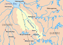
The main hydrographic slopes adjacent to the Again River are:
The Again River originates at the mouth of Lake Mine (length: 3.4 kilometres (2.1mi), elevation: 267 metres (876ft)) in the eastern part of the Cochrane District.
The source of the Again River is located at:
10.4 kilometres (6.5mi) at the east of the Ontario border;
92.5 kilometres (57.5mi) at the south of the mouth of the Again River;
37.6 kilometres (23.4mi) east of Kesagami Lake (Ontario);
From its source, the Again River runs more or less parallel to the Ontario border on 119.9 kilometres (74.5mi) in the following segments:
16.0 kilometres (9.9mi) to the north through three lakes, northeasterly through two lakes including Lake Favell (Ontario) and eastward up to a branch line (from the south- East) which drains the cross-border area between Quebec and Ontario;
55.0 kilometres (34.2mi) to the boundary between Quebec and Ontario;
46.3 kilometres (28.8mi) to the north in Quebec more or less along the interprovincial boundary and in a marsh area, until the cut between the boundary between Quebec and Ontario;
2.6 kilometres (1.6mi) to the north-west in the Cochrane District in Ontario in the marsh area to the mouth.[2]
The Again River flows into the southwestern shore of the Harricana River in front of Low Shoal Island. This confluence is located at:
31.0 kilometres (19.3mi) at southeast of the mouth of the Harricana River;
2.6 kilometres (1.6mi) at west of the boundary between Quebec and Ontario;
88.6 kilometres (55.1mi) at south of the center of the village of Moosonee in Ontario.
Toponymy
The hydronyme "rivière Again" was formalized on December 5, 1968, by the Commission de toponymie du Québec, at the creation of this commission.[3]
History
The river remained largely unexplored until 2012, when Canadian Adam Shoalts successfully canoed the entire length, discovering canyons and notably numerous previously unknown waterfalls.[4][5][6] According to Shoalts in his book Alone Against the North, the name originates from a 1931 surveyor notebook. The surveyor, named King, had been questioning a local Indian trapper about the river, who did not speak English very well, and he kept repeating a word that sounded like "again". Shoalts also said it was believed the river followed a seam that joined Precambrian shield rock with Late Devonian rock.
Map all coordinates usingOpenStreetMapDownload coordinates asKML
This page is based on this Wikipedia article Text is available under the CC BY-SA 4.0 license; additional terms may apply. Images, videos and audio are available under their respective licenses.