Kesagami Lake

Last updated

Kesagami Lake
Orange sunset on Kesagami Lake.jpg
Canada Ontario relief location map.jpg
Red pog.svg
Kesagami Lake
Location Ontario
Coordinates 50°22′30″N80°14′24″W / 50.375°N 80.240°W / 50.375; -80.240 Coordinates: 50°22′30″N80°14′24″W / 50.375°N 80.240°W / 50.375; -80.240
Primary inflows Kesagami River
Primary outflows Kesagami River
Basin  countries Canada
Max. length37 km (23 mi) [1]
Max. width11 km (7 mi) [1]
Surface area207.80 km2 (80.23 sq mi) [2]
Average depth2 m (6 ft 7 in) [2]
Max. depth6 m (20 ft) [2]
Islands 6

Kesagami Lake is a lake of Cochrane District, in Northeastern Ontario, in Canada. [3] It is a shallow lake that was formed assumedly by glacial erosion and unique for its size in the James Bay area. [2] Entirely protected within Kesagami Provincial Park, it is notable in particular for its trophy pike and walleye fishing. [4]

Contents

The lake, formerly also called Mesackamee or Mesackamy Lake, was home to a Hudson's Bay Company trading post, called Mesackamee House, [2] between 1777 and 1780. George Atkinson, Peter Liske, William Thomas, and William Robinson were sent there from Moose Factory along with two indigenous families to settle the area in order to protect business at Abitibi from competitors. The post was abandoned by October 1779. [5]

Fish species in Kesagami Lake include burbot, herring, northern pike, common white sucker and longnose sucker, perch, walleye, and lake whitefish.

Description

The lake is irregularly shaped with some long and large bays; from its wide open northern portion three large bays stretch off to the south, including Opimiskau Bay, [6] which measures about 8.0 by 6.4 kilometres (5 by 4 mi), and Newnham Bay, [7] that is 37 kilometres (23 mi) long. Three short bays extend to the north. The Kesagami River enters the most eastern of the large southern bays (Newnham Bay) and flows out by the most eastern of the small northern bays (Kochichi Bay [8] ). [1] With shores unprotected either by large forests or significant hills, the lake is exposed to the continual sweep of storms from James Bay. [9]

Sketch of the peat cliffs of Kesagami Lake Annual report (1904) (14742192046).jpg
Sketch of the peat cliffs of Kesagami Lake

Its shores are almost entirely surrounded by peat cliffs which have long been recognized as "exceptional". [10] These cliffs, that comprise not only the shores of the mainland but also those of the main islands, rise above the water sometimes only a few feet, but are often 3.7 to 4.3 m (12 to 14 ft) in height. The dash of waves on the soft, spongy material has worn away the banks to a marked degree, forming along the waterfront bizarre forms of overhanging cliffs, deep caves, caverns, thick columns, and pillars. From time to time huge sections of these cliffs fall off, and are soon worn to a black powder, which is washed up and down by the surf along the shore. At many locations along the shore where peat beds do not appear, only sphagnum grows. [9] The surrounding terrain area is flat, poorly drained and dominated by peat bogs, muskegs and large fen-meadows. [2]

The exposed points, such as those between the bays, are long, narrow gravel spits from which all the peat has been removed. Many of the smaller points, as well as a portion of the eastern coast south of the lake's outlet, are heaped with large rolled gallet. The bays often have narrow sand beaches bordering the shore, covering the base of the peat cliffs. At a few points the stratum beneath the peat is exposed, and is composed of a hard dense, almost boulderless bluish clay, evidently glacial. [9]

See also

Related Research Articles

<span class="mw-page-title-main">Lake Athabasca</span> Lake in Saskatchewan and Alberta, Canada

Lake Athabasca is in the north-west corner of Saskatchewan and the north-east corner of Alberta between 58° and 60° N in Canada. The lake is 26% in Alberta and 74% in Saskatchewan.

<span class="mw-page-title-main">Lake Winnebago</span> Lake in Wisconsin

Lake Winnebago is a shallow freshwater lake in the north central United States, located in east central Wisconsin. At 137,700 acres, it is the largest lake entirely within the state, covering an area of about 30 miles by 10 miles with 88 miles of shoreline, an average depth of 15.5 feet, and a maximum depth of 21 feet. It has many shallow reefs along the west shore and a drop-off type shoreline on the east. There are several islands along the west shore.

<span class="mw-page-title-main">Spanish River (Ontario)</span> River in Ontario, Canada

The Spanish River is a river in Algoma District, Sudbury District and Greater Sudbury in Northeastern Ontario, Canada. It flows 338 kilometres (210 mi) in a southerly direction from its headwaters at Spanish Lake and Duke Lake to its mouth at the North Channel of Lake Huron just outside the community of Spanish.

<span class="mw-page-title-main">Ogoki River</span> River in Ontario, Canada

The Ogoki River is a river in the Thunder Bay and Cochrane Districts of Ontario. It springs from the wilderness just east of Savant Lake, flowing north of Lake Nipigon to Ogoki, where it joins the Albany River which empties into James Bay. The river is 480 kilometres (300 mi) long.

<span class="mw-page-title-main">Barron River (Ontario)</span> River in Ontario, Canada

The Barron River is a river in the Saint Lawrence River drainage basin in Nipissing District and Renfrew County, Ontario, Canada. It flows from Clemow Lake in northern Algonquin Provincial Park and joins the Petawawa River, whose southern branch it forms, in the municipality of Laurentian Hills, near the municipality of Petawawa.

<span class="mw-page-title-main">Red Deer River</span> River in Alberta and Saskatchewan, Canada

The Red Deer River is a river in Alberta and a small portion of Saskatchewan, Canada. It is a major tributary of the South Saskatchewan River and is part of the larger Saskatchewan-Nelson system that empties into Hudson Bay.

<span class="mw-page-title-main">Cold Lake (Alberta)</span> Lake in Canada

Cold Lake is a large lake in Central Alberta and Northern Saskatchewan, Canada. The lake straddles the Alberta / Saskatchewan border, and has a water area of 373 km2 (144 sq mi). It is also one of the deepest lakes in Alberta with a maximum depth of 200.1 m (656 ft). It has around 24 known species of fish and is a major ice fishing lake. Cold Lake is also major stop for many migrating birds, and is home to one of the largest warbler populations in Alberta. A surface of 248 km2 (96 sq mi) lies in the province of Alberta.

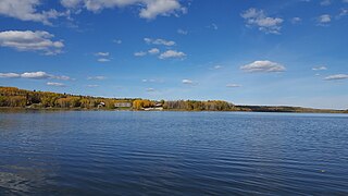
Ena Lake is the name of a lake and an adjacent unincorporated area and railway point in Unorganized Kenora District in northwestern Ontario, Canada, about 23 kilometres (14 mi) north of the city of Kenora. Formerly a stop on the Canadian National Railway, it is now a small cottage community of approximately 50 seasonal residents and 11 year round residents.

<span class="mw-page-title-main">Otter Lake (Saskatchewan)</span> Lake in Saskatchewan, Canada

Otter Lake is a lake in the province of Saskatchewan, Canada. It is located 50 miles (80 km) north of La Ronge and is accessible from Highway 102. The lake is part of the Churchill River system. The Churchill River runs through the lake. It is approximately 10 miles long and 9 miles at its widest point.

Agnew Lake is a lake on the Spanish River in the Sudbury District, Ontario, Canada. Its area is 2,940 hectares and its shoreline is 210 kilometres (130 mi) long.

<span class="mw-page-title-main">Four Mile Lake (Ontario)</span> Lake in southern Ontario, Canada

Four Mile Lake is a lake in the city of Kawartha Lakes in Central Ontario, Canada. The lake is 3.56 kilometres (2.21 mi) northeast of Coboconk, Ontario and 2.08 kilometres (1.29 mi) west of Burnt River. It is one of the Kawartha Lakes series of lakes and is in the Great Lakes Basin.

Long Lake is a lake formed by the widening of the Englehart River in Timiskaming District of northeastern Ontario, Canada. It consists of several segments and was previously known as Kushog, Kindogami and Robillard Lakes.

There are three Manistique Lakes in the Upper Peninsula of Michigan. The lakes include North Manistique Lake, Big Manistique Lake, and South Manistique Lake. The towns surrounding the lakes are Curtis, Germfask, and Helmer. The lakes are known for vacationing and fishing. They are also in close proximity to other natural sights such as the Great Lakes, rivers, and smaller lakes as well as tourist attractions including the Canada–US border, the Soo Locks, Mackinac Island, parks, and museums.

Wasekamio Lake is a glacial lake in northern Saskatchewan. It is part of a series of connected lakes that flow south into the Churchill River drainage system. These lakes from north to south are Wasekamio Lake, Turnor Lake, Frobisher Lake, and Churchill Lake. Just north of Wasekamio Lake is the Clearwater River that flows west to the Athabasca River.

<span class="mw-page-title-main">Lac la Plonge</span> Lake in Saskatchewan, Canada

Lac la Plonge is a glacial lake in Saskatchewan in the basin of the Beaver River near Lac Île-à-la-Crosse. It is located in the Boreal Forest near the Canadian Shield. Lac La Plonge on its north shore is accessed via Highway 165.

<span class="mw-page-title-main">Kesagami River</span> River in Ontario, Canada

The Kesagami River is a river in northern Cochrane District in Northeastern Ontario, Canada. It is part of the James Bay drainage basin, and is a left tributary of the Harricana River. The lower two-thirds of the river, from about Kesagami Lake and downstream for 112 kilometres (70 mi) to its mouth, are part of Kesagami Provincial Park.

<span class="mw-page-title-main">Larder River (Ontario)</span> River in Ontario, Canada

The Larder River is a river in Timiskaming District, in Northeastern Ontario, Canada. It is in the Saint Lawrence River drainage basin, and flows from its source at Larder Lake in geographic McFadden Township to its mouth as a left tributary of the Blanche River in the municipal township of Evanturel.

Sturgeon Bay Provincial Park is a provincial park on the western shore of Lake Winnipeg in Manitoba, Canada. The park is considered to be a Class Ib protected area under the IUCN protected area management categories. It is 144.9 km2 (55.9 sq mi) in size.

<span class="mw-page-title-main">Kesagami Provincial Park</span> Park in Ontario, Canada

Kesagami Provincial Park is in Cochrane District of Northern Ontario, Canada. It was established in 1983 and provides backcountry canoeing, camping, and fishing opportunities. The bulk of the park consists of a large near-rectangular piece of land surrounding Kesagami Lake, as well as a linear park that protects a 200 metres (660 ft) wide strip of land on both sides of the Kesagami River from Kesagami Lake to its mouth at the Harricana River. Its name means "warm water".

St. Raphael Provincial Park is a provincial park in northern Ontario, Canada, roughly halfway between Sioux Lookout and Pickle Lake, straddling the boundary of Kenora and Thunder Bay Districts. It was established on May 22, 2003, and provides backcountry canoeing and camping opportunities.

References

  1. 1 2 3 Georgetown University, Office of the Chief of Naval Operations (1956). Canadian North. United States: Technical Assistant to Chief of Naval Operations for Polar Projects (OP-O3A3). p. 254. Retrieved April 21, 2023.PD-icon.svg This article incorporates text from this source, which is in the public domain .
  2. 1 2 3 4 5 6 "Kesagami Provincial Park Management Statement". ontario.ca. Ontario Ministry of Natural Resources. April 1998. Archived from the original on March 2, 2023. Retrieved March 6, 2023.
  3. "Kesagami Lake". Geographical Names Data Base . Natural Resources Canada . Retrieved March 6, 2023.
  4. Schultz, Ken (March 31, 2006). "Solving the pike puzzle at Kesagami". ESPN.com. Archived from the original on March 7, 2023. Retrieved March 7, 2023.
  5. "Hudson's Bay Company. Mesackamee". pam.minisisinc.com. Archives of Manitoba. Retrieved March 6, 2023.{{cite web}}: CS1 maint: url-status (link)
  6. "Opimiskau Bay". Geographical Names Data Base . Natural Resources Canada . Retrieved March 6, 2023.
  7. "Newnham Bay". Geographical Names Data Base . Natural Resources Canada . Retrieved March 6, 2023.
  8. "Kochichi Bay". Geographical Names Data Base . Natural Resources Canada . Retrieved March 6, 2023.
  9. 1 2 3 Report of the Bureau of Mines Part I. Toronto: Ontario Bureau of Mines. 1904. p. 148. Retrieved March 8, 2023.PD-icon.svg This article incorporates text from this source, which is in the public domain .
  10. "Shore zone mapping and classification of a northern lake". Selected Water Resources Abstracts. The Center. 19 (5): 25. 1986. Retrieved March 7, 2023.