Related Research Articles

Victoria Island is a large island in the Arctic Archipelago that straddles the boundary between Nunavut and the Northwest Territories of Canada. It is the eighth-largest island in the world, and at 217,291 km2 (83,897 sq mi)1 in area, it is Canada's second-largest island. It is nearly double the size of Newfoundland (111,390 km2 [43,010 sq mi]), and is slightly larger than the island of Great Britain (209,331 km2 [80,823 sq mi]) but smaller than Honshu (225,800 km2 [87,200 sq mi]). The western third of the island lies in the Inuvik Region of the Northwest Territories; the remainder is part of Nunavut's Kitikmeot Region. The population of 2,168 is divided between two settlements, the larger of which is Cambridge Bay (Nunavut) and the other Ulukhaktok.

The Arctic Archipelago, also known as the Canadian Arctic Archipelago, is an archipelago lying to the north of the Canadian continental mainland, excluding Greenland and Iceland
The Victoria Cross Ranges are a set of mountain ranges in the Canadian Rockies, located to the northwest of Jasper. Of the 19 peaks contained within this range, five are named after Canadian recipients of the Victoria Cross. The area of the ranges is 678 square kilometres (262 sq mi).

Coutts is a village in southern Alberta, Canada that is a port of entry into the U.S. state of Montana. It is one of the busiest ports of entry on the Canada–United States border in western Canada. It connects Highway 4 to Interstate 15, an important trade route between Alberta, American states along I-15, and Mexico.

Aldersyde is a hamlet in Alberta, Canada within the Foothills County. Located between Highway 2 and Highway 2A south of Highway 7, the hamlet is approximately 8 kilometres (5.0 mi) southeast of Okotoks, 10 kilometres (6.2 mi) north of High River and 25 kilometres (16 mi) south of Calgary. The Canadian Pacific Kansas City Aldersyde subdivision runs through the hamlet.
Duchess is a village in southern Alberta, Canada that is surrounded by the County of Newell. It is north of Brooks and the Trans-Canada Highway.
There are several lakes named Mud Lake within the Canadian province of Alberta.
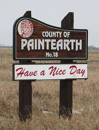
The County of Paintearth No. 18 is a municipal district in east central Alberta, Canada, located in Census Division No. 7. Its municipal office is located southeast of the Town of Castor near the intersection of Highway 12 and Highway 36.
De Winton is a hamlet in southern Alberta, Canada within the Foothills County. It is located just south of the City of Calgary and west of Highway 2A.
Byemoor is a hamlet in Alberta, Canada within the County of Stettler No. 6. It is located at the intersection of Highway 853 and Highway 589, approximately 70 kilometres (43 mi) southeast of Stettler and 80 kilometres (50 mi) northeast of Drumheller. It has an elevation of 845 metres (2,772 ft).

Etzikom is a hamlet in Alberta, Canada within the County of Forty Mile No. 8. It is approximately 20 kilometres (12 mi) east of Foremost on Highway 61.
Suffield is a hamlet in southern Alberta, Canada within Cypress County. It is located on the Trans-Canada Highway approximately 32 km (20 mi) northwest of Medicine Hat, and just south of CFB Suffield.

The Rocky Mountain Foothills are an upland area flanking the eastern side of the Rocky Mountains, extending from the Liard River in British Columbia southward into Alberta. Bordering the Interior Plains system, they are part of the Rocky Mountain System or Eastern System of the Western Cordillera of North America.
Aden is a locality in the County of Forty Mile No. 8, Alberta. It serves as a port of entry into the U.S. state of Montana for the nearby Canada – United States border crossing. The port of entry is located where Alberta Highway 880 continues as Secondary Highway 409 within Liberty County, Montana.
Cecil is a locality in Cypress County, Alberta, Canada.
Illingworth is a locality in Alberta, Canada.
Bantry is a locality in Alberta, Canada.
Howie is a locality in Alberta, Canada.

Alexis 133 is an Indian reserve of the Alexis Nakota Sioux Nation in Alberta, located within Lac Ste. Anne County. It is 70 kilometres northwest of Edmonton. In the 2016 Canadian Census, it recorded a population of 755 living in 173 of its 209 total private dwellings.
References
- ↑ "Agatha". Geographical Names Data Base . Natural Resources Canada.
- ↑ Place-names of Alberta. Ottawa: Geographic Board of Canada. 1928. p. 9.
50°07′59″N111°16′59″W / 50.133°N 111.283°W
| | This Southern Alberta location article is a stub. You can help Wikipedia by expanding it. |