Related Research Articles

The Stratford-upon-Avon and Midland Junction Railway (SMJR) was a railway company in the southern Midlands of England, formed at the beginning of 1909 by the merger of three earlier companies:

Kogi is a state in the North Central region of Nigeria, bordered to the west by the states of Ekiti and Kwara, to the north by the Federal Capital Territory, to the northeast by Nasarawa State, to the northwest by Niger State, to the southwest by Edo and Ondo states, to the southeast by the states of Anambra and Enugu, and to the east by Benue State. It is the only state in Nigeria to border ten other states. Named after the Hausa word for river (Kogi). Kogi State was formed from parts of Benue State, Niger State, and Kwara State on 27 August 1991. The state is nicknamed the "Confluence State" because the confluence of the River Niger and the River Benue occurs next to its capital, Lokoja.
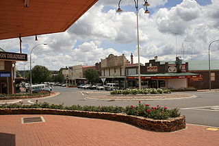
Crookwell is a small town located in the Southern Tablelands of New South Wales, Australia, in the Upper Lachlan Shire. At the 2016 census, Crookwell had a population of 2,641. The town is at a relatively high altitude of 887 metres and there are several snowfalls during the cooler months. The nearest major centre is the city of Goulburn which is about a half-hour drive to the south-east of the town. Crookwell is easily accessible to the state capital of Sydney and also the federal capital of Canberra.

Lokoja is a north-central city in Nigeria. It lies at the confluence of the Niger and Benue rivers and is the capital city of Kogi State. While the Bassa Nge, Yoruba (Oworo) and Nupe are indigenous to the area, other ethnic groups, including the Kupa-Nupe, Hausa, Ebira, Igala, Igbo, Bini/Edo, and Tiv have recently established themselves. Lokoja is projected to be the third fastest growing city on the African continent between 2020 and 2025, with a 5.93% growth rate. It was listed as a second class township by the 1917 township ordinance of the colonial administration, indicating that Lokoja is an old city.

Bauchi is a city in northeast Nigeria, the Administrative center of Bauchi State, of the Bauchi Local Government Area within that State, and of the traditional Bauchi Emirate. It is located on the northern edge of the Jos Plateau, at an elevation of 616 m. The Local Government Area covers an area of 3,687 km2 and had a population of 493,810 in 2006.
Itakpe is a town in Kogi State, Nigeria. The Itakpe Hills in and around the town of Itakpe contain very pure deposits of iron ore. The National Iron Ore Mining Company is located here. It supplies the steel works of Ajaokuta and Aladja, as well as producing ore for export.

The West Somerset Mineral Railway was a standard gauge line in Somerset, England. Originally expected to be 13 miles 420 yards (21.3 km) long its length as built was 11+1⁄2 miles (18.5 km), with a 310-yard (280 m) branch to Raleigh's Cross Mine. The line's core purpose was to carry iron ore northwards from mines on the Brendon Hills to Watchet harbour on the Bristol Channel. From there the ore was shipped northwards to Newport where it was unloaded onto railway wagons and hauled to ironworks at Ebbw Vale. The line opened as intended in 1861. Passenger services commenced in 1865. The mines' and line's "period of prosperity" ended in 1875 and by 1883 all mining had ceased. The line lingered on for passengers and small goods until 1898, when it closed.
Mary River is located on Baffin Island in the Qikiqtaaluk Region of Nunavut, about 936 km (582 mi) northwest of the capital, Iqaluit, and about 176 km (109 mi) southwest of Pond Inlet Inuktitut: Mittimatalik, lit. 'the place where the landing place is' The Inuit, name for the Mary River mountain is Nuluyait, meaning buttocks. There is a 4,000 year history in the area. For hundreds of years the semi-nomadic Inuit from the region that includes the hamlets of Pond Inlet and Igloolik, met at Mary River during the summer hunting caribou. By 2011, the population of the region was about 5,400 people, many of whom continued the traditional hunting and fishing lifestyle living off the land.

Railway stations in Nigeria include:
The Mary River Mine is an open-pit iron ore mine in the Mary River area of Baffin Island, Canada. It is operated by the Baffinland Iron Mines Corporation (BIMC). As of 2021, the operation consists of an open-pit mine, two work camps for hundreds of workers, a tote road—from the Mary River site to Milne Inlet—and port infrastructure at Milne Inlet. According to a 4-year study published in 2008, the Mary River Mine, with its four massive iron ore deposits of 65-70% pure iron ore was "one of the most promising undeveloped iron deposits on the planet". It was not until technological advances were in place in 2010, and the market for iron ore had dramatically increased that sizable financial backing for the high cost of development in a remote region known for its inhospitable climate, was available. The mine began operations in 2014, and the first shipment to Europe arrived in 2015. Baffinland is currently planning on expanding the mine. In February 2021, a group of Inuit hunters blockaded access to the mine for a week to protest the expansion.
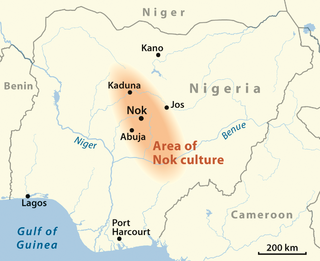
Taruga is an archeological site in Nigeria famous for the artifacts of the Nok culture that have been discovered there, some dating to 600 BC, and for evidence of very early iron working. The site is 60 km southeast of Abuja, in the Middle Belt.
Unryul County (은률군) is a county in South Hwanghae province, North Korea. The county is called by the name Eunyul (은율) in South Korea, due to the pronunciation differences between Northern and Southern Korean dialects.
The proposed Dalli Rajhara–Jagdalpur rail line, on paper for almost three decades, once completed, would connect Dalli Rajhara to Jagdalpur, both towns being in Chhattisgarh state in India. It would also connect Raipur, the capital city of Chhattisgarh, to Jagdalpur by rail via Durg. Jagdalpur, which is about 300 km from Raipur, is currently meaningfully connected to it only by road. There is though a roundabout rail route to reach Raipur from Jagdalpur via Koraput and Rayagada in Orissa; it is much longer and takes much longer time to be of any utility. In view of this, almost all the transport, in relation to both people and goods, between Raipur and Jagdalpur, happens only by road.
NMDC Steel Limited was formed under Government of India under Ministry of Steel with the help of NMDC's resources for setting up a 3 MTPA capacity greenfield Integrated Steel Plant based on Hi-Smelt technology in Nagarnar, located 16 km from Jagdalpur in Chhattisgarh state with an estimated outlay of Rs. 25500 crore. A pure-play miner, NMDC had in 2009-10 conceived the Nagarnar steel plant with the intention of moving up the value chain and diversifying its portfolio. The idea was also to hedge itself against the vagaries of iron ore prices. This is the only new large-scale steel plant currently fully ready to start production India, with little likelihood of a new plant of similar size plant coming up in the next few years. Tata Steel and JSW Steel are expanding capacity at their existing mills.

The Tatanagar–Bilaspur section is part of the Howrah–Nagpur–Mumbai line and connects Tatanagar in the Indian state of Jharkhand and Bilaspur in Chhattisgarh. Part of one of the major trunk lines in the country, it passes through an industrial-mining area and handles high volumes of freight, particularly coal and iron ore.

Iron Road Ltd is an Australian iron ore exploration and mining company, listed on the Australian Securities Exchange in Perth, Western Australia since 2008 with an objective to develop a world class magnetite mine and infrastructure in South Australia. Its two projects were the Central Eyre Iron Project (CEIP), the planned output of which was to be 24 million tonnes per annum of approximately 67 per cent iron concentrate for almost 30 years; and the Gawler Iron Project, in abeyance as of 2021. The company's corporate office is in Adelaide.
The Ọwọrọ ethnic nationality represents a group of people around the Niger-Benue confluence speaking a Yoruba dialect called Oworo. They are generally classified as part of Northeast Yoruba (NEY) of the Yoruba people.
The Okun people are the Yoruba speaking people found majorly in Kogi, but with settlements in Kwara, Ekiti, and Ondo states of Nigeria. Their dialects are generally classified in the Northeast Yoruba language (NEY) grouping. They are collectively called "Okun", which in Okun dialects could mean "Sorry", "Well-done", or as an all-encompassing greeting. Similarly, this form of greeting is also found among the Ekiti, Ijesha and Igbomina groups of Yoruba people.
The South East is the one of the six geopolitical zones of Nigeria representing both a geographic and political region of the country's inland southeast. It comprises five states – Abia, Anambra, Ebonyi, Enugu, and Imo.
The Duluth, Missabe and Northern Railway (DM&N) was a railroad company in the U.S. state of Minnesota. It was one of the earliest iron ore hauling railroads of the area, said to have built the largest iron ore docks in the world, and later was one of the constituent railroads in the merger that formed the Duluth, Missabe and Iron Range Railway.
References
- ↑ Apata Z.O (1995) "ADMINISTRATIVE INTEGRATION AND CONFLICT IN NIGERIA, 1840-1940: THE CASE OF NORTH-EAST YORUBALAND", Transafrican Journal of History Vol. 24, pp. 106-122. Published by: Gideon Were Publications.
- ↑ "Ore from Agbara in Nigeria". Railways Africa. November 2011. Retrieved 10 April 2023. (subscription required)
7°59′14″N6°38′33″E / 7.9871°N 6.6425°E
| | This Kogi State, Nigeria location article is a stub. You can help Wikipedia by expanding it. |