Agbe

Last updated
Agbe
ኣግበ
Sele
View from Debre Sema'it to Agbe lowlands.jpg
View from Debre Sema'it to Agbe lowlands
Ethiopia adm location map.svg
Red pog.svg
Agbe
Location within Ethiopia
Coordinates: 13°33′N39°3′E / 13.550°N 39.050°E / 13.550; 39.050
Country Ethiopia
Region Tigray
Zone Central
Woreda Tanqua Millash
Elevation
1,650 m (5,410 ft)
Time zone UTC+3 (EAT)

Agbe is the main locality of the Tanqua Millash district of the Tigray Region of Ethiopia. The municipality (tabia) centre is in Sele town. Until January 2020, Agbe belonged to the Abergele district.

Contents

Geography

The tabia occupies the southwestern footslopes of the Degua Tembien massif.

Geology

Rock sample of Adigrat Sandstone, collected at Kalazban Rock sample Adigrat sst Kalazban.jpg
Rock sample of Adigrat Sandstone, collected at Kalazban

From the higher to the lower locations, the following geological formations are present: [1]

Springs

As there are no permanent rivers, the presence of springs is of utmost importance for the local people. The main springs in the tabia are may Hitsare and Ayni Sele they are in Agbe, where construction works for a soft drinks factory have been started. [2]

Settlements

The tabia centre Sele holds a few administrative offices, a health post, a primary school, and some small shops. [2] There are a few more primary schools across the tabia. The main other populated places are: [3]

Economy and livelihood

The population lives essentially from crop farming, supplemented with off-season work in nearby towns. The farmers have adapted their cropping systems to the spatio-temporal variability in rainfall. In a certain way, there is irrigation of various fruits and peppers in “Shekah” irrigation with water from both sources Hitsare and Ayni Sele springs [4]

Historically Friday was the Market day of Agbe but Since 2004, it has been changed to Saturday by order of the local administration this day Saturday is the market day. [2]

History and culture

History

The history of the tabia is strongly confounded with the history of Tembien.

Religion and churches

Agbe is the birthplace of Ligaba Guangul Riese, who was the palace protocol of Emperor Yohannes IV. Children: Degezmati Gebremedhn Guangul and Degezmati Seyoum Guangul Grand Children: Fitawurari Girmay and Fitawurari Yohannes

Agbe is surrounded by many ancient monasteries including Qeqema Maryam, Chikh Selassie, and Mennewe Libanos

Most inhabitants are Orthodox Christians.

Roads and communication

The main road MekelleHagere SelamAbiy Addi runs through the centre of the tabia. There are regular bus services to these towns.

Tourism

Its mountainous nature and proximity to Mekelle makes the tabia fit for tourism. [5]

Trekking routes

Along Trek 8 in Kalazban near Agbe Kalazban near Agbe.jpg
Along Trek 8 in Kalazban near Agbe

Trekking routes have been established in this tabia. [6] The tracks are not marked on the ground but can be followed using downloaded .GPX files. [7]

Both treks involve a vertical interval of more than one kilometer and require good physical conditions.

Accommodation and facilities

Though facilities are basic, the inhabitants are hospitable. [8]

Related Research Articles

<span class="mw-page-title-main">Mika'el Abiy</span> Place in Tigray, Ethiopia

Mika’el Abiy is a tabia or municipality in the Dogu’a Tembien district of the Tigray Region of Ethiopia. The tabia centre is in Megesta village, located approximately 7 km to the southeast of the woreda town Hagere Selam.

<span class="mw-page-title-main">Degol Woyane</span> Municipality in Ethiopia

Degol Woyane is a tabia or municipality in the Dogu'a Tembien district of the Tigray Region of Ethiopia. It includes Dabba Selama, the oldest monastery of Ethiopia, and the most inaccessible in the world. The tabia centre is in Zala village, located approximately 10 km to the west of the woreda town Hagere Selam.

<span class="mw-page-title-main">Amanit</span> Municipality in Tigray Region, Ethiopia

Amanit is a tabia or municipality in the Dogu'a Tembien district of the Tigray Region of Ethiopia. The tabia centre is Addi Qeshofo village, located approximately 15 km to the southeast of the woreda town Hagere Selam.

<span class="mw-page-title-main">Debre Nazret</span> Municipality in Tigray Region, Ethiopia

Debre Nazret is a tabia or municipality in the Inderta district of the Tigray Region of Ethiopia. It belonged to Dogu'a Tembien up to January 2020. The tabia centre is in Togogwa town, located approximately 19 km to the east-southeast of Hagere Selam and 25 km to the west of Mekelle.

<span class="mw-page-title-main">Addi Azmera</span> Municipality in Ethiopia

Addi Azmera is a tabia or municipality in the Dogu'a Tembien district of the Tigray Region of Ethiopia. The name refers to good spring rains (“azmera”), in relation to the local microclimate. The tabia centre is in Tukhul town, located approximately half-way between the woreda town Hagere Selam and the regional capital Mekelle.

<span class="mw-page-title-main">Emni Ankelalu</span> Municipality in Ethiopia

Emni Ankelalu is a tabia or municipality in the Dogu'a Tembien district of the Tigray Region of Ethiopia. The tabia centre is in Mitslal Afras village, located approximately 20 km to the east of the woreda town Hagere Selam.

<span class="mw-page-title-main">Addilal</span> Municipality in Ethiopia

Addilal is a tabia or municipality in the Dogu'a Tembien district of the Tigray Region of Ethiopia. The tabia centre is in Addilal village, located approximately 19 km (12 mi) to the east of the woreda town Hagere Selam.

<span class="mw-page-title-main">Arebay</span> Municipality in Ethiopia

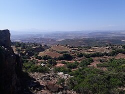
Arebay is a tabia or municipality in the Dogu'a Tembien district of the Tigray Region of Ethiopia organised around the Arebay mountain peaks. The tabia centre is in Arebay village, located approximately 13 km to the east-northeast of the woreda town Hagere Selam.

<span class="mw-page-title-main">Addi Walka</span> Municipality in Ethiopia

Addi Walka is a tabia or municipality in the Dogu'a Tembien district of the Tigray Region of Ethiopia. The tabia centre is in Kelkele village, located approximately 16 km northeast of the woreda town Hagere Selam.

<span class="mw-page-title-main">Mahbere Sillasie</span> Municipality in Ethiopia

Mahbere Sillasie is a tabia or municipality in the Dogu'a Tembien district of the Tigray Region of Ethiopia. The tabia centre is in Guderbo village, located approximately 2.5 km to the west-northwest of the woreda town Hagere Selam.

<span class="mw-page-title-main">Aregen</span> Municipality in Tigray Region, Ethiopia

Aregen is a tabia or municipality in the Dogu'a Tembien district of the Tigray Region of Ethiopia. The tabia centre is in Addi Gotet village, located approximately 11 km (6.8 mi) to the west-southwest of the woreda town Hagere Selam.

<span class="mw-page-title-main">Menachek</span> Municipality in Ethiopia

Menachek is a tabia or municipality in the Tanqua Millash district of the Tigray Region of Ethiopia. The tabia centre is in Addi Bayro village. Until January 2020 it belonged to the Dogu'a Tembien district.

<span class="mw-page-title-main">Mizan (Dogu'a Tembien)</span> Municipality in Tigray Region, Ethiopia

Mizan is a tabia or municipality in the Tanqua Millash district of the Tigray Region of Ethiopia. This tabia includes the rock church of Debre Sema'it, as well as Arefa, reputedly birthplace of the Queen of Sheba. The tabia centre is in Kerene village. Until 2020, Mizan belonged to the Dogu'a Tembien district.

<span class="mw-page-title-main">Inda Sillasie</span> Municipality in Tigray Region, Ethiopia

Inda Sillasie is a tabia or municipality in the Dogu'a Tembien district of the Tigray Region of Ethiopia. The tabia centre is in Migichi village, located approximately 13 km to the south-southeast of the woreda town Hagere Selam.

<span class="mw-page-title-main">Simret</span> Municipality in Tigray Region, Ethiopia

Simret is a tabia or municipality in the Tanqua Millash woreda of the Tigray Region, Ethiopia, which comprises the longest cave of Tigray in Zeyi, as well as Ras Alula’s birthplace in Mennewe. The tabia centre is in Dengolo village. Until January 2020, Simret belonged to the Dogu'a Tembien district.

<span class="mw-page-title-main">Mizane Birhan</span> Municipality in Ethiopia

Mizane Birhan is a tabia or municipality in the Dogu'a Tembien district of the Tigray Region of Ethiopia. The tabia centre is in Ma’idi village, located approximately 13 km to the southeast of the woreda town Hagere Selam.

<span class="mw-page-title-main">Selam (Dogu'a Tembien)</span> Municipality in Ethiopia

Selam is a tabia or municipality in the Dogu'a Tembien district of the Tigray Region of Ethiopia. The tabia centre is in Addi Werho village, located approximately 3 km to the northeast of the woreda town Hagere Selam.

Seret is a tabia or municipality in the Dogu'a Tembien district of the Tigray Region of Ethiopia. The tabia centre is in Inda Maryam Qorar village, located approximately 11 km to the southwest of the woreda town Hagere Selam.

<span class="mw-page-title-main">Lim'at</span> Municipality in Ethiopia

Lim’at is a tabia in the Dogu'a Tembien district of the Tigray Region of Ethiopia. The tabia centre is in Maygwa village, located approximately 8 km to the southwest of the woreda town Hagere Selam.

<span class="mw-page-title-main">Ayninbirkekin</span> Municipality in Ethiopia

Ayninbirkekin is a tabia or municipality in the Dogu'a Tembien district of the Tigray Region of Ethiopia. Literal meaning of Ayninbirkekin in Tigrinya is "We will not bend". The tabia centre is in Halah village, located approximately 8 km to the east of the woreda town Hagere Selam. Main town is Ala'isa, situated on the ridge overseeing the Giba valley.

References

  1. Sembroni, A.; Molin, P.; Dramis, F. (2019). Regional geology of the Dogu'a Tembien massif. In: Geo-trekking in Ethiopia's Tropical Mountains - The Dogu'a Tembien District. SpringerNature. ISBN   978-3-030-04954-6.
  2. 1 2 3 What do we hear from the farmers in Dogu'a Tenbien? [in Tigrinya]. Hagere Selam, Ethiopia. 2016. p. 100.{{cite book}}: CS1 maint: location missing publisher (link)
  3. Jacob, M. and colleagues (2019). Geo-trekking map of Dogu'a Tembien (1:50,000). In: Geo-trekking in Ethiopia's Tropical Mountains - The Dogu'a Tembien District. SpringerNature. ISBN   978-3-030-04954-6.
  4. Frankl, A. and colleagues (2013). "The effect of rainfall on spatio‐temporal variability in cropping systems and duration of crop cover in the Northern Ethiopian Highlands". Soil Use and Management. 29 (3): 374–383. doi:10.1111/sum.12041. hdl: 1854/LU-3123393 . S2CID   95207289.
  5. Geo-trekking in Ethiopia's Tropical Mountains - The Dogu'a Tembien District. SpringerNature. 2019. ISBN   978-3-030-04954-6.
  6. Description of trekking routes in Dogu'a Tembien. In: Geo-trekking in Ethiopia's Tropical Mountains - The Dogu'a Tembien District. SpringerNature. 2019. ISBN   978-3-030-04954-6.
  7. "Public GPS Traces tagged with nyssen-jacob-frankl".
  8. Nyssen, Jan (2019). "Logistics for the Trekker in a Rural Mountain District of Northern Ethiopia". Geo-trekking in Ethiopia's Tropical Mountains. GeoGuide. Springer-Nature. pp. 537–556. doi:10.1007/978-3-030-04955-3_37. ISBN   978-3-030-04954-6. S2CID   199198251.