Related Research Articles

A volcano is a rupture in the crust of a planetary-mass object, such as Earth, that allows hot lava, volcanic ash, and gases to escape from a magma chamber below the surface. The process that forms volcanoes is called volcanism.

Volcanic cones are among the simplest volcanic landforms. They are built by ejecta from a volcanic vent, piling up around the vent in the shape of a cone with a central crater. Volcanic cones are of different types, depending upon the nature and size of the fragments ejected during the eruption. Types of volcanic cones include stratocones, spatter cones, tuff cones, and cinder cones.

Mount Bachelor, formerly named Bachelor Butte, is a dormant stratovolcano atop a shield volcano in the Cascade Volcanic Arc and the Cascade Range of central Oregon. Named Mount Bachelor because it stands apart from the nearby Three Sisters, it lies in the eastern segment of the central portion of the High Cascades, the eastern segment of the Cascade Range. The volcano lies at the northern end of the 15-mile (24 km) long Mount Bachelor Volcanic Chain, which underwent four major eruptive episodes during the Pleistocene and the Holocene. The United States Geological Survey considers Mount Bachelor a moderate threat, but Bachelor poses little threat of becoming an active volcano in the near future. It remains unclear whether the volcano is extinct or just inactive.

Lassen Peak, commonly referred to as Mount Lassen, is a 10,457 ft (3,187 m) lava dome volcano in Lassen Volcanic National Park in Northern California. Located in the Shasta Cascade region above the northern Sacramento Valley, it is the southernmost active volcano in the Cascade Range of the Western United States, and part of the Cascade Volcanic Arc stretching from southwestern British Columbia to northern California. It supports many flora and fauna among its diverse habitats, which reach high elevations and are subject to frequent snowfall.

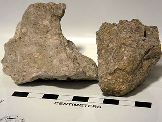
Pyroclastic rocks are clastic rocks composed of rock fragments produced and ejected by explosive volcanic eruptions. The individual rock fragments are known as pyroclasts. Pyroclastic rocks are a type of volcaniclastic deposit, which are deposits made predominantly of volcanic particles. 'Phreatic' pyroclastic deposits are a variety of pyroclastic rock that forms from volcanic steam explosions and they are entirely made of accidental clasts. 'Phreatomagmatic' pyroclastic deposits are formed from explosive interaction of magma with groundwater. The word pyroclastic is derived from the Greek πῦρ, meaning fire; and κλαστός, meaning broken.

Mount Katmai is a large active stratovolcano on the Alaska Peninsula in southern Alaska, located within Katmai National Park and Preserve. It is about 6.3 miles (10 km) in diameter with a central lake-filled caldera about two by three miles in size, formed during the Novarupta eruption of 1912. The caldera rim reaches a maximum elevation of 6,716 feet (2,047 m). In 1975 the surface of the crater lake was at an elevation of about 4,220 feet (1,286 m), and the estimated elevation of the caldera floor is about 3,400 ft (1,040 m). The mountain is located in Kodiak Island Borough, very close to its border with Lake and Peninsula Borough. The volcano has caused ten known fatalities due to gas exposure.
Ignimbrite is a type of volcanic rock, consisting of hardened tuff. Ignimbrites form from the deposits of pyroclastic flows, which are a hot suspension of particles and gases flowing rapidly from a volcano, driven by being denser than the surrounding atmosphere. New Zealand geologist Patrick Marshall (1869–1950) coined the term ignimbrite from the Latin igni- [fire] and imbri- [rain].

Cerro Azul, sometimes referred to as Quizapu, is an active stratovolcano in the Maule Region of central Chile, immediately south of Descabezado Grande. Part of the South Volcanic Zone of the Andes, its summit is 3,788 meters (12,428 ft) above sea level, and is capped by a summit crater that is 500 meters (1,600 ft) wide and opens to the north. Beneath the summit, the volcano features numerous scoria cones and flank vents.

The Allogromiida is an order of single-chambered, mostly organic-walled foraminiferans, including some that produce agglutinated tests (Lagynacea). Genetic studies indicate that some foraminiferans with agglutinated tests, previously included in the Textulariida or as their own order Astrorhizida, may also belong here. Allogromiids produce relatively simple tests, usually with a single chamber, similar to those of other protists such as Gromia. They are found as both marine and freshwater forms, and are the oldest forms known from the fossil record.

The Textulariida are an order of foraminifera that produce agglutinated shells or tests. An agglutinated test is one made of foreign particles glued together with an organic or calcareous cement to form an external shell on the outside of the organism. Commonly, the order had been made up of all species of Foraminifera with these types of shells, but genetic studies indicate these organisms do not form an evolutionary group, and several superfamilies in the order have been moved to the order Allogromiida. The remaining forms are sometimes divided into three orders: the Trochamminida and Lituolida, which have organic cement, and the Textulariida sensu stricto, which use a calcareous cement. All three orders or superfamilies are known as fossils from the Cambrian onwards.
The Flourmill Volcanoes, also known as The Flourmills, are a small volcano range near the west boundary of Wells Gray Provincial Park in east-central British Columbia, Canada. Located north of Mahood Lake and west of the Clearwater River, they form part of the Wells Gray-Clearwater volcanic field.

Black Crater is a shield volcano in the Western Cascades in Deschutes County, Oregon. Located near McKenzie Pass, the volcano has a broad conical shape with gentle slopes. The volcano likely formed during the Pleistocene and has not been active within the last 50,000 years. Eruptive activity at the volcano produced mafic lava flows made of basaltic andesite and olivine basalt; it also formed a number of cinder cones. A normal fault occurs on the western side of the volcano, trending north–south. The volcano has been eroded by glaciers, which carved a large cirque into the northeastern flank of the mountain, forming its current crater.

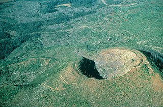
Blue Lake Crater is a maar, or a broad, low-relief volcanic crater, in the U.S. state of Oregon. Located in Jefferson County, it consists of three overlapping craters, which hold Blue Lake. The drainage basin for Blue Lake has very steep, forested slopes and is mostly part of the explosion crater left by the volcano's eruption. The volcano lies within the Metolius River basin, which supports a wide array of plant life, large and small mammals, and more than 80 bird species. A 2009 Oregon law designated the Metolius River basin as an area of critical concern, preventing large-scale development and protecting wildlife.

The Big Raven Plateau is an intermontane plateau in Cassiar Land District of northwestern British Columbia, Canada. It lies on the Tahltan Highland and is surrounded by several valleys, including those of Mess Creek, Kakiddi Creek, Chakima Creek, Walkout Creek and the Klastline River. The plateau is drained by many small streams that flow into these neighbouring valleys and, unlike the valleys, it is relatively barren of vegetation. Stream erosion has resulted in the creation of canyons with intervening ridges on the eastern and western sides of the plateau, resulting in the creation of rugged terrain. The plateau is in Mount Edziza Provincial Park which is one of the largest provincial parks in British Columbia. Access to the Big Raven Plateau is mainly by aircraft or by a network of footpaths from surrounding roads.

Tennena Cone, alternatively Icebridge Cone, is a small volcanic cone in Cassiar Land District of northwestern British Columbia, Canada. It has an elevation of 2,390 metres and lies on the western flank of Ice Peak, the prominent south peak of Mount Edziza. The cone is almost completely surrounded by glacial ice of Mount Edziza's ice cap which covers an area of around 70 square kilometres. Tennena Cone is 200 metres high, 1,200 metres long and up to 600 metres wide, its symmetrical structure resembling a black pyramid. The cone and the surrounding area are in Mount Edziza Provincial Park which also includes the Spectrum Range to the south.

Volborthella is an animal of uncertain classification, whose fossils pre-date 530 million years ago. It has been considered for a period a cephalopod. However discoveries of more detailed fossils showed that Volborthella’s small, conical shell was not secreted but built from grains of the mineral silicon dioxide (silica), and that it was not divided into a series of compartments by septa as those of fossil shelled cephalopods and the living Nautilus are. This illusion was a result of the laminated texture of the organisms' tests. Therefore, Volborthella’s classification is now uncertain. It has been speculated that it may in fact represent a sclerite of a larger organism, on the basis of one specimen; however, it may be premature to accept this hypothesis, as the arrangement of sclerites producing this impression may have occurred by chance. The Ordovician scleritome-bearing Curviconophorus, as well as the Halwaxiids, lobopods and echinoderms, demonstrate the diversity of organisms which may produce a scleritome of this nature. The related Campitius was originally suggested to be part of a radula rather than a scleritome, but is now considered a synonym of Volborthella.
Calabozos is a Holocene caldera in central Chile's Maule Region. Part of the Chilean Andes' volcanic segment, it is considered a member of the Southern Volcanic Zone (SVZ), one of the three distinct volcanic belts of South America. This most active section of the Andes runs along central Chile's western edge, and includes more than 70 of Chile's stratovolcanoes and volcanic fields. Calabozos lies in an extremely remote area of poorly glaciated mountains.

Mount Cayley is an eroded but potentially active stratovolcano in the Pacific Ranges of southwestern British Columbia, Canada. Located 45 km (28 mi) north of Squamish and 24 km (15 mi) west of Whistler, the volcano resides on the edge of the Powder Mountain Icefield. It consists of massif that towers over the Cheakamus and Squamish river valleys. All major summits have elevations greater than 2,000 m (6,600 ft), Mount Cayley being the highest at 2,385 m (7,825 ft). The surrounding area has been inhabited by indigenous peoples for more than 7,000 years while geothermal exploration has taken place there for the last four decades.
Foraminiferal tests are the tests of Foraminifera.
Idiji Ridge is a mountain ridge extending east of Tencho Glacier on the southern flank of Mount Edziza in northwestern British Columbia, Canada. It is bounded on the south by a valley containing an unnamed creek, on the east by Tennaya Creek valley and on the north by cirques extending east of Ice Peak. Idiji Ridge takes its name from the adjacent Idiji Glacier; Idiji means "it thunders" in the Tahltan language.
References
- 1 2 "Agglutinate". United States Geological Survey. 2016. Retrieved 2024-09-19.
- ↑ Duebendorfer, Ernest M.; Smith, Eugene Irwin, eds. (2008). Field Guide to Plutons, Volcanoes, Faults, Reefs, Dinosaurs, and Possible Glaciation in Selected Areas of Arizona, California, and Nevada. Geological Society of America. p. 185. ISBN 978-0-8137-0011-3.
| | This volcanology article is a stub. You can help Wikipedia by expanding it. |