
Agios Prokopios (Greek : Άγιος Προκόπιος) is a seaside village on the island of Naxos, Greece. It is known for its beaches on the Aegean and is a favorite tourist attraction. [1] [2] [3]
At the 2021 census it numbered 182 residents. [4]
Agios Prokopios (Greek : Άγιος Προκόπιος) is a seaside village on the island of Naxos, Greece. It is known for its beaches on the Aegean and is a favorite tourist attraction. [1] [2] [3]
At the 2021 census it numbered 182 residents. [4]
Agios Prokopios is hot spot for tourists, appart from the long sandy beaches, the village itself has a small churh. Not far from it is a resort place by the name of Stelida. the "Red Lake" is another attraction near the village, flocks of Herons are known to use the spot as a resting place before continuing their flight to Africa. [3]
On the beginning of July, every 8th of the month there is an annual relgious feast in honour of Agios Prokopios [3]
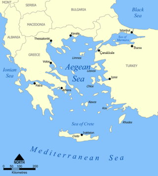
The Aegean Sea is an elongated embayment of the Mediterranean Sea between Europe and Asia. It is located between the Balkans and Anatolia, and covers an area of some 215,000 km2 (83,000 sq mi). In the north, the Aegean is connected to the Marmara Sea, which in turn connects to the Black Sea, by the straits of the Dardanelles and the Bosphorus, respectively. The Aegean Islands are located within the sea and some bound it on its southern periphery, including Crete and Rhodes. The sea reaches a maximum depth of 3,544 m (11,627 ft) to the east of Crete. The Thracian Sea and the Sea of Crete are main subdivisions of the Aegean Sea.

The Cyclades are an island group in the Aegean Sea, southeast of mainland Greece and a former administrative prefecture of Greece. They are one of the island groups which constitute the Aegean archipelago. The name refers to the archipelago forming a circle around the sacred island of Delos. The largest island of the Cyclades is Naxos, however the most populated is Syros.

Naxos is a Greek island and the largest of the Cyclades. It was the centre of the archaic Cycladic culture. The island is famous as a source of emery, a rock rich in corundum, which until modern times was one of the best abrasives available.

Paros is a Greek island in the central Aegean Sea. Part of the Cyclades island group, it lies to the west of Naxos, from which it is separated by a channel about 8 kilometres wide. It lies approximately 150 km south-east of Piraeus. The Municipality of Paros includes numerous uninhabited offshore islets totaling 196.308 square kilometres (75.795 sq mi) of land. Its nearest neighbor is the municipality of Antiparos, which lies to its southwest. In ancient Greece, the city-state of Paros was located on the island.
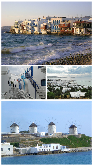
Mykonos is a Greek island, part of the Cyclades, lying between Tinos, Syros, Paros and Naxos. The island has an area of 85.5 square kilometres (33.0 sq mi) and rises to an elevation of 341 metres at its highest point. At the 2021 census, there were 10,704 inhabitants, most of whom lived in the largest town, Mykonos, which is on the west coast. The town is also known as Chora.

Skiathos is a small Greek island in the northwest Aegean Sea. Skiathos is the westernmost island in the Northern Sporades archipelago, east of the Pelion peninsula in Magnesia on the mainland, and west of the island of Skopelos.

Agios Nikolaos or Aghios Nikolaos is a coastal city on the Greek island of Crete, lying east of the island's capital Heraklion, north of the city of Ierapetra and west of the city of Sitia.

Stoupa is a village on the coast of the southern Peloponnese peninsula in Greece. It is part of the municipal unit of Lefktro within the municipality of West Mani, in Messenia and the historic region of Mani Peninsula.

Donousa, and sometimes spelled Donoussa, is an island and a former community in the Cyclades, Greece. Since the 2011 local government reform it is part of the municipality Naxos and Lesser Cyclades, of which it is a municipal unit. Donousa is the easternmost island of the Lesser Cyclades.
Agios Efstratios or Saint Eustratius, colloquially Ai Stratis, anciently Halonnesus or Halonnesos, is a small Greek island in the northern Aegean Sea about 30 kilometres southwest of Lemnos and 80 kilometres northwest of Lesbos. The municipality has an area of 43.325 km2. Together with Lemnos and nearby islets it forms the regional unit of Lemnos, part of the Greek archipelagic region of the North Aegean.

Kythnos, commonly called Thermia, is a Greek island and municipality in the Western Cyclades between Kea and Serifos. It is 56 nautical miles (104 km) from the Athenian harbor of Piraeus. The municipality Kythnos is 100.187 km2 (38.68 sq mi) in area and has a coastline of about 100 km (62 mi). Mount Kakovolo is island's highest peak (365m).

Koufonisia are a small island complex and a former community in the Cyclades, Greece. Since the 2011 local government reform it is part of the municipality Naxos and Lesser Cyclades, of which it is a municipal unit. The municipal unit has an area of 26.025 km2.

Naxos Island National Airport is an airport in Naxos, Greece. It is located near Agios Prokopios, 3 km from Naxos City. The airport opened in 1992.
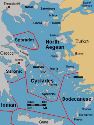
The North Aegean islands are a number of scattered islands in the North Aegean Sea, also known as the Northeastern Aegean islands, belonging mostly to Greece and a few of them to Turkey. The islands do not form a physical chain or group, but are frequently grouped together for tourist or administrative purposes. To the south are the Dodecanese islands; and to the west are the Cyclades and Sporades islands.

Talo'fo'fo, formerly Talofofo, is a village located in the southern part of the United States territory of Guam, on the east coast. The village center is located in the hills above the coast, while the smaller coastal community below the cliff is known as Ipan.

Apolakkia is a village in the municipal unit of South Rhodes, on the island of Rhodes, in the South Aegean region of Greece. In 2021 its population was 409.

Pyrgadikia is a Greek village in the Chalkidiki peninsula. It is located in the south-eastern part of Chalkidiki, built on the coast of Siggitikos Bay. It is part of the Aristotelis municipality and the Panagia municipal unit. The central church of the village is dedicated to Panagia and celebrated every year on the eighth of September.

Azolimnos Syros is a village on the southeast coast of the Greek island of Syros. Syros belongs to the Cyclades island group. Azolimnos is 6 km from the Syros capital, Ermoupoli. Azolimnos beach is a popular destination for summer holiday makers wishing to go swimming.

Filoti is a semi-mountainous village of central Naxos, Greece, with a population of 1,617 residents, located at the foot of Mt. Zas, at an altitude of 400 meters, about 18.2 kilometres (11.3 mi) from the city of Naxos. It is located on the slopes of two hills and consists of three settlements, Rachidi, Klefaros and Lioiri. Its stand out is the Orthodox church of Panagia Filotitissa that is dedicated to the Assumption of the Virgin, a basilica built in 1718 in the place of an old Byzantine church. The economy of the village is mainly based on livestock products, secondarily in agriculture and tourism. It has a Primary School, a Professional High School, a Multipurpose Regional Doctor, a Citizen Service Center (KEP), a Post office, a dentist and a pharmacy.
37°4′30″N25°21′6″E / 37.07500°N 25.35167°E
| | This South Aegean location article is a stub. You can help Wikipedia by expanding it. |