Related Research Articles
The Coral Sea Islands Territory is an external territory of Australia which comprises a group of small and mostly uninhabited tropical islands and reefs in the Coral Sea, north-east of Queensland, Australia. The only inhabited island is Willis Island. The territory covers 780,000 km2 (301,160 sq mi), most of which is ocean, extending east and south from the outer edge of the Great Barrier Reef and includes Heralds Beacon Island, Osprey Reef, the Willis Group and fifteen other reef/island groups. Cato Island is the highest point in the Territory.
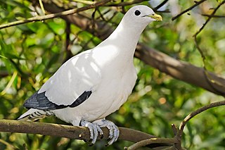
The Brook Islands National Park is a national park in Cassowary Coast Region, Queensland, Australia, 1246 km northwest of Brisbane, with an area of 0.9 km2. It was established in 1994 and comprises three islands which lie off the coast 7 km north-east of Cape Richards on Hinchinbrook Island and 30 km east of the nearest mainland town of Cardwell. The fourth island of the Brooks group, South Island, is not part of the national park but is protected by the Great Barrier Reef Marine Park Authority. Public access to the three islands in the national park is prohibited in order to protect breeding birds, especially the Torresian imperial-pigeon. The islands have no roads, walking tracks or other facilities. Popular activities in the waters around the islands are boating, snorkelling and fishing. The islands are managed by the Queensland Parks and Wildlife Service. The Park's IUCN category is II.
Hinchinbrook Island National Park is Australia's largest island national park. It is situated along the Cassowary Coast Queensland, Australia. The nearest capital city is Brisbane approximately 1,240 km to the south. Lucinda is 135 km or 1.5 hours drive north of Townsville being the closest North Queensland provincial city. Cairns a Far North Queensland provincial city is two and a half to 3 hours drive north from Cardwell. The main geographical features in the park are the rugged Hinchinbrook Island, including Mount Bowen, The Thumb, Mount Diamantina and Mount Straloch.

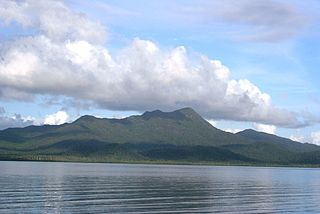
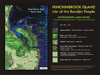
Hinchinbrook Island is an island in the Cassowary Coast Region, Queensland, Australia. It lies east of Cardwell and north of Lucinda, separated from the north-eastern coast of Queensland by the narrow Hinchinbrook Channel. Hinchinbrook Island is part of the Great Barrier Reef Marine Park and wholly protected within the Hinchinbrook Island National Park, except for a small and abandoned resort. It is the largest island on the Great Barrier Reef. It is also the largest island national park in Australia.
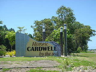
Cardwell is a coastal town and rural locality in the Cassowary Coast Region, Queensland, Australia. In the 2016 census, the locality of Cardwell had a population of 1,309 people.

Caloundra is a coastal town and the southernmost town in the Sunshine Coast Region in South East Queensland, Australia.

Bribie Island is the smallest and most northerly of three major sand islands forming the coastline sheltering the northern part of Moreton Bay, Queensland, Australia. The others are Moreton Island and North Stradbroke Island. Bribie Island is 34 kilometres long, and 8 kilometres at its widest. Archibald Meston believed that the name of the island came from a corruption of a mainland word for it, Boorabee meaning koala. However, the correct Joondaburri name for the island is in fact Yarun.

Agnes Water is a coastal town and a locality in the Gladstone Region, Queensland, Australia. In the 2021 census, Agnes Water had a population of 2,729 people.

Far North Queensland (FNQ) is the northernmost part of the Australian state of Queensland. Its largest city is Cairns and it is dominated geographically by Cape York Peninsula, which stretches north to the Torres Strait, and west to the Gulf Country. The waters of Torres Strait include the only international border in the area contiguous with the Australian mainland, between Australia and Papua New Guinea.

The D'Aguilar Highway is a two-lane highway linking the Bruce Highway near Caboolture with Kingaroy in the state of Queensland, Australia. Major towns along the route include Woodford, Kilcoy, Blackbutt, Yarraman, Nanango and Kingaroy. The highway is approximately 164 km (102 mi) in length. The D'Aguilar Highway's highest elevation along its length is 527 m just north of Yarraman, and the lowest point is at 26.8m just west of Caboolture.

The Herbert River is a river located in Far North Queensland, Australia. The southernmost of Queensland's wet tropics river systems, it was named in 1864 by George Elphinstone Dalrymple explorer, after Robert George Wyndham Herbert, the first Premier of Queensland.

Lucinda is a coastal town and locality in the Shire of Hinchinbrook, Queensland, Australia. In the 2016 census, the locality of Lucinda had a population of 406 people.

The Normanby River, comprising the East Normanby River, the West Normanby River, the East Normanby River North Branch, the East Normanby River South Branch and the Granite Normanby River, is a river system located in Far North Queensland, Australia.

The geography of Queensland in the north-east of Australia, is varied. It includes tropical islands, sandy beaches, flat river plains that flood after monsoon rains, tracts of rough, elevated terrain, dry deserts, rich agricultural belts and densely populated urban areas.

Weeroona Island is a 77 ha island in the Australian state of South Australia located in Germein Bay, Spencer Gulf between the city of Port Pirie and town of Port Germein. It features the wreck of the York, coastal shacks, sandy beaches and is connected with the mainland by a 300m long causeway spanning mangroves and tidal flats.

Rockingham Bay is a bay in Far North Queensland, Australia.

Kinbombi is a rural town and locality in the Gympie Region, Queensland, Australia. In the 2016 census, the locality of Kinbombi had a population of 37 people.

Bemerside is a rural locality in the Shire of Hinchinbrook, Queensland, Australia. In the 2016 census, Bemerside had a population of 241 people.
Hinchinbrook is a locality in the Cassowary Coast Region, Queensland, Australia. In the 2016 census, Hinchinbrook had a population of 0 people.

The Thorsborne Trail is a popular long-distance bushwalking trail in Queensland. It runs along the east coast of Hinchinbrook Island National Park and is 32 kilometres (20 mi) long. It has been described as "iconic" by Australian Geographic and one of the best multi-day hiking trails across Australia by The Guardian. The track is accessed by private ferry services to/from Ramsay Bay or George Point – the schedule varies based on tides.
References
- ↑ "Agnes Island – island in the Cassowary Coast Region (entry 159)". Queensland Place Names. Queensland Government . Retrieved 11 June 2020.
- ↑ "Map of Agnes Island in Queensland - Bonzle Digital Atlas of Australia". maps.bonzle.com.
- ↑ "Agnes Island - Beach in Lucinda Hinchinbrook QLD". SLS Beachsafe. Archived from the original on 21 April 2019. Retrieved 11 June 2020.
| | This Queensland location article is a stub. You can help Wikipedia by expanding it. |