Amaliada is a town and a former municipality in northwestern Elis, West Greece, Greece. Since the 2011 local government reform it is part of the municipality Ilida, of which it is the seat and a municipal unit. The municipal unit has an area of 251.945 km2. It is near the archaeological site of Elis, the city-state whose territory was the site of the ancient Olympic Games. It is situated in the plains of Elis, 6 km from the Ionian Sea. It is 10 km southeast of Gastouni, 16 km northwest of Pyrgos and 60 km southwest of Patras.

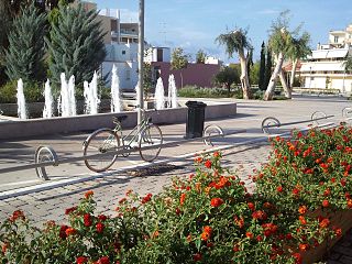
Pyrgos is a city in the northwestern Peloponnese, Greece, capital of the regional unit of Elis and the seat of the Municipality of Pyrgos. The city is located in the middle of a plain, 4 kilometres from the Ionian Sea. The river Alfeios flows into sea about 7 km (4 mi) south of Pyrgos. The population of the town Pyrgos is 26,052, and of the municipality 45,365 (2021). Pyrgos is 16 km (10 mi) west of Olympia, 16 km (10 mi) southeast of Amaliada, 70 km (43 mi) southwest of Patras and 85 km (53 mi) west of Tripoli.
Avgeio is a village in the northern part of the municipal unit of Amaliada, Elis, Greece. It is situated in a plain near the ancient city of Elis, 1 km southwest of Kalyvia, 2 km northeast of Sosti and 9 km north of Amaliada.
Agios Georgios is a community in the municipality of Pyrgos, Elis, Greece. It is situated at the foot of low hills, 3 km north of the centre of Pyrgos, 2 km northeast of Lasteika and 2 km southeast of Prasino, in the municipal unit Iardanos. Settlement in the village started between 1900 and 1920. It has a soccer (football) club named Nikiforos.

Pineia is a former municipality in Elis, West Greece, Greece. Since the 2011 local government reform it is part of the municipality Ilida, of which it is a municipal unit. The municipal unit has an area of 148.572 km2. Its seat of administration was in the village Simopoulo. Pineia is named after the river Pineios, which forms its northern border. The area is hilly and sparsely populated. It is about 20 km east of Amaliada, 25 km northeast of Pyrgos and 45 km southwest of Patras.

Lasiona is a former municipality in Elis, West Greece, Greece. Since the 2011 local government reform it is part of the municipality Archaia Olympia, of which it is a municipal unit. The municipal unit has an area of 119.528 km2. Its seat of administration was the village Antroni. Lasiona is situated in a mountainous area on the border with Achaea, 20 km north of Olympia, 27 km northeast of Pyrgos and 50 km south of Patras. The Greek National Road 33 passes through the municipal unit.
Varda is a town and a community in the municipal unit of Vouprasia, Elis, Greece. It was the seat of the former municipality Vouprasia. The community Varda consists of the town Varda and the villages Kougaiika, Komi, Sympanio and Psari. Varda is situated in the plains near the Ionian Sea, and east of the Kotychi lagoon. It is 2 km southeast of Manolada, 3 km southwest of Nea Manolada, 14 km northeast of Lechaina and 40 km southwest of Patras. The railway from Patras to Pyrgos passes west of the town, and the Greek National Road 9 passes east of the town.
Aetorrachi is a settlement and a community in the municipal unit of Vouprasia, Elis Greece. It is located in the hills of northern Elis, 3 km east of Borsi, 14 km southeast of Varda and 30 km north of Pyrgos. It is close to the northern shore of the Pineios reservoir, and south of the Movri hills. The community includes the village Dafni.
Pelopio is a settlement in the municipality of Ancient Olympia, Elis, Greece. Pelopio is 3 km east of Smila, 4 km northwest of Olympia and 5 km southwest of Chelidoni. The Greek National Road 74 passes south of the village.
Agia Kyriaki is a mountain village in the municipal unit of Lasiona, Olympia, Elis, Greece. It is situated in the southwestern foothills of Mount Erymanthos at 940 metres elevation, 4 km west of Lampeia, 7 km northeast of Antroni and 26 km northeast of Olympia.
Kryovrysi is a mountain village and a community in the municipal unit of Lasiona, Olympia, Elis, Greece. The community consists of the villages Kryovrysi and Kalyvia. It is situated in the southwestern foothills of Mount Erymanthos, at 960 m elevation. It is 4 km west of Agrampela, 5 km southeast of Kalentzi, 7 km north of Lampeia and 15 km northeast of Antroni. The source of the river Pineios is near Kryovrysi. Downstream from Kryovrysi, near the river bed of the Pineios, is the cave Drakotrypa.
Gryllos is a village and a community in the municipal unit of Skillounta, Elis, Greece. The community includes the small village Chani Gryllou. It is 3 km northwest of Graikas, 3 km northeast of Vrina and 5 km southeast of Krestena. The Greek National Road 76 runs through Chani Gryllou. Gryllos suffered damage from the 2007 Greek forest fires.
Alfeiousa is a village in Elis, Greece.
Myrtia or Myrtea is a village in the municipality of Pyrgos, Elis, Greece. It is located on a hillside near the Ionian Sea. It is 3 km southeast of Douneika, 3 km southwest of Alpochori, 3 km north of Skourochori and 9 km northwest of Pyrgos town centre. The Greek National Road 9/E55 passes northeast of the village.
Leventochori is a village in the municipality of Pyrgos, Elis, Greece. It is located near the Ionian Sea, at the foot of a low hill. It is 1 km south of Skafidia, 3 km west of Skourochori, 4 km northeast of Katakolo and 10 km west of Pyrgos town centre.
Korakochori is a village and a community in the municipality of Pyrgos, Elis, Greece. The community includes the small villages Agios Andreas, Kallithea and Bouka. It is located by the Ionian Sea, 2 km southwest of Leventochori, 3 km north of Katakolo and 11 km west of Pyrgos town centre.
Katsaros is a settlement in the municipal unit of Iardanos, Elis, Greece. It is situated at the foot of low hills, at 80 m elevation. It is 2 km southeast of Vounargo, 2 km southwest of Fonaitika and 6 km northwest of Pyrgos
Prasino is a village and a community in the municipal unit of Iardanos, Elis, Greece. It is 2 km northwest of Agios Georgios, 3 km southeast of Vounargo and 5 km northwest of Pyrgos town centre. The community consists of the villages Prasino, Glykorizo and Keramidia. Its elevation is 70 m.
Kyllini is a port town and a community in the municipal unit of Kastro-Kyllini, Elis, Greece. It is situated on the Ionian Sea coast, 11 km west of Andravida, 28 km northeast of Zakynthos and 39 km northwest of Pyrgos. From the port of Kyllini there are several ferry connections to the Ionian islands Zakynthos and Cephalonia. It was the terminus of the now dismantled Kavasila–Kyllini railway.
Agios Ioannis is a settlement and community in the municipality of Pyrgos, Elis, Peloponnese, Greece. It was an independent community between 1912 and 1997. The name translates as "Saint John".
