
Ainsworth Bay in the Tierra del Fuego region of Chile is a coastal inlet fed by the meltwater of Marinelli Glacier. [1] The Marinelli Glacier is in a state of retreat. [2]
Ainsworth Bay in the Tierra del Fuego region of Chile is a coastal inlet fed by the meltwater of Marinelli Glacier. [1] The Marinelli Glacier is in a state of retreat. [2]

Tierra del Fuego is an archipelago off the southernmost tip of the South American mainland, across the Strait of Magellan. The archipelago consists of the main island, Isla Grande de Tierra del Fuego, with an area of 48,100 km2 (18,572 sq mi), and a group of many islands, including Cape Horn and Diego Ramírez Islands. Tierra del Fuego is divided between Chile and Argentina, with the latter controlling the eastern half of the main island and the former the western half plus the islands south of Beagle Channel and the southernmost islands. The southernmost extent of the archipelago is just north of latitude 56°S.

The Magallanes Region, officially the Magallanes y la Antártica Chilena Region, is one of Chile's 16 first order administrative divisions. It is the southernmost, largest, and second least populated region of Chile. It comprises four provinces: Última Esperanza, Magallanes, Tierra del Fuego, and Antártica Chilena.

Tierra del Fuego, officially the Province of Tierra del Fuego, Antarctica and South Atlantic Islands, is the southernmost, smallest, and least populous Argentine province.

The Magellanic subpolar forests are a terrestrial ecoregion of southernmost South America, covering parts of southern Chile and Argentina, and are part of the Neotropical realm. It is a temperate broadleaf and mixed forests ecoregion, and contains the world's southernmost forests.

Isla Grande de Tierra del Fuego also formerly Isla de Xátiva is an island near the southern tip of South America from which it is separated by the Strait of Magellan. The western portion (61.4%) of the island is in Chile, while the eastern portion is in Argentina. It forms the major landmass in an extended group of islands or archipelago also known as Tierra del Fuego.

Beagle Channel is a strait in the Tierra del Fuego Archipelago, on the extreme southern tip of South America between Chile and Argentina. The channel separates the larger main island of Isla Grande de Tierra del Fuego from various smaller islands including the islands of Picton, Lennox and Nueva; Navarino; Hoste; Londonderry; and Stewart. The channel's eastern area forms part of the border between Chile and Argentina and the western area is entirely within Chile.
Eric Earle Shipton, CBE, was an English Himalayan mountaineer.

Nothofagus pumilio, the lenga beech, is a deciduous tree or shrub in the Nothofagaceae family that is native to the southern Andes range, in the temperate forests of Chile and Argentina to Tierra del Fuego, from 35° to 56° South latitude. This tree is in the same genus as the coihue. It regenerates easily after fires. The wood is of good quality, moderate durability, and is easy to work with. It is used in furniture, shingles and construction and sometimes as a substitute for American black cherry in the manufacturing of cabinets.

Mount Darwin is a peak in Isla Grande de Tierra del Fuego forming part of the Cordillera Darwin, the southernmost range of the Andes, just to the north of the Beagle Channel.
Tierra del Fuego Province is one of four provinces in the southern Chilean region of Magallanes and Antártica Chilena (XII). It includes the Chilean or western part of the main island of Tierra del Fuego, except for the part south of the Cordillera Darwin, which is in Antártica Chilena Province.

Alberto de Agostini National Park is a protected area that was created on January 22, 1965, on land that was formerly part of the "Hollanda" forest reserve and "Hernando de Magallanes National Park". It covers 1,460,000 hectares and includes the Cordillera Darwin mountain range, which is the final land-based stretch of the Andes before it becomes a chain of mountains appearing as small islands that sink into the Pacific Ocean and the Beagle Channel.
The Cordillera Darwin is an extensive mountain range mantled by an ice field that is located in Chile.
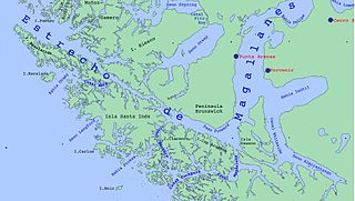
Almirantazgo Fjord, also known as Almirantazgo Sound or Admiralty Sound, is a Chilean fjord located in the far south of the country at 54°19′S69°30′W. The fjord cuts deeply into the west coast of the Isla Grande de Tierra del Fuego, extending southeastwards from the Whiteside Channel, which separates Isla Grande from Dawson Island. On its south side several smaller fjords and bays make significant indentations into the north coastline of the Cordillera Darwin. One of these, Ainsworth Bay, is home to a colony of elephant seals. Azopardo River empties into the head of the fjord.

Maytenus magellanica is a small evergreen tree from the genus Maytenus, up to 5 meters (16 ft), in the Celastraceae. It grows in southern Argentina and Chile from 36ºS to Cape Horn (56ºS).

The Señoret Channel is a navigable surface water body in the Patagonian region of Chile. One of the major towns along the channel is Puerto Natales. Hermann Eberhard, the first European to explore the interior of northern Patagonia, used the Señoret Channel to navigate northward in order to access the remote portions of this region. One of his findings was the Milodon Cave at the base of the Cerro Benitez, where he recovered remains of the extinct Giant sloth and evidence of habitation of early man from 10,000 BC.

Marinelli Glacier is a tidewater glacier located in Alberto de Agostini National Park, Isla Grande de Tierra del Fuego. The glacier spills out from the backbone of the Cordillera Darwin and calves into Ainsworth Bay, an embayment of the Almirantazgo Fjord. The Marinelli Glacier is in a state of retreat, beginning at least as early as 1960 and continuing to the present time. Meltwater of Marinelli glacier discharges to form the headwaters of Marinelli Creek.
Marinelli Creek is a watercourse whose headwaters emerge from the melting of Marinelli Glacier in Tierra del Fuego, Chile. Marinelli Creek discharges to Ainsworth Bay, a notable inlet along the Almirantazgo Fjord. The Marinelli Glacier has been in a state of retreat since at least 1943, and the retreat continues to the present time of 2008.

The Martial Mountains are a mountain range in Isla Grande de Tierra del Fuego, an island of Argentina and Chile. The mountain range is located east of Cordillera Darwin, just north of Ushuaia city in Argentina, along the Beagle Channel strait.

Dientes de Navarino are a mountain range in Navarino Island, Chile, located just south of Puerto Williams, along the Beagle Channel coast. They are named for the jagged pinnacles which resemble teeth.

Monte Burney is a volcano in southern Chile, part of its Austral Volcanic Zone which consists of six volcanoes with activity during the Quaternary. This volcanism is linked to the subduction of the Antarctic Plate beneath the South America Plate and the Scotia Plate.
| | This Magallanes and Antártica Chilena Region location article is a stub. You can help Wikipedia by expanding it. |