
A reconnaissance satellite or intelligence satellite is an Earth observation satellite or communications satellite deployed for military or intelligence applications.

Cold War espionage describes the intelligence gathering activities during the Cold War between the Western allies and the Eastern Bloc. Both relied on a wide variety of military and civilian agencies in this pursuit.

The Corona program was a series of American strategic reconnaissance satellites produced and operated by the Central Intelligence Agency (CIA) Directorate of Science & Technology with substantial assistance from the U.S. Air Force. The CORONA satellites were used for photographic surveillance of the Soviet Union (USSR), China, and other areas beginning in June 1959 and ending in May 1972.

The National Reconnaissance Office (NRO) is a member of the United States Intelligence Community and an agency of the United States Department of Defense which designs, builds, launches, and operates the reconnaissance satellites of the U.S. federal government. It provides satellite intelligence to several government agencies, particularly signals intelligence (SIGINT) to the NSA, imagery intelligence (IMINT) to the NGA, and measurement and signature intelligence (MASINT) to the DIA. The NRO announced in 2023 that it plans within the following decade to quadruple the number of satellites it operates and increase the number of signals and images it delivers by a factor of ten.

BYEMAN codenamed GAMBIT, the KH-7 was a reconnaissance satellite used by the United States from July 1963 to June 1967. Like the older CORONA system, it acquired imagery intelligence by taking photographs and returning the undeveloped film to earth. It achieved a typical ground-resolution of 2 ft (0.61 m) to 3 ft (0.91 m). Though most of the imagery from the KH-7 satellites was declassified in 2002, details of the satellite program remained classified until 2011.

The Manned Orbiting Laboratory (MOL) was part of the United States Air Force (USAF) human spaceflight program in the 1960s. The project was developed from early USAF concepts of crewed space stations as reconnaissance satellites, and was a successor to the canceled Boeing X-20 Dyna-Soar military reconnaissance space plane. Plans for the MOL evolved into a single-use laboratory, for which crews would be launched on 30-day missions, and return to Earth using a Gemini B spacecraft derived from NASA's Gemini spacecraft and launched with the laboratory.
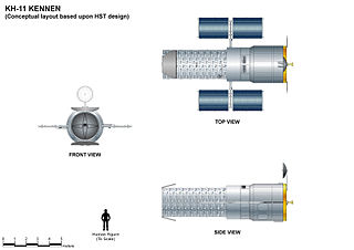
The KH-11 KENNEN is a type of reconnaissance satellite first launched by the American National Reconnaissance Office (NRO) in December 1976. Manufactured by Lockheed in Sunnyvale, California, the KH-11 was the first American spy satellite to use electro-optical digital imaging, and so offer real-time optical observations.

The SAMOS or SAMOS-E program was a relatively short-lived series of reconnaissance satellites for the United States in the early 1960s, also used as a cover for the initial development of the KH-7 GAMBIT system. Reconnaissance was performed with film cameras and television surveillance from polar low Earth orbits with film canister returns and transmittals over the United States. SAMOS was first launched in 1960 from Vandenberg Air Force Base.
The Aerospace Corporation is an American nonprofit corporation that operates a federally funded research and development center (FFRDC) in El Segundo, California. The corporation provides technical guidance and advice on all aspects of space missions to military, civil, and commercial customers. As the FFRDC for national-security space, Aerospace works closely with organizations such as the United States Space Force (USSF) and the National Reconnaissance Office (NRO) to provide "objective technical analyses and assessments for space programs that serve the national interest". Although the USSF and NRO are the primary customers, Aerospace also performs work for civil agencies such as NASA and NOAA as well as international organizations and governments in the national interest.

Before the Apollo 11 Moon landing in 1969, NASA began studies of Space Shuttle designs as early as October 1968. The early studies were denoted "Phase A", and in June 1970, "Phase B", which were more detailed and specific. The primary intended use of the Phase A Space Shuttle was supporting the future space station, ferrying a minimum crew of four and about 20,000 pounds (9,100 kg) of cargo, and being able to be rapidly turned around for future flights, with larger payloads like space station modules being lifted by the Saturn V.
Future Imagery Architecture (FIA) was a program awarded to Boeing to design a new generation of optical and radar imaging US reconnaissance satellites for the National Reconnaissance Office (NRO). In 2005 NRO director Donald Kerr recommended the project's termination, and the optical component of the program was finally cancelled in September 2005 by Director of National Intelligence John Negroponte. FIA has been called by The New York Times "perhaps the most spectacular and expensive failure in the 50-year history of American spy satellite projects." Despite the optical component's cancellation, the radar component, known as Topaz, has continued, with four satellites in orbit as of February 2016.

KH-9, commonly known as Big Bird or KeyHole-9, was a series of photographic reconnaissance satellites launched by the United States between 1971 and 1986. Of twenty launch attempts by the National Reconnaissance Office, all but one were successful. Photographic film aboard the KH-9 was stored on RCA Astro Electronic Division take up reel system then sent back to Earth in recoverable film return capsules for processing and interpretation. The highest ground resolution achieved by the main cameras of the satellite was 2 ft (0.61 m), though another source says "images in the "better-than-one-foot" category" for the last "Gambit" missions.

Itek Corporation was a United States defense contractor that initially specialized in camera systems for spy satellites and various other reconnaissance systems. In the early 1960s they built a conglomerate in a fashion similar to LTV or Litton, during which time they developed the first CAD system and explored optical disc technology. These efforts were unsuccessful, and the company shed divisions to various companies, returning to its roots in the reconnaissance market. The remaining portions were eventually purchased by Litton in 1983, and then Hughes, Raytheon, and Goodrich Corporation.

Alexander Henry Flax was the Chief Scientist of the U.S. Air Force (USAF) from 1959 to 1961, Assistant Secretary of the Air Force for Research and Development from 1963 to 1969, and the third Director of the National Reconnaissance Office (NRO) from 1965 to 1969. He was the director at a time when the second generation of imaging systems became operational and began to play a major role in United States intelligence during the Cold War. He oversaw major growth in NRO funding and personnel, the development of signals intelligence collectors from space, and the development of electro-optical imaging for US reconnaissance satellites.

Joseph Vincent Charyk was widely credited as the founder of the geosynchronous communications satellite industry. He was born in Canmore, Alberta to a Ukrainian family. Early in his career, Charyk consolidated the Central Intelligence Agency, United States Air Force, and United States Navy space programs into the National Reconnaissance Office (NRO). He brought the first United States imagery satellite, CORONA, into operation and demonstrated signals intelligence technology from space. During his tenure, the NRO operated the U-2 reconnaissance aircraft and managed development of the A-12.
The United States' National Reconnaissance Office's Program A was a component of the National Reconnaissance Program (NRP). Program A took the remnants of the Air Force Office of Special Projects (the successor to the ill-fated SAMOS program office, and redesignated it and refocused its efforts onto the next generation of imagery intelligence gathering satellites.

Discoverer 4, also known as Corona 9001, was an American optical reconnaissance satellite launched on 25 Jun 1959 at 22:47:45 GMT, the first of ten operational flights of the Corona KH-1 spy satellite series, and the first satellite to be equipped for photo surveillance. The satellite was not successfully orbited. Its loss spurred improvements of its rocket booster to ensure the success of subsequent missions.
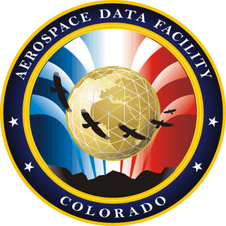
Aerospace Data Facility-Colorado (ADF-C) or Space Delta 20 one of three satellite ground stations operated by the National Reconnaissance Office (NRO) and United States Space Force in the continental United States. Located within Buckley Space Force Base in Aurora, Colorado, the facility is responsible for the command and control of reconnaissance satellites involved in the collection of intelligence information and for the dissemination of that intelligence to other U.S. government agencies.
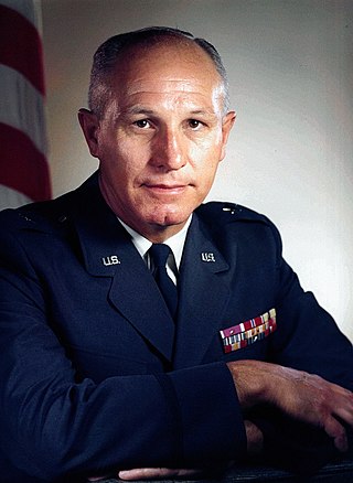
William Gregg King Jr. was a brigadier general in the United States Air Force (USAF). After service with the United States Army in World War II, he joined the USAF in 1947. He helped establish the Eastern Test Range at Cape Canaveral, Florida, was project officer for the SM-62 Snark cruise missile, helped initiate the WS-117L military satellite program, worked on the SAMOS reconnaissance satellite, commanded the Air Force Satellite Control Facility, and was director of the National Reconnaissance Office (NRO) Project A.
