The National Oceanic and Atmospheric Administration is an American scientific and regulatory agency charged with forecasting weather, monitoring oceanic and atmospheric conditions, charting the seas, conducting deep-sea exploration, and managing fishing and protection of marine mammals and endangered species in the US exclusive economic zone. The agency is part of the United States Department of Commerce and is headquartered in Silver Spring, Maryland.

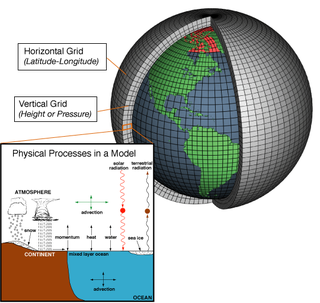
Numerical weather prediction (NWP) uses mathematical models of the atmosphere and oceans to predict the weather based on current weather conditions. Though first attempted in the 1920s, it was not until the advent of computer simulation in the 1950s that numerical weather predictions produced realistic results. A number of global and regional forecast models are run in different countries worldwide, using current weather observations relayed from radiosondes, weather satellites and other observing systems as inputs.

The Finnish Meteorological Institute is the government agency responsible for gathering and reporting weather data and forecasts in Finland. It is a part of the Ministry of Transport and Communications but it operates semi-autonomously.

Oceanic and Atmospheric Research (OAR) is a division of the National Oceanic and Atmospheric Administration (NOAA). OAR is also referred to as NOAA Research.
The National Severe Storms Laboratory (NSSL) is a National Oceanic and Atmospheric Administration (NOAA) weather research laboratory under the Office of Oceanic and Atmospheric Research. It is one of seven NOAA Research Laboratories (RLs).
The Cooperative Institute for Severe and High-Impact Weather Research and Operations (CIWRO) is one of 16 NOAA Cooperative Institutes (CIs), hosted at the University of Oklahoma. Before Oct. 1, 2021, it was known as the Cooperative Institute for Mesoscale Meteorological Studies (CIMMS). The CIMMS/CIWRO, a research organization created in 1978 by a cooperative agreement between the University of Oklahoma (OU) and the National Oceanic and Atmospheric Administration (NOAA), promotes collaborative research between NOAA and OU scientists on problems of mutual interest to improve basic understanding of mesoscale meteorological phenomena, weather radar, and regional climate to help produce better forecasts and warnings that save lives and property. CIMMS/CIWRO research contributes to the NOAA mission through improvement of the observation, analysis, understanding, and prediction of weather elements and systems and climate anomalies ranging in size from cloud nuclei to multi-state areas.

The Cooperative Institute for Research in Environmental Sciences (CIRES) is a research institute that is sponsored jointly by the National Oceanic and Atmospheric Administration (NOAA) Office of Oceanic and Atmospheric Research (OAR) and the University of Colorado Boulder (CU). CIRES scientists study the Earth system, including the atmosphere, hydrosphere, cryosphere, biosphere, and geosphere, and communicate these findings to decision makers, the scientific community, and the public.

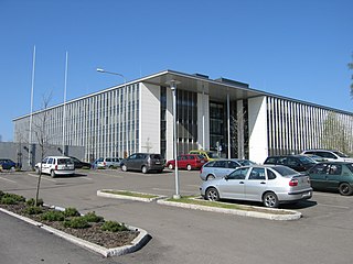
The Earth System Research Laboratories (ESRL) is an alliance of four NOAA scientific labs, all located in the David Skaggs Research Center on the Department of Commerce campus in Boulder, Colorado. Organized under NOAA's Office of Oceanic and Atmospheric Research, ESRL's main goal is to advance the scientific understanding of weather, climate, air quality, water resources, and other Earth system components.

The National Centre of Scientific Research "Demokritos" is a research center in Greece, employing over 1,000 researchers, engineers, technicians and administrative personnel. It focuses on several fields of natural sciences and engineering and hosts laboratory facilities.

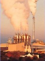
Atmospheric dispersion modeling is the mathematical simulation of how air pollutants disperse in the ambient atmosphere. It is performed with computer programs that include algorithms to solve the mathematical equations that govern the pollutant dispersion. The dispersion models are used to estimate the downwind ambient concentration of air pollutants or toxins emitted from sources such as industrial plants, vehicular traffic or accidental chemical releases. They can also be used to predict future concentrations under specific scenarios. Therefore, they are the dominant type of model used in air quality policy making. They are most useful for pollutants that are dispersed over large distances and that may react in the atmosphere. For pollutants that have a very high spatio-temporal variability and for epidemiological studies statistical land-use regression models are also used.

The Air Quality Modeling Group (AQMG) is in the U.S. EPA's Office of Air and Radiation (OAR) and provides leadership and direction on the full range of air quality models, air pollution dispersion models and other mathematical simulation techniques used in assessing pollution control strategies and the impacts of air pollution sources.
This page is out of date and should be considered an historic reference only
The Atmospheric Dispersion Modelling Liaison Committee (ADMLC) is composed of representatives from government departments, agencies and private consultancies. The ADMLC's main aim is to review current understanding of atmospheric dispersion and related phenomena for application primarily in the authorization or licensing of pollutant emissions to the atmosphere from industrial, commercial or institutional sites.
The National Atmospheric Release Advisory Center (NARAC) is located at the University of California's Lawrence Livermore National Laboratory. It is a national support and resource center for planning, real-time assessment, emergency response, and detailed studies of incidents involving a wide variety of hazards, including nuclear, radiological, chemical, biological, and natural emissions.
Air stagnation is a meteorological condition that occurs when there is a lack of atmospheric movement, leading to the accumulation of pollutants and particles that can decline the air quality in a particular region. This condition typically correlates with air pollution and poor air quality due to the possible health risks it can cause to humans and the environment. Due to light winds and lack of precipitation, pollutants cannot be cleared from the air, either gaseous or particulate.
The following outline is provided as an overview of and topical guide to air pollution dispersion: In environmental science, air pollution dispersion is the distribution of air pollution into the atmosphere. Air pollution is the introduction of particulates, biological molecules, or other harmful materials into Earth's atmosphere, causing disease, death to humans, damage to other living organisms such as food crops, and the natural or built environment. Air pollution may come from anthropogenic or natural sources. Dispersion refers to what happens to the pollution during and after its introduction; understanding this may help in identifying and controlling it.

The Czech Hydrometeorological Institute is the central state office of the Czech Republic in the fields of air quality, meteorology, climatology and hydrology. It is an organization established by the Ministry of the Environment of the Czech Republic. The head office and centralized workplaces of the CHMI, including the data processing, telecommunication and technical services, are located at the Institute's own campus in Prague.

The history of numerical weather prediction considers how current weather conditions as input into mathematical models of the atmosphere and oceans to predict the weather and future sea state has changed over the years. Though first attempted manually in the 1920s, it was not until the advent of the computer and computer simulation that computation time was reduced to less than the forecast period itself. ENIAC was used to create the first forecasts via computer in 1950, and over the years more powerful computers have been used to increase the size of initial datasets and use more complicated versions of the equations of motion. The development of global forecasting models led to the first climate models. The development of limited area (regional) models facilitated advances in forecasting the tracks of tropical cyclone as well as air quality in the 1970s and 1980s.
The Hybrid Single-Particle Lagrangian Integrated Trajectory model (HYSPLIT) is a computer model that is used to compute air parcel trajectories to determine how far and in what direction a parcel of air, and subsequently air pollutants, will travel. HYSPLIT is also capable of calculating air pollutant dispersion, chemical transformation, and deposition. The HYSPLIT model was developed by the National Oceanic and Atmospheric Administration (NOAA) Air Resources Laboratory and the Australian Bureau of Meteorology Research Centere in 1998. The model derives its name from the usage of both Lagrangian and Eulerian approaches.


