Przekop, , in Poland, is a branch of the Vistula river in its delta. It is also called Przekop Wisły, which translates literally from Polish as Vistula Dug-through.
Kootanae House, also spelled Kootenae House, was a North West Company fur trading post built by Jaco Finlay under the direction of David Thompson near present-day Invermere, British Columbia in 1807. It was abandoned in 1812. In 1808 Thompson reckoned its location as 50°32′12″N115°56′15″W. The actual location is Kootenae House National Historic Site, located at 50.526624°N 116.045440°W.
Wester Broom is a district of Edinburgh, Scotland. It borders Broomhouse/Forrester, Corstorphine and South Gyle. It is sometimes considered to be part of one of the latter two. It is mainly residential, with a few small shops and a large Tesco nearby. The Fife railway line is arguably the boundary, although some will extend it south to the Glasgow line, and to include Forresters and two schools.
Homathko Estuary Provincial Park is a provincial park in British Columbia, Canada, located at the head of Bute Inlet surrounding the mouth of the Homathko River in the Pacific Ranges of the Coast Mountains.
The South Branch of the Baker River is a 15.6-mile-long (25.1 km) river located in western New Hampshire in the United States. It is a tributary of the Baker River, part of the Pemigewasset River and Merrimack River watersheds.
Randolph, formerly called Roanoke and Talcott, is a small unincorporated community in Charlotte County, Virginia, United States, near the Staunton River. Its elevation is 354 feet. The community is the home of Staunton River Battlefield State Park.

Ilene is an unincorporated community in Washington Township, Greene County, Indiana.
The Deyma is a river in Russia's Kaliningrad Oblast. It separates from the Pregolya at Gvardeysk, flows through Polessk, and ends at the Curonian Lagoon. The Polessk Canal connects the Deima with the Nemunas.

Borowe is a village in the administrative district of Gmina Narewka, within Hajnówka County, Podlaskie Voivodeship, in north-eastern Poland, close to the border with Belarus. It lies approximately 10 kilometres (6 mi) north-east of Narewka, 27 km (17 mi) north-east of Hajnówka, and 54 km (34 mi) south-east of the regional capital Białystok.
Kotłówka is a village in the administrative district of Gmina Żelechów, within Garwolin County, Masovian Voivodeship, in east-central Poland. It lies approximately 3 kilometres (2 mi) east of Żelechów, 24 km (15 mi) south-east of Garwolin, and 80 km (50 mi) south-east of Warsaw.
Nowa Wieś is a village in the administrative district of Gmina Krasne, within Przasnysz County, Masovian Voivodeship, in east-central Poland. It lies approximately 13 kilometres (8 mi) south of Przasnysz and 78 km (48 mi) north of Warsaw.
Kamienicki Młyn is a village in the administrative district of Gmina Sierakowice, within Kartuzy County, Pomeranian Voivodeship, in northern Poland. It lies approximately 7 kilometres (4 mi) north of Sierakowice, 22 km (14 mi) west of Kartuzy, and 49 km (30 mi) west of the regional capital Gdańsk.
Wrząckie is a settlement in the administrative district of Gmina Kobylnica, within Słupsk County, Pomeranian Voivodeship, in northern Poland. It lies approximately 12 kilometres (7 mi) south-west of Kobylnica, 15 km (9 mi) south-west of Słupsk, and 113 km (70 mi) west of the regional capital Gdańsk.
Redystowo is a village in the administrative district of Gmina Łęczyce, within Wejherowo County, Pomeranian Voivodeship, in northern Poland. It lies approximately 8 kilometres (5 mi) south of Łęczyce, 25 km (16 mi) west of Wejherowo, and 52 km (32 mi) west of the regional capital Gdańsk.
Kuty is a village in the administrative district of Gmina Pozezdrze, within Węgorzewo County, Warmian-Masurian Voivodeship, in northern Poland. It lies approximately 7 kilometres (4 mi) north-east of Pozezdrze, 14 km (9 mi) east of Węgorzewo, and 104 km (65 mi) north-east of the regional capital Olsztyn.

Kukulovce is a village in the municipality of Leskovac, Serbia. According to the 2002 census, the village had a population of 298 people.
Tobacco is an unincorporated community located in Brunswick County, in the U.S. state of Virginia.
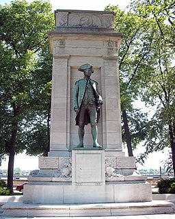
American Revolution Statuary is a group of fourteen statues in Washington, D.C., listed with the National Register of Historic Places. The statues are scattered across Washington, mainly in squares and traffic circles, with four statues of European officers displayed in Lafayette Square, across from the White House

The Civil War Monuments in Washington, D.C. are a group of eighteen outdoor statues which are spread out through much of central and northwest Washington, D.C. The statues depict 11 Union generals and one Confederate general, Albert Pike, who is depicted as a Mason rather than a military man. Two Union admirals are honored, although Admiral Samuel Francis DuPont's statue was removed to Wilmington, Delaware, and he is now honored with a fountain. Other statues depict nuns, peace, emancipation, and the Grand Army of the Republic.
Indian Creek is a stream in northeast Dallas County, Missouri. It is a tributary of the Niangua River.