
Cobb County is a county in the U.S. state of Georgia, located in the Atlanta metropolitan area in the north central portion of the state. As of 2020 Census, the population was 766,149. It is the state's third most populous county, after Fulton and Gwinnett counties. Its county seat is Marietta; its largest city is Mableton.

The Chattahoochee River forms the southern half of the Alabama and Georgia border, as well as a portion of the Florida and Georgia border. It is a tributary of the Apalachicola River, a relatively short river formed by the confluence of the Chattahoochee and Flint rivers and emptying from Florida into Apalachicola Bay in the Gulf of Mexico. The Chattahoochee River is about 430 miles (690 km) long. The Chattahoochee, Flint, and Apalachicola rivers together make up the Apalachicola–Chattahoochee–Flint River Basin. The Chattahoochee makes up the largest part of the ACF's drainage basin.

The Battle of Peachtree Creek was fought in Georgia on July 20, 1864, as part of the Atlanta Campaign in the American Civil War. It was the first major attack by Lt. Gen. John Bell Hood since taking command of the Confederate Army of Tennessee. The attack was against Maj. Gen. William T. Sherman's Union army, which was perched on the doorstep of Atlanta. The main armies in the conflict were the Union Army of the Cumberland, commanded by Maj. Gen. George Henry Thomas and two corps of the Confederate Army of Tennessee.

Brandywine Creek is a tributary of the Christina River in southeastern Pennsylvania and northern Delaware in the United States. The Lower Brandywine is 20.4 miles (32.8 km) long and is a designated Pennsylvania Scenic River with several tributary streams. The East Branch and West Branch of the creek originate within 2 miles (3 km) of each other on the slopes of Welsh Mountain in Honey Brook Township, Pennsylvania, about 20 miles (32 km) northwest of their confluence.
Standing Peachtree was a Muscogee village and the closest Indian settlement to what is now the Buckhead area of Atlanta, Georgia. It was located where Peachtree Creek flows into the Chattahoochee River, in today's Paces neighborhood. It was located in the borderlands of the Cherokee and Muscogee nations. It is referred to in several documents dating as far back as 1782.
There were several historic mills around the metro Atlanta area, for which many of its current-day roads are still named. Most of the mills date back to the 1820s and 1830s, and were built along the area's many streams. The locations of many of these mills are shown on a map of 1875 showing U. S. military operations around Atlanta in 1864. This map is now located in the U. S. Library of Congress but can be seen on the webpage linked here.

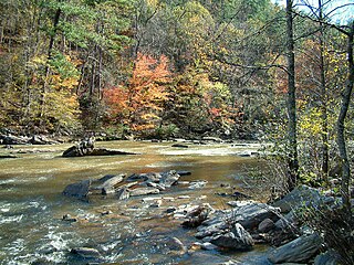
Sope Creek is an 11.6-mile-long (18.7 km) stream located in Cobb County, Georgia, United States. It is a significant tributary of the Chattahoochee River. It was known as Soap Creek during the 19th century. A section of Sope Creek runs through the Chattahoochee River National Recreation Area.

Peachtree Creek is a major stream in Atlanta. It flows for 7.5 miles (12.1 km) almost due west into the Chattahoochee River just south of Vinings.
Sweetwater Creek is a 45.6-mile-long (73.4 km) stream in the U.S. state of Georgia, west of Atlanta. It begins in southwestern Paulding County, flowing generally eastward into southwestern Cobb County, then turning south into eastern Douglas County. It is a tributary of the Chattahoochee River, and near its end it is the centerpiece of Sweetwater Creek State Park.
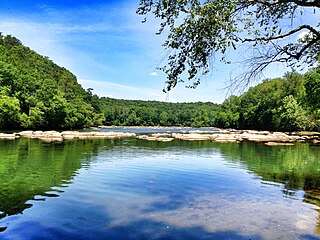
Chattahoochee River National Recreation Area (CRNRA) preserves a series of sites between Atlanta and Lake Sidney Lanier along the Chattahoochee River in Georgia, U.S. The 48-mile (77 km) stretch of the river affords public recreation opportunities and access to historic sites. The national recreation area, a National Park Service unit, was established on August 15, 1978, by President Jimmy Carter.
The Battle of Brown's Mill was fought July 30, 1864, in Coweta County, Georgia, during the Atlanta Campaign of the American Civil War. Edward M. McCook's Union cavalry, on a daring raid to sever communications and supply lines in south-central Georgia, was defeated near Newnan, Georgia, by Confederate forces under Joseph Wheeler. The failure of McCook's column and a concurrent ill-fated raid by George Stoneman forced William T. Sherman to lay siege to the city of Atlanta.
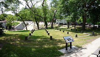
The Edina Mill was one of the first of six gristmills to be built on the Minnehaha Creek in Hennepin County, Minnesota between 1855 and 1876. Located in present-day Edina, the mill site was discovered during an expedition from Fort Snelling to Lake Minnetonka in 1822. Although the original mill structure was demolished in 1932, its former site is preserved with foundation markers and informational exhibits.
Powers Park is an unincorporated community located east-southeast of Marietta in Cobb County, Georgia, United States.

Price's Mill, also known as Calliham's (Callaham's) Mill, Stone's Mill, and Park's Mill, is a water-powered gristmill about 2 mi (3 km) east of the town of Parksville on South Carolina Highway 33-138 at Stevens Creek in McCormick County. Its name in the USGS Geographic Names Information System is Prices Mill. It was built in the 1890s and was named to the National Register of Historic Places on November 22, 1972. At this time, it was one of the few remaining water-powered gristmills in South Carolina.

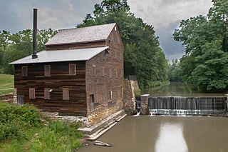
The Newlin Mill Complex, also referred to as The Newlin Grist Mill, is a water-powered gristmill on the west branch of Chester Creek near Concordville, Pennsylvania built in 1704 by Nathaniel and Mary Newlin and operated commercially until 1941. During its three centuries of operation, the mill has been known as the Lower Mill, the Markham Mill, the Seventeen-O-Four Mill and the Concord Flour Mill. In 1958 the mill property was bought by E. Mortimer Newlin, restored and given to the Nicholas Newlin Foundation to use as a historical park. Water power is still used to grind corn meal which is sold on site. The park includes five historical buildings, which were added to the National Register of Historic Places in 1983, and 150 acres (61 ha) of natural woodland.
Paces is a neighborhood of Atlanta, US. It is part of the Buckhead district and located in the far northwest corner of the city. Paces is bounded on the northwest by the Chattahoochee River, which is also the Cobb/Fulton county line. Just across the river in Cobb is the unincorporated community of Vinings, which was originally known as Paces after founder Hardy Pace, who operated Pace's Ferry. Cumberland is also located on the other side of the river. It is perhaps Atlanta's most affluent neighborhood, with many houses selling in the US$5–$7 million range, and some for more than $20 million.
Pine Creek Gristmill is a historic building located in Wildcat Den State Park in Muscatine County, Iowa, United States. The building was listed on the National Register of Historic Places in 1979.

Benson Grist Mill is a restoration-replica museum located in Tooele County, Utah in the western United States, which allows visitors to see the inner workings of a latter-nineteenth-century pioneer gristmill. It has four other historic (nineteenth-century) buildings which have been moved onto the site, as well as four ancillary structures, including an open-air pavilion. It covers 6.98 acres along State Highway 138, 0.8 mile southwest of the intersection of the Road with State Highway 36. The museum is owned and operated by a division of Tooele County.
Rottenwood Creek is a stream in Cobb County in the U.S. state of Georgia. It is a tributary to the Chattahoochee River.

