
Bærum is a municipality in Akershus County, Norway. The administrative centre of the municipality is the town of Sandvika. Bærum was established as a municipality on 1 January 1838. A suburb of Oslo, Bærum is located on the west coast of the city.
Romsås is a neighborhood in the city of Oslo, Norway. Located northeast of Groruddalen, at the edge of Lillomarka, Romsås was formerly its own borough but was merged into the larger borough of Grorud on January 1, 2004. The name Romsås originated with the Romsås farm which by 1850 was one of the biggest farms in Østre Aker.

Ekebergsletta is a field in the neighborhood of Ekeberg in the Nordstrand district, southeast of downtown Oslo, Norway.
Yven is a borough in the city of Sarpsborg in Østfold, Norway. It is located east of the city centre on the west side of the Glomma river between Sarpsborg and Fredrikstad. Yven was previously assigned to the former municipality of Tune. As of 1885, the village was estimated to have had 297 inhabitants.

Slemmestad is a village in Røyken municipality, Norway. Slemmestad is located on the Oslofjord, west of Oslo, Norway.

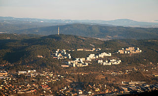
Kolsås is a wooded mountain ridge in the municipality of Bærum, Norway. Geologically, Kolsås belongs to the Oslo Graben area. Its two peaks consist of hard rhomb porphyric lava covering softer rocks, forming steep cliffs to the east, south and west.
Bjølsen is a neighbourhood in the Sagene borough in central-northern Oslo, Norway. Originally a farm in the former Aker municipality, it was incorporated into Christiania in 1878.

The Barcode Project is a section of the Bjørvika portion of the Fjord City redevelopment on former dock and industrial land in central Oslo. It consists of a row of new multi-purpose high-rise buildings, that was completed in 2016. The developer is marketing the project as "The Opera Quarter." There has been intense public debate about the height and shape of the buildings.

Hasle is a neighborhood in the borough of Grünerløkka in Oslo, Norway.

Hovseter is a neighbourhood of Oslo, Norway, that comes under Vestre Aker kommune and lies between Røa and Holmen.
Håøya is an island in Oslofjorden in Frogn municipality, Norway.
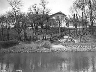
Berg is a neighbourhood in the North End of Oslo. It is located in the borough Nordre Aker, and is surrounded by the neighbourhoods Nordberg in the north, Tåsen in the east and Ullevål Hageby in the southwest. Berg is named after an abandoned farm with the same name. Berg is mainly a residential area, and is served by the station Berg on the Sognsvann Line.
Einar Gerhardsens plass is a town square between the three government buildings S Block, R4, and Høyblokka in Regjeringskvartalet in Oslo. The street Grubbegata passes through the square.

Langøyene is an island in Bunnefjorden in the inner part of Oslofjord, in the municipitality of Nesodden in Akershus, Norway. It is owned by the municipality of Oslo. Langøyene were originally two islands, Nordre Langøy and Søndre Langøy. The islands were bought by the municipitality of Kristiania in 1902, and the strait between the two islands has been filled with garbage deposits.
Bleikøya is an island in the inner part of Oslofjord, in the municipitality of Oslo. It is located between Hovedøya and Sjursøya. From the late 19th century a sanatorium for children suffering from scrofula was located on the island.
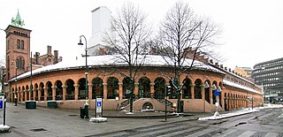
Oslo Bazaars are located at Oslo Cathedral, along the streets Karl Johans gate and Dronningens gate in Oslo, Norway. The buildings of the bazaar constitute a continuous facility that encircles three sides of the quarter with Oslo Cathedral.
Økern was a farm in the former municipality of Aker, Norway, and is currently a district in the borough of Bjerke in the city of Oslo. It includes the neighborhoods of Refstad, Risløkka, Brobekk, Nordre Hovin, Aker Sykehus, Bjerkebanen, and Økern Senter.

Furuset Aktivitetspark is a park in the neighborhood of Furuset in Oslo, Norway. It opened in November 2008. It was created as part of an initiative to develop the Grorud Valley under the auspices of Oslo Municipality and the national authorities.

Sommerroparken, formerly known as Solliparken, is a small park between the streets of Sommerrogata and Henrik Ibsens Gate in the Frogner district of Oslo, Norway. It consists of a narrow grass-covered strip with park benches, ornaments, trees and bushes.

Oslo Port Authority is a kommunalt foretak, and accountable to the Municipality of Oslo. For many years, Oslo Havn KF was known as Oslo havnevesen (OHV) but was renamed on June 8, 2004, to its current name.


