Related Research Articles
The Kaduna River is a tributary of the Niger River which flows for 550 kilometres (340 mi) through Nigeria. It got its name from the crocodiles that lived in the river and surrounding area. Kaduna in the native dialect, Hausa, was the word for "crocodiles". It starts in Plateau State on the Jos Plateau 29 kilometres (18 mi) southwest of Jos town, flows through its namesake Kaduna State and through its capital Kaduna, and meets the Niger River in Niger State. Most of its course passes through open savanna woodland, but its lower section has cut several gorges above its entrance into the extensive Niger floodplains. The river is used for fishing and transport of local produce.
Yenagoa is a Local Government Area and capital city of Bayelsa State, Southern Nigeria. It is located at the Niger-Delta region of the country at coordinates 4°55′29″N6°15′51″E.
Ogoja is a Local Government Area in Cross River State, Nigeria. Its headquarters is Ogoja town in the northeast of the area near the A4 highway at 6°39′17″N8°47′51″E.

Jalingo is the capital city of Taraba State in north-eastern Nigeria, named in fulfulde and has been estimated with population of 418,000 as of 2018, The city has received the highest number of immigrants mainly from, Kano, Borno, Gombe and the neighboring Cameroon. As of November, 2022 the city is estimated to have around 581,000 people.

Oguta Lake is a lean 'finger lake' formed by the damming of the lower Njaba River with alluvium. it is the largest natural lake in Imo State, Southeastern Nigeria; within the equatorial rainforest region of Niger Delta. Oguta Lake's catchment area comprises the drainage area of the Njaba River and a part of the River Niger floodplain in the region south of Onitsha.
Ikere-Ekiti, also known as Ikere or Ikerre, is a city in Ekiti State of Nigeria. It is an agricultural and mine centre. According to the 1963 and 1991 census, the population was 114,780 and 60,257 respectively, but the 2006 census recorded it to be 147,355.
Bende is a Local Government Area in Abia State, Nigeria with headquarters located in Bende Community. Bende Local Government Area (L.G.A) of Abia state lies on 70 30I of the Greenwich Meridian and latitude 50 30I North of the Equator. It is composed of thirteen (13) communities, namely: Alayi, Bende, Ezukwu, Igbere, Item, Itumbuzo, Nkpa, Ntalakwu, Ozuitem, Ugwueke, Umu-imenyi, Umuhu-Ezechi, and Uzuakoli.
Gummi is a Local Government Area in Zamfara State, Nigeria. Its headquarters is in the town of Gummi at12°08′30″N5°07′30″E .
Ankpa is a Local Government Area in Kogi State, Nigeria. Its headquarters are in the town of Ankpa on the A233 highway in the west of the area at 7°22′14″N7°37′31″E.
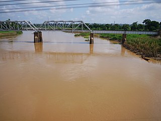
Ahoada West is a Local Government Area of Rivers State, Nigeria, located Northwest of Port Harcourt. It was extracted in 1996 in the General Sani Abacha military regime from the old Ahoada Local Government that makes up the present Orashi Region of Rivers State. Its seat is in the town of Akinima.

Akko is a local government area of Gombe, Gombe State, Nigeria. Its headquarters is in Kumo town on the A345 highway south of the state capital Gombe, about 40 km away. Kumo (headquarter) is a cosmopolitan communities of more than 30 differents tribes, ranging from the dominant Fulani tribe to Tangale, Tera, Hausa and other minorities.

Keffi Local Government Area and a traditional and commercial town in Nasarawa State, north central Nigeria. Its headquarters are in the town of Keffi. Keffi is 50 kilometers from Abuja. Nasarawa State university is located along the Keffi-Akwanga expressway.
Anka is a Local Government Area in Zamfara State, Nigeria. Its headquarters is in the town of Anka at 12°06′30″N5°56′00″E.
Tsafe is a Local Government Area L G A) in Zamfara State, Nigeria. Its headquarters is in the town of Chafe town. It shares boundaries with Gusau Local Government Area to the northwest, west, and south, while its northeastern and eastern borders connect with Katsina state. The local government council oversees public administration within the area, and its legislative council formulates laws that govern the local government jurisdiction.
Talata Mafara is a Local Government Area in Zamfara State, Nigeria. Its headquarters is in the town of Talata Mafara, about 15 km from the Bakolori Dam on the Sokoto River12°34′00″N6°04′00″E. The town lies on the southern edge of the major irrigation project fed by the dam. The town is the birthplace of Yahaya Abdulkarim, governor of Sokoto State from January 1992 to November 1993.
Birnin Magaji/Kiyaw is a Local Government Area in Zamfara State, Nigeria. Its headquarters are in the town of Birnin Magaji in the north of the LGA at12°33′00″N6°49′00″E. The LGA is also named from the town of Kiyaw to the south.
Fika is a Local Government Area in Yobe State, Nigeria. Its headquarters are in the town of Fika in the south of the area at 11°17′00″N11°18′29″E.
Fika is a Local Government Area in Yobe State, Nigeria. Its headquarters are in the town of Fika in the south of the area at 11°17′00″N11°18′29″E.
Ife South is a Local Government Area in Osun State, Nigeria. Its headquarters are in the town of Ifetedo at 7°11′00″N4°42′00″E.
Ede North is a Local Government Area in Osun State, Nigeria. Its headquarters as Abere.
References
- 1 2 "Ahoada West LGA". www.finelib.com. Retrieved 2023-04-30.
- ↑ "Lulu-Briggs Foundation Donates N60m Relief Items To Rivers' Flood Victims". 2022-11-11. Retrieved 2023-04-30.
- ↑ "Akinima Climate, Weather By Month, Average Temperature (Nigeria) - Weather Spark". weatherspark.com. Retrieved 2023-09-24.
5°05′17″N6°28′10″E / 5.08806°N 6.46944°E
| | This article about a location in Rivers State, Nigeria is a stub. You can help Wikipedia by expanding it. |