
Cape Town is the second-most populous city in South Africa, after Johannesburg, and also the legislative capital of South Africa.

The Province of the Cape of Good Hope, commonly referred to as the Cape Province and colloquially as The Cape, was a province in the Union of South Africa and subsequently the Republic of South Africa. It encompassed the old Cape Colony, as well as Walvis Bay, and had Cape Town as its capital. In 1994, the Cape Province was split up to form the new Eastern Cape, Northern Cape and Western Cape provinces, along with part of the North West.

Coloureds are a multiracial ethnic group native to Southern Africa who have ancestry from more than one of the various populations inhabiting the region, including Khoisan, Bantu, European, Austronesian, South Asian or East Asian. Because of the combination of ethnicities, different families and individuals within a family may have a variety of different physical features. Coloured was a legally defined racial classification during apartheid.

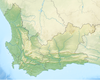
The Western Cape is a province of South Africa, situated on the south-western coast of the country. It is the fourth largest of the nine provinces with an area of 129,449 square kilometres (49,981 sq mi), and the third most populous, with an estimated 7 million inhabitants in 2020. About two-thirds of these inhabitants live in the metropolitan area of Cape Town, which is also the provincial capital. The Western Cape was created in 1994 from part of the former Cape Province. The two largest cities are Cape Town and George.
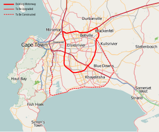
The N21 is a national route in South Africa in Cape Town. It mainly forms the Peninsula Expressway ring road. It links the northern suburbs on the Atlantic seaboard with the southern suburbs on False Bay. Known as the N21. Currently the ring road is partly complete with most of the road being a Dual carriageway, with parts of the N1 and N2 and N7 being a dual 4 lane freeway.

The N1 is a national route in South Africa that runs from Cape Town through Bloemfontein, Johannesburg, Pretoria and Polokwane to Beit Bridge on the border with Zimbabwe. It forms the first section of the famed Cape to Cairo Road.
The R316 is a regional route in the Western Cape province of South Africa that connects Caledon to the northwest with Arniston to the southeast via Bredasdorp and Napier. It runs for 96 kilometres (60 mi) and maintains a south-easterly direction for most of its course.
The R326 is a regional route in the Western Cape province of South Africa that connects Stanford in the south-west to the N2 highway between Caledon and Riviersonderend to the north-east. It begins at an intersection with the R43 at Stanford and runs east up the valley of the Klein River and over the Akkedisberg Pass. Once over the pass it crosses the R316 and continues north-east to end at the N2 10 kilometres (6 mi) west of Riviersonderend.
The R353 is a Regional Route in South Africa that connects Leeu-Gamka with Brandvlei via Fraserburg and Williston.
The R355 is a Regional Route in South Africa that connects the R46 near Ceres with Springbok via Calvinia.

The R381 is a Regional Route in South Africa that connects the N1 at Beaufort West in the south with Loxton in the north.

The N12 is a national route in South Africa which runs from George through Beaufort West, Kimberley, Klerksdorp and Johannesburg to eMalahleni.
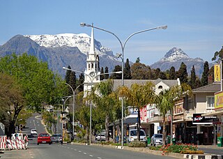
Wellington is a town in the Western Cape Winelands, a 45-minute drive from Cape Town, in South Africa with a population of approximately 62,000. Wellington's economy is centered on agriculture such as wine, table grapes, deciduous fruit, and a brandy industry. The town is located 75 km north-east of Cape Town, reached by the N1 motorway and R44. Due to the growth of the Mbekweni township south of the town, it now forms a de facto urban unit with Paarl, just 10 km to the south. Wellington now officially falls under the Drakenstein Local Municipality, which also covers Saron and Paarl.

The N9 is a national route in South Africa that connects George with the N1 at Colesberg, via Graaff-Reinet and Middelburg.
Salmonsdam Nature Reserve is a nature reserve in the Overberg region of the Western Cape province of South Africa. It contains the mountain catchment area of the Paardensberg River in the Akkedisberg mountains. The reserve is administered by CapeNature and covers an area of 834 hectares.
The Central Line is a commuter rail service in Cape Town, South Africa, operated by Metrorail Western Cape. Central Line services operate along two routes from central Cape Town to Langa, and then along three branches from Langa to various areas in the south-east of the city. The first branch runs to Mitchell's Plain, the second to Khayelitsha, and the third passes through Belhar to terminate in Bellville.

Wolseley is a small town in the upper Breede River Valley region of the Western Cape province of South Africa. In the 2011 Census it had a population of 1,528 people. It is located 90 kilometres (60 mi) northeast of Cape Town, in the Land van Waveren valley between the Waterval Mountains to the west and the Witzenberg Mountains to the east.

The economy of the Western Cape in South Africa is dominated by the city of Cape Town, which accounts for 72% of the Western Cape's economic activity in 2016. The single largest contributor to the region's economy is the financial and business services sector, followed by manufacturing. Close to 30% of the gross regional product comes from foreign trade with agricultural products and wine dominating exports. High-tech industries, international call centres, fashion design, advertising and TV production are niche industries rapidly gaining in importance.
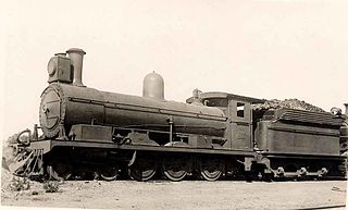
The Cape Government Railways 5th Class 4-6-0 of 1891 was a South African steam locomotive from the pre-Union era in the Cape of Good Hope.
The following index is provided as an overview of and topical guide to the protected areas of South Africa:
