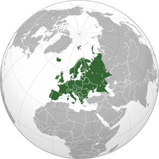
Europe is a continent located entirely in the Northern Hemisphere and mostly in the Eastern Hemisphere. It is bordered by the Arctic Ocean to the north, the Atlantic Ocean to the west, the Mediterranean Sea to the south, and Asia to the east. Europe shares the landmass of Eurasia with Asia, and of Afro-Eurasia with both Asia and Africa. Europe is commonly considered to be separated from Asia by the watershed of the Ural Mountains, the Ural River, the Caspian Sea, the Greater Caucasus, the Black Sea, and the waterway of the Bosporus Strait.

Luxembourg, officially the Grand Duchy of Luxembourg, is a small landlocked country in Western Europe. It is bordered by Belgium to the west and north, Germany to the east, and France to the south. Its capital and most populous city, Luxembourg, is one of the four institutional seats of the European Union and the seat of several EU institutions, notably the Court of Justice of the European Union, the highest judicial authority. Luxembourg's culture, people, and languages are highly intertwined with its French and German neighbours; while Luxembourgish is the only national language of the Luxembourgish people and of the Grand Duchy of Luxembourg, French is the only language for legislation, and all three – Luxembourgish, German and French – are used for administrative matters in the country.

Louisiana is a state in the Deep South and South Central regions of the United States. It borders Texas to the west, Arkansas to the north, and Mississippi to the east. Of the 50 U.S. states, it ranks 20th in land area and the 25th in population, with roughly 4.6 million residents. Reflecting its French heritage, Louisiana is the only U.S. state with political subdivisions termed parishes, which are equivalent to counties, making it one of only two U.S. states not subdivided into counties. Baton Rouge is the state's capital, and New Orleans, a French Louisiana region, is its largest city with a population of about 383,000 people. Louisiana has a coastline with the Gulf of Mexico to the south; a large part of its eastern boundary is demarcated by the Mississippi River.

Monaco, officially the Principality of Monaco, is a sovereign city-state and microstate on the French Riviera a few kilometres west of the Italian region of Liguria, in Western Europe, on the Mediterranean Sea. It is a semi-enclave bordered by France to the north, east and west. The principality is home to 38,682 residents, of whom 9,486 are Monégasque nationals; it is recognised as one of the wealthiest and most expensive places in the world. The official language is French; Monégasque, English and Italian are spoken and understood by many residents.

North America is a continent in the Northern and Western Hemispheres. North America is bordered to the north by the Arctic Ocean, to the east by the Atlantic Ocean, to the southeast by South America and the Caribbean Sea, and to the west and south by the Pacific Ocean. The region includes the Bahamas, Bermuda, Canada, the Caribbean, Central America, Clipperton Island, Greenland, Mexico, Saint Pierre and Miquelon, Turks and Caicos Islands, and the United States.

Nevada is a landlocked state in the Western region of the United States. It borders Oregon to the northwest, Idaho to the northeast, California to the west, Arizona to the southeast, and Utah to the east. Nevada is the 7th-most extensive, the 32nd-most populous, and the 9th-least densely populated of the U.S. states. Nearly three-quarters of Nevada's people live in Clark County, which contains the Las Vegas–Paradise metropolitan area, including three of the state's four largest incorporated cities. Nevada's capital is Carson City. Las Vegas is the largest city in the state.

New Caledonia is a sui generis collectivity of overseas France in the southwest Pacific Ocean, south of Vanuatu, about 1,210 km (750 mi) east of Australia, and 17,000 km (11,000 mi) from Metropolitan France. The archipelago, part of the Melanesia subregion, includes the main island of Grande Terre, the Loyalty Islands, the Chesterfield Islands, the Belep archipelago, the Isle of Pines, and a few remote islets. The Chesterfield Islands are in the Coral Sea. French people, especially locals, call Grande Terre le Caillou, a nickname also used more generally for the entire New Caledonia. Pro-independence Kanak parties use the name (la) Kanaky to refer to New Caledonia, a term coined in the 1980s from the ethnic name of the indigenous Melanesian Kanak people who make up 41% of New Caledonia's population. New Caledonia is one of the European Union's Overseas Countries and Territories (OCTs), but it is not part of the European Union.

South America is a continent entirely in the Western Hemisphere and mostly in the Southern Hemisphere, with a considerably smaller portion in the Northern Hemisphere. It can also be described as the southern subregion of the Americas.

Southeast Asia is the geographical south-eastern region of Asia, consisting of the regions that are situated south of China, east of the Indian subcontinent, and north-west of mainland Australia which is part of Oceania. Southeast Asia is bordered to the north by East Asia, to the west by South Asia and the Bay of Bengal, to the east by Oceania and the Pacific Ocean, and to the south by Australia and the Indian Ocean. Apart from the British Indian Ocean Territory and two out of 26 atolls of Maldives in South Asia, Maritime Southeast Asia is the only other subregion of Asia that lies partly within the Southern Hemisphere. Mainland Southeast Asia is entirely in the Northern Hemisphere. East Timor and the southern portion of Indonesia are the parts of Southeast Asia that lie south of the Equator.

Tajikistan, officially the Republic of Tajikistan, is a landlocked country in Central Asia. Dushanbe is the capital and most populous city. Tajikistan is bordered by Afghanistan to the south, Uzbekistan to the west, Kyrgyzstan to the north, and China to the east. It is separated from Pakistan by Afghanistan's Wakhan Corridor.

Uzbekistan, officially the Republic of Uzbekistan, is a doubly landlocked country located in Central Asia. It is surrounded by five countries: Kazakhstan to the north, Kyrgyzstan to the northeast, Tajikistan to the southeast, Afghanistan to the south, and Turkmenistan to the southwest, making it one of only two doubly landlocked countries on Earth, the other being Liechtenstein. Uzbekistan is part of the Turkic world, as well as a member of the Organization of Turkic States. Uzbek is the majority language, while Russian is widely spoken and understood. Islam is the predominant religion, and most Uzbeks are Sunni Muslims.
In the United States, a metropolitan statistical area (MSA) is a geographical region with a relatively high population density at its core and close economic ties throughout the region. Such regions are not legally incorporated as a city or town would be and are not legal administrative divisions like counties or separate entities such as states. As a result, sometimes the precise definition of a given metropolitan area will vary between sources. The statistical criteria for a standard metropolitan area were defined in 1949 and redefined as a metropolitan statistical area in 1983.

India is a federal union comprising 28 states and 8 union territories, for a total of 36 entities. The states and union territories are further subdivided into districts and smaller administrative divisions.

Guyana, officially the Co-operative Republic of Guyana, is a country on the northern coast of South America, part of the historic mainland British West Indies. Guyana is an indigenous word which means "Land of Many Waters". Georgetown is the capital of Guyana and is also the country's largest city. Guyana is bordered by the Atlantic Ocean to the north, Brazil to the south and southwest, Venezuela to the west, and Suriname to the east. With a land area of 214,969 km2 (83,000 sq mi), Guyana is the third-smallest sovereign state by area in mainland South America after Uruguay and Suriname, and is the second-least populous sovereign state in South America after Suriname; it is also one of the least densely populated countries on Earth. It has a wide variety of natural habitats and very high biodiversity. The country also hosts a part of the Amazon rainforest, the largest tropical rainforest in the world.
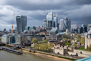
Greater London is the administrative area of London, England, which is coterminous with the London region. It contains 33 local government districts: the 32 London boroughs, which form a ceremonial county also called Greater London, and the City of London. The Greater London Authority is responsible for strategic local government across the region, and regular local government is the responsibility of the borough councils and the City of London Corporation. Greater London is bordered by the ceremonial counties of Hertfordshire to the north, Essex to the north-east, Kent to the south-east, Surrey to the south, and Berkshire and Buckinghamshire to the west.

