This article is being considered for deletion in accordance with Wikipedia's deletion policy. Please share your thoughts on the matter at this article's entry on the Articles for deletion page. Feel free to improve the article, but the article must not be blanked, and this notice must not be removed, until the discussion is closed. For more information, particularly on merging or moving the article during the discussion, read the guide to deletion. |
This article needs additional citations for verification .(September 2018) (Learn how and when to remove this template message) |
| Al Fara' | |
|---|---|
 Al Fara' | |
| Coordinates: 25°24′44″N56°5′23″E / 25.41222°N 56.08972°E Coordinates: 25°24′44″N56°5′23″E / 25.41222°N 56.08972°E | |
| Country | United Arab Emirates |
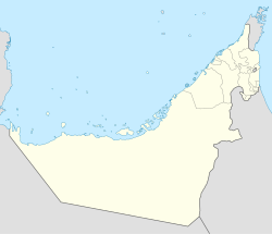
| Emirate | Ras al-Khaimah |
| Elevation | 532 m (1,748 ft) |
Al Fara' is the name of a settlement in Ras al-Khaimah, one of the seven emirates that make up the United Arab Emirates (UAE). [1] It is in a valley southeast of the emirate's main city, also known as Ras al-Khaimah or RAK city. [1]

The United Arab Emirates consists of seven emirates, which were historically known as the Trucial States:
The United Arab Emirates, sometimes simply called the Emirates, is a country in Western Asia at the southeast end of the Arabian Peninsula on the Persian Gulf, bordering Oman to the east and Saudi Arabia to the south, as well as sharing maritime borders with Qatar to the west and Iran to the north. The sovereign constitutional monarchy is a federation of seven emirates consisting of Abu Dhabi, Ajman, Dubai, Fujairah, Ras Al Khaimah, Sharjah and Umm Al Quwain. Their boundaries are complex, with numerous enclaves within the various emirates. Each emirate is governed by a ruler; together, they jointly form the Federal Supreme Council. One of the rulers serves as the President of the United Arab Emirates. In 2013, the UAE's population was 9.2 million, of which 1.4 million are Emirati citizens and 7.8 million are expatriates.
The settlement was affected by heavy regional flooding in 2014. [1]
