Al Jawf is a governorate of Yemen. Its capital is Al Hazm.
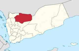
Amran District is a district of the 'Amran Governorate, Yemen. As of 2003, the district had a population of 96,375 inhabitants. The capital lies at `Amran.
As Sawd District (Arabic: مديرية السود) is a district of the 'Amran Governorate, Yemen. As of 2003, the district had a population of 25,892 inhabitants.
Iyal Surayh District is a district of the 'Amran Governorate, Yemen. As of 2003, the district had a population of 54,015 inhabitants.
Kharif District is a district of the 'Amran Governorate, Yemen. As of 2003, the district had a population of 45,977 inhabitants. On July 13, 2020, it is reported that the Houthi militia captured the last Jews of Yemen in the Kharif District.
Rakhyah District is a district of the Hadhramaut Governorate, Yemen. As of 2021, the district had a population of 13,466 inhabitants.
Sayun District is a district of the Hadhramaut Governorate, Yemen. As of 2003, the district had a population of 102,409 inhabitants.
Hawrah District is a district of the Hadhramaut Governorate, Yemen. As of 2003, the district had a population of 28,474 inhabitants.

Yabuth District is a district of the Hadhramaut Governorate, Yemen. As of 2021, the district had a population of 15,442 inhabitants.

Arhab District is a district of the Sana'a Governorate, Yemen. As of 2003, the district had a population of 90,038 inhabitants.
Bani Dhabyan District is a district of the Sana'a Governorate, Yemen. As of 2003, the district had a population of 16,262 inhabitants. As of 2023, it is one of the only districts controlled by tribal forces.
Bani Hushaysh District is a district in Sana'a Governorate, Yemen. As of 2003, the district had a population of 73,957 inhabitants. It's also famous for grape plantations.
Hamdan District is a district of the Sana'a Governorate, Yemen. As of 2003, the district had a population of 85,370 inhabitants. It is named after the ancient Yemeni tribe of Hamdan.
Sanhan and Bani Bahlul District is a district of the Sana'a Governorate, Yemen. Its seat is Sanhan. As of 2003, the district had a population of 400,399 inhabitants. The former President of Yemen Ali Abdullah Saleh comes from Beit al-Ahmar, which lies in Sanhan District.
Ar Rawdah District is a district of the Shabwah Governorate in Yemen. As of 2003, the district had a population of 27,371 inhabitants.
Arma District (Yemen) (Arabic: مديرية عرماء) is a district of the Shabwah Governorate in Yemen. As of 2003, the district had a population of 10,188 inhabitants.
Dhar District (Yemen) (Arabic: مديرية دهر) is a district of the Shabwah Governorate in Yemen. As of 2003, the district had a population of 9,927 people.
Mayfa'a District is a district of the Shabwah Governorate in Yemen. As of 2003, the district had a population of 41,597 inhabitants.
Rudum District is a district of the Shabwah Governorate, Yemen. As of 2003, the district had a population of 23,244 inhabitants.

Beeston Tor railway station was a minor station which served the Beeston Tor in Grindon, Staffordshire. The site is now part of the Manifold Way.
