
Sumter County is a county located in the west central portion of Alabama. At the 2020 census, the population was 12,345. Its county seat is Livingston. Its name is in honor of General Thomas Sumter of South Carolina. The University of West Alabama is in Livingston.

Selma is a city in and the county seat of Dallas County, in the Black Belt region of south central Alabama and extending to the west. Located on the banks of the Alabama River, the city has a population of 17,971 as of the 2020 census. About 80% of the population is African-American.

Gainesville is a town in Sumter County, Alabama, United States. Founded in 1832, it was incorporated in 1835. At the 2010 census the population was 208, down from 220. Confederate Lieutenant General Nathan Bedford Forrest surrendered his men near Gainesville on May 19, 1865, at the Civil War's end.
Livingston is a city in and the county seat of Sumter County, Alabama, United States and the home of the University of West Alabama. By an act of the state legislature, it was incorporated on January 10, 1835. At the 2010 census the population was 3,485, up from 3,297 in 2000. It was named in honor of Edward Livingston, of the Livingston family of New York.
The Sucarnoochee River is a river in Kemper County, Mississippi and Sumter County, Alabama. It originates at 32.69877°N 88.48470°W, near Porterville, Mississippi, and discharges into the Tombigbee River at 32.42322°N 88.04564°W. It is 49.5 miles (79.7 km) long and drains an area of 607 square miles (1,570 km2).
The Waldo Covered Bridge, also known as the Riddle Mill Covered Bridge, is a privately owned wood & metal combination style covered bridge that spans Talladega Creek in Talladega County, Alabama, United States. It is located off State Route 77 just south of the town of Waldo, about 6 miles southeast of Talladega. Coordinates are 33°22′44.78″N86°01′43.87″W.

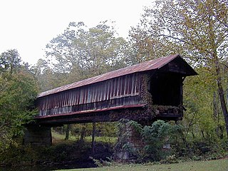
The Swann Covered Bridge, also called the Joy Covered Bridge or Swann-Joy Covered Bridge, is a county-owned, wood-and-metal combination style covered bridge that spans the Locust Fork of the Black Warrior River in Blount County, Alabama, United States. It is located on Swann Bridge Road off State Route 79, just west of the town of Cleveland, about 10 miles (16 km) northwest of Oneonta.

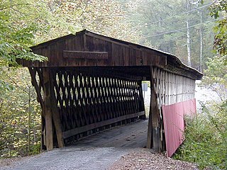
The Clarkson–Legg Covered Bridge, more simply known as Clarkson Covered Bridge, is a county-owned wooden covered bridge that spans Crooked Creek in Cullman County, Alabama, United States. It is located at Clarkson Covered Bridge Park on County Road 1043 off U.S. Route 278 near the community of Bethel, about 8 mi (13 km) west of Cullman.

The Horton Mill Covered Bridge is a state-owned wooden covered bridge that spans the Calvert Prong of the Little Warrior River in Blount County, Alabama, United States. It is located on a river crossing to Ebell Road and Covered Bridge Circle, off State Route 75 about 5 miles (8.0 km) north of the city of Oneonta.
The Easley Covered Bridge, also known as the Old Easley Covered Bridge or Rosa Covered Bridge, is a county-owned wood and metal combination style covered bridge that spans Dub Branch of the Calvert Prong of the Little Warrior River in Blount County, Alabama, United States. It is located on Easley Bridge Road off U.S. Route 231, just south of the town of Rosa, about 5 miles northwest of Oneonta. Coordinates are 33°58′16″N86°31′07″W.

The Salem-Shotwell Covered Bridge, also known as the Pea Ridge Covered Bridge, is a locally owned wooden covered bridge that spans Rocky Brook in Lee County, Alabama, United States. It is located halfway down Park Road at Opelika Municipal Park, which is off North 5th Street in the city of Opelika. Coordinates are 32°39′33.46″N85°22′52.94″W.
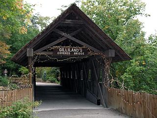
The Gilliland-Reese Covered Bridge, more simply known as Gilliland's Covered Bridge, is a locally owned wooden covered bridge that spans a small pond near Black Creek in Etowah County, Alabama, United States. It is located at Noccalula Falls Park off Noccalula Road in the city of Gadsden. Coordinates are 34°02′21.79″N86°01′26.93″W. Noccalula Falls Park is also home to the 90-foot (27 m) Noccalula Falls, part of Black Creek as it cascades down into a ravine from a ledge off Lookout Mountain. There are a couple of sources which state the bridge spans Clayton Fish Pond, but that is over a mile west of the park along a rural section of Hinds Road.

The Old Union Crossing Covered Bridge is a privately owned wood & metal combination style covered bridge that spans the West Fork of the Little River in DeKalb County, Alabama, United States. It is located on an access road between Shady Grove Dude Ranch and Cloudmont Ski & Golf Resort on Lookout Mountain, which is off County Road 614 near the town of Mentone. Coordinates are 34°32′3.51″N85°35′56.47″W.
The Oakachoy Covered Bridge, also known as the Thomas Covered Bridge, was a county-owned wooden covered bridge which spanned Oakachoy Creek in Coosa County, Alabama, United States. It was located in a remote area on the dirt portion of Newman Road off State Route 259 northeast of the community of Nixburg, about 6 miles southwest of Alexander City.
The Lidy Walker Covered Bridge, formerly known as the Big Branch Covered Bridge, was a privately owned wood-&-metal combination style covered bridge which spanned the outlet to Lidy's Lake in Cullman County, Alabama, United States. It was located in the Berlin community at a pasture near the lake off Cullman County Road 1616 near U.S. Route 278, 6 miles east of the city of Cullman.
The Tallahatchee Covered Bridge, also known as the Prickett Covered Bridge, was a privately owned wood and metal combination style covered bridge which spanned a pond near Nances Creek in Calhoun County, Alabama, United States. It was located just off State Route 9, about 2 miles south of the city of Piedmont. Approximate coordinates were 33°53′16.13″N85°37′33.70″W.
University Charter School (UCS) is a charter school in Lyon Hall, on the campus of the University of West Alabama in Livingston, Alabama.

Alamuchee Creek is a stream in the U.S. states of Alabama and Mississippi. It is a tributary to the Sucarnoochee River.

