
The West Godavari district is a coastal district in the Indian state of Andhra Pradesh with an administrative headquarters in Bhimavaram. As of the 2011 Census of India, the district has an area of 2,178 km2 (841 sq mi) and a population of 1,779,935. It is bounded by the Krishna district and Bay of Bengal to the south, East Godavari district to the east, and Eluru district, Kolleru Lake and Upputeru Drain to the northwest.

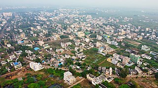
Eluru is a city and the district headquarters of Eluru district in the Indian state of Andhra Pradesh. It is one of the 14 municipal corporations in the state and the mandal headquarters of Eluru mandal in the Eluru revenue division. Situated on the banks of the Tammileru River, Eluru is strategically positioned in the southeastern part of Andhra Pradesh. It was historically known as Helapuri. As of 2011 Census of India, the city had a population of 214,414, reflecting its status as a major urban centre. The city's historical significance dates back to the second century CE, with evidence of its ancient roots found in various archaeological sites and historical records. Eluru was a prominent town under the rule of the Qutub Shahis, who governed the region in the 16th century. It came under the control of the Mughal Empire in the 17th century as the empire expanded its influence across South India. The town later became part of the Nawab of Hyderabad's dominions in the 18th century. During British India, Eluru was incorporated into the Madras Presidency and made capital for Northern Circars in the early 19th century. The British established administrative and infrastructural developments in the town, shaping its modern identity.

Dwaraka Tirumala is a census town in Eluru district of the Indian state of Andhra Pradesh. It is located in Dwaraka Tirumala mandal of Jangareddygudem revenue division. The Venkateswara Temple is a pilgrimage center for hindus, which is the abode of Lord Venkateswara. This is often referred by the locals as Chinna Tirupati, meaning mini Tirupati.
Eluru mandal is one of the 28 mandals in Eluru district of the Indian state of Andhra Pradesh. It is administered under Eluru revenue division and its headquarters are located at Eluru city. The mandal is bounded by Pedapadu mandal, Pedavegi mandal, Denduluru mandal, Bhimadole mandal and it also borders Krishna district.

Eluru revenue division is an administrative division in the Eluru district of the Indian state of Andhra Pradesh. It is one of the 3 revenue divisions in the district which consists of 13 mandals under its administration. Eluru city is the divisional headquarters.
Eluru Municipal Corporation is the civic body that governs the city of Eluru in the Indian state of Andhra Pradesh.Municipal Corporation mechanism in India was introduced during British Rule with formation of municipal corporation in Madras (Chennai) in 1688, later followed by municipal corporations in Bombay (Mumbai) and Calcutta (Kolkata) by 1762. Eluru Municipal Corporation is headed by Mayor of city and governed by Commissioner.
Tangellamudi is a census town in Eluru district of the Indian state of Andhra Pradesh. It is in Eluru mandal of Eluru revenue division. The town is a constituent of Eluru urban agglomeration. The nearest railway station is in Powerpet and is 1.5 km.

Gavaravaram is a census town in Eluru district of the Indian state of Andhra Pradesh. Gavaravaram is also known as Venkayapalam because of Gopina Venkana Garu (1914-1991) who once owned most areas of the village. It is located in Eluru mandal of Eluru revenue division. The town is a constituent of Eluru urban agglomeration.

Satrampadu is a census town in Eluru district of the Indian state of Andhra Pradesh. It is located in Eluru mandal of Eluru revenue division. The town is a constituent of Eluru urban agglomeration.

Sanivarapupeta is a census town in Eluru district of the Indian state of Andhra Pradesh. It is located in Eluru mandal of Eluru revenue division. The town is a constituent of Eluru urban agglomeration.
Pedavegi mandal is one of the 28 mandals in Eluru district of the Indian state of Andhra Pradesh. It is administered under Eluru revenue division and its headquarters are located at Pedavegi. The mandal is bounded by Eluru mandal, Denduluru mandal, Kamavarapukota mandal.
Bhimadole mandal is one of the 28 mandals in Eluru district of the Indian state of Andhra Pradesh. It is administered under Eluru revenue division and its headquarters are located at Bhimadole.
Eluru Rural is a partial out growth of Eluru in Eluru district of the Indian state of Andhra Pradesh. It is located in Eluru mandal of Eluru revenue division. It is also a constituent of Eluru urban agglomeration.
Sreeparru is a village in Eluru district in the state of Andhra Pradesh in India. It is 22 km from the city of Eluru, the headquarters of Eluru district.
Komadavole is an out growth of Eluru city in Eluru district of the Indian state of Andhra Pradesh. It is located in Eluru mandal of Eluru revenue division. It is also a constituent of Eluru Urban Agglomeration.
Chodimella is a village and census town in Eluru district of the Indian state of Andhra Pradesh. It is located in Eluru mandal of Eluru revenue division. The town is a constituent of Eluru urban agglomeration.
Jalipudi is a village in Eluru district of the Indian state of Andhra Pradesh. It is located in Eluru mandal of Eluru revenue division. The town is a constituent of Eluru urban agglomeration.
Madepalle is a village in Eluru district of the Indian state of Andhra Pradesh. It is located in Eluru mandal of Eluru revenue division. The town is a constituent of Eluru urban agglomeration.
Malkapuram is a village in Eluru district of the Indian state of Andhra Pradesh. It is located in Eluru mandal of Eluru revenue division. The town is a constituent of Eluru urban agglomeration.

Eluru district is a district in coastal Andhra Region in the Indian state of Andhra Pradesh. With Eluru as its administrative headquarters, it was proposed on 26 January 2022 to become one of the resultant twenty six districts in the state once a final notification is issued by the government of Andhra Pradesh. It is formed from Eluru revenue division and Jangareddygudem revenue division from West Godavari district and Nuzvid revenue division from Krishna district.

