
India is the most populous country in the world with one-sixth of the world's population. According to UN estimates, India overtook China in having the largest population in the world with a population of 1,425,775,850 at the end of April 2023.
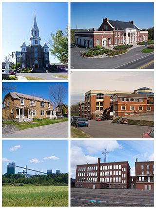
Alma is a town in Saguenay–Lac-Saint-Jean, in the Canadian province of Quebec.

An urban area, built-up area or urban agglomeration is a human settlement with a high population density and an infrastructure of built environment. This is the core of a metropolitan statistical area in the United States, if it contains a population of more than 50,000.
Astromeritis is a large village in the Morphou Department of the Nicosia District of Cyprus. It is located 30 km (18.64 mi) from the capital Nicosia. By the 2011 census it had a total population of 2,307.
Kamëz is a municipality in Tirana County, Albania. It was formed at the 2015 local government reform by the merger of the former municipalities Kamëz and Paskuqan, that became municipal units. The seat of the municipality is the town Kamëz. The total population is 104,190, in a total area of 37.20 km2. The population of the former municipality at the 2011 census was 66,841.

Joypur is a community development block that forms an administrative division in the Bishnupur subdivision of the Bankura district in the Indian state of West Bengal.
Allowal is a medium size village in Phillaur tehsil of Jalandhar District of Punjab State, India. It is located 5 km away from postal head office Phillaur, 14.8 km from Goraya, 48 km from Jalandhar and 111 km from state capital Chandigarh. The village is administrated by a sarpanch who is an elected representative of village as per Panchayati raj (India).

Dakauli is a village in Dalmau block of Rae Bareli district, Uttar Pradesh, India. It is located 5 km from Lalganj, the nearest large town. As of 2011, it has a population of 665 people, in 130 households. It has one primary school and no healthcare facilities and does not host a permanent market or weekly haat. It belongs to the nyaya panchayat of Aihar.

Bela Khara is a village in Rahi block of Rae Bareli district, Uttar Pradesh, India. It is located 15 km from Rae Bareli, the district headquarters. As of 2011, it has a total population of 5,928 people, in 1,071 households. It has one primary school and no medical facilities and it hosts both a weekly haat and a permanent market. It belongs to the nyaya panchayat of Bela Bhela.
Bela Tekai is a village in Rahi block of Rae Bareli district, Uttar Pradesh, India. It is located 14 km from Rae Bareli, the district headquarters. As of 2011, it has a total population of 5,928 people, in 1,071 households. It has 3 primary schools and no medical facilities and it does not host a weekly haat or a permanent market. It belongs to the nyaya panchayat of Bela Bhela.
Paraura is a village in Rahi block of Rae Bareli district, Uttar Pradesh, India. It is located 13 km from Rae Bareli, the district headquarters. As of 2011, it has a total population of 1,060 people, in 191 households. It has one primary school and no medical facilities and it does not host a weekly haat or a permanent market. It belongs to the nyaya panchayat of Bhaon.
Raghunathpur is a village in Rahi block of Rae Bareli district, Uttar Pradesh, India. It is located 11 km from Rae Bareli, the district headquarters. As of 2011, it has a total population of 1,217 people, in 207 households. It has one primary school and no medical facilities and it does not host a weekly haat or a permanent market. It belongs to the nyaya panchayat of Bhadokhar.
Bhakarwara is a village in Rahi block of Rae Bareli district, Uttar Pradesh, India. It is located 12 km from Rae Bareli, the district headquarters. As of 2011, it has a total population of 876 people, in 168 households. It has no schools and no medical facilities and it does not host a weekly haat or a permanent market. It belongs to the nyaya panchayat of Bhadokhar.
Bakwara is a village in Rahi block of Rae Bareli district, Uttar Pradesh, India. It is located 15 km from Rae Bareli, the district headquarters. As of 2011, it has a total population of 1,540 people, in 257 households. It has one primary school and no medical facilities and it hosts a weekly haat but not a permanent market. It belongs to the nyaya panchayat of Rustampur.
Chak Lodipur is a village in Rahi block of Rae Bareli district, Uttar Pradesh, India. It is located 8 km from Rae Bareli, the district headquarters. As of 2011, it has a total population of 449 people, in 89 households. It has one primary school and no medical facilities and it does not host a weekly haat or a permanent market. It belongs to the nyaya panchayat of Rustampur.
Paintemau is a village in Rahi block of Rae Bareli district, Uttar Pradesh, India. It is located 6 km from Rae Bareli, the district headquarters. As of 2011, it has a total population of 617 people, in 112 households. It has one primary school and no medical facilities and it does not host a weekly haat or a permanent market. It belongs to the nyaya panchayat of Rustampur.
Saidanpur is a village in Rahi block of Rae Bareli district, Uttar Pradesh, India. It is located 9 km from Rae Bareli, the district headquarters. As of 2011, it has a total population of 1,854 people, in 330 households. It has one primary school and no medical facilities and it hosts a permanent market but not a weekly haat. It belongs to the nyaya panchayat of Khagipur Sandwa.
Anti Naugawan is a village in Rahi block of Rae Bareli district, Uttar Pradesh, India. It is located 15 km from Rae Bareli, the district headquarters. As of 2011, it has a total population of 2,668 people, in 464 households. It has one primary school and no medical facilities and it does not host a permanent market or a weekly haat. It belongs to the nyaya panchayat of Lodhwari.