
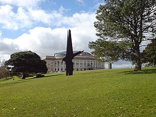
Aotea Square is a large paved public area in the CBD of Auckland, New Zealand. Officially opened in 1979 by Sir Dove-Myer Robinson next to Queen Street, it is used for open-air concerts and gatherings, markets, and political rallies. In November 2010, a major redevelopment of Aotea Square was completed. The square was redesigned to make it appropriate for use by crowds of up to 20,000 people.

Albany is one of the northernmost suburbs of the contiguous Auckland metropolitan area in New Zealand. It is located on the North Shore, 15 kilometres (9 mi) northwest of the Auckland city centre. Albany is found at the headlands of Lucas Creek, and was the location of a portage used by Tāmaki Māori, where waka could be taken between the Upper Waitematā Harbour and the Okura River/Hauraki Gulf. During the 1840s, early European settlers established the village of Lucas Creek, which became by the 1880s had become a major fruit growing centre in Auckland. The town voted to change the name from Lucas Creek to Albany in 1890.

Sylvia Park is a large business park and shopping centre in the Auckland suburb of Mount Wellington in New Zealand. Less commonly known, the area around the centre is also called Sylvia Park. The area is located adjacent to two major interchanges of the Auckland Southern Motorway – the South Eastern Highway and Mount Wellington Highway.
Carlaw Park was a multi-purpose stadium in Parnell, a central suburb of Auckland, New Zealand. It neighboured the Auckland Domain's Northern end. It was primarily used for rugby league and had a peak spectator capacity of around 28,000 in the 1930s, though this fell to around 17,000 by the time the ground was closed in 2002. It is now the site of several offices and the University of Auckland's largest student accommodation Carlaw Park Student Village.
The Auckland Domain, also known as Pukekawa / Auckland Domain, is a large park in Auckland, New Zealand. Consisting of 75 hectares of land, Auckland Domain is the oldest park in the city. Located in the central suburb of Grafton, the parkland is the remains of the explosion crater and most of the surrounding tuff ring of the Pukekawa volcano.

The Auckland Northern Motorway in the Auckland Region of New Zealand links Central Auckland and Warkworth in the former Rodney District via the Hibiscus Coast and North Shore. It is part of State Highway 1.

Westfield Albany is a shopping centre in the Auckland suburb of Albany, New Zealand, opposite the Albany Lakes Civic Park. It is majority owned (51%) by Scentre Group with the remainder owned by the Singapore Government's GIC. Until 2014 it was wholly owned by Scentre Group, which was formerly part of Westfield Group.

The Auckland waterfront is a city-side stretch of the southern Waitematā Harbour coastline in Auckland, New Zealand. Previously mostly dominated by Ports of Auckland uses, from the 2000s on it is becoming increasingly open to recreational public use, with a number of former wharves being converted to office, entertainment, and later also some residential uses.

Westhaven Marina in Auckland, New Zealand, is the largest yacht marina in the Southern Hemisphere. The marina has nearly two thousand berths and swing moorings, and tends to be continually booked. Auckland, known as 'City of Sails', is generally known for its maritime passions.

The Auckland Central Business District (CBD), or Auckland city centre, is the geographical and economic heart of the Auckland metropolitan area. It is the area in which Auckland was established in 1840, by William Hobson on land gifted by mana whenuahapū Ngāti Whātua Ōrākei. It is New Zealand's leading financial hub, and the centre of the country's economy; the GDP of the Auckland Region was NZD$139 billion in the year ending September 2023.

The Victoria Park Viaduct is a major motorway viaduct carrying the Auckland Northern Motorway over the Victoria Park area in the Auckland city centre, New Zealand. Construction began in 1959, and the bridge was opened on 5 April 1962. Due to the high traffic volumes passing through on their way to and from North Shore City, and because the viaduct is only four lanes wide in total, the bridge over the park is considered "one of the country's worst traffic bottlenecks", with around 200,000 vehicles a day.

Tank Farm is the name of a volcanic explosion crater on the North Shore of Auckland, New Zealand, near the approaches to the Auckland Harbour Bridge.

Meola Reef, or Te Tokaroa in Māori, is a lava flow forming a reef peninsula across part of Auckland's Waitemata Harbour, New Zealand. The reef extends for over 2 kilometres across the harbour, to within 500 metres of Kauri Point on the northern shore.

Auckland Council is the local government council for the Auckland Region in New Zealand. It is a territorial authority that has the responsibilities, duties and powers of a regional council and so is a unitary authority, according to the Local Government Act 2009, which established the council. The governing body consists of a mayor and 20 councillors, elected from 13 wards. There are also 149 members of 21 local boards who make decisions on matters local to their communities. It is the largest council in Oceania, with a $3 billion annual budget, $29 billion of ratepayer equity, and 9,870 full-time staff as of 30 June 2016. The council began operating on 1 November 2010, combining the functions of the previous regional council and the region's seven city and district councils into one "super council" or "super city".
Queens Wharf is a concrete wharf in Auckland, New Zealand, that continues off Queen Street. It opened in 1913, replacing the Queen Street Wharf, a succession of wooden wharves first built in 1852. Queens Wharf was owned and used by Ports of Auckland until 2010.
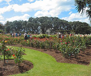
Dove-Myer Robinson Park, more commonly known as the Parnell Rose Garden, is a park in Parnell, Auckland, New Zealand. The park is named after Dove-Myer Robinson, the longest-serving mayor of Auckland, who served for 18 years. There are over 5,000 roses in the garden. Some of the plants in the garden have been bred by internationally celebrated rose breeders.

Blandford Park, in Auckland, New Zealand, was the home of association football in Auckland for much of the 20th century, and one of the country's main football grounds. Located in Grafton Gully, northeast of Grafton Bridge, roughly between the northern part of Whitaker Place and the Auckland Bowls Club in Grafton Mews, it was razed in the mid-1960s, and its site is now occupied by on- and off-ramps to the Auckland Central Motorway Junction.
The North Auckland and Northland (NAaN) grid upgrade project reinforced transmission into the Auckland Region and across the harbour to North Auckland and the Northland Region. It added new 220 kV transmission capacity to the National Grid by providing 37 km of underground cable between the Pakuranga, Penrose, and Albany substations.

Auckland District Health Board (ADHB) was a district health board that provided healthcare in the Auckland Region in New Zealand, mainly on the Auckland isthmus. This district health board existed between 2001 and 2022 and was governed by a part-elected, part-appointed board. In 2022, its functions and responsibilities were subsumed by Te Whatu Ora and Te Aka Whai Ora.

Herald Island is an island of approximately 100 acres (40 ha) in the Upper Waitematā Harbour in Auckland, New Zealand.

