
The Gambia, officially the Republic of The Gambia, is a country in West Africa. It is the smallest country within mainland Africa and is surrounded by Senegal, except for its western coast on the Atlantic Ocean. The Gambia is situated on both sides of the lower reaches of the Gambia River, the nation's namesake, which flows through the centre of the Gambia and empties into the Atlantic Ocean, thus the long shape of the country. It has an area of 10,689 square kilometres (4,127 sq mi) with a population of 1,857,181 as of the April 2013 census. Banjul is the Gambian capital and the country's largest metropolitan area. The largest cities are Serekunda and Brikama.
Banjul, officially the City of Banjul, is the capital and fourth largest city of The Gambia. It is the centre of the eponymous administrative division which is home to an estimated 400,000 residents, making it The Gambia's largest and most densely populated metropolitan area. Banjul is on St Mary's Island, where the Gambia River enters the Atlantic Ocean. The population of the city proper is 31,301, with the Greater Banjul Area, which includes the City of Banjul and the Kanifing Municipal Council, at a population of 413,397. The island is connected to the mainland to the west and the rest of Greater Banjul Area via bridges. There are also ferries linking Banjul to the mainland at the other side of the river.

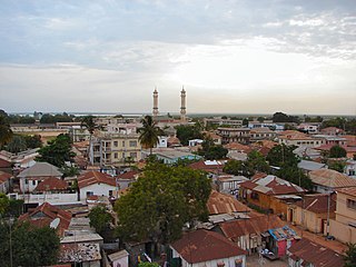
Serekunda is the largest urban centre in The Gambia. It is situated close to the Atlantic coast, 13 km (8 mi) south-west of the capital, Banjul, and is formed of nine villages which have grown together into a larger urban area.

Bakau is a town on the Atlantic coast of Gambia, west of Gambia's capital city of Banjul. It is known for its botanical gardens, its crocodile pool Bakau Kachikally and for the beaches at Cape Point. Bakau is the first major suburb outside Banjul and the most developed town in the Gambia. Close to Bakau and Banjul is Gambia's largest city, Serekunda.
Kanifing is a town in the Gambia, and lies immediately west of the capital city of Banjul.
Banjul International Airport, also known as Yundum International, is the international airport of Banjul, capital of the Gambia, built during World War II.
Kerewan is a town in the Gambia. Located beside the Miniminiyang Bolong, about 60 km from the capital Banjul. It is the seat of the Kerewan Local Government Area, located on the north bank of the lower river Gambia.
The Gambia is subdivided into 43 districts. They are listed below by Local Government Area, each with its population at the 15 April 2013 census.
The Daily Observer is a newspaper published in Bakau in Banjul, the Gambia.

Gambian–American relations are bilateral relations between the Republic of The Gambia and the United States of America.
The Roman Catholic Diocese of Banjul is a diocese located in the city of Banjul in the Gambia.

Dog Island is a small island, situated on the Gambia River in the Republic of the Gambia about 13 kilometres from the mouth of the river to the Atlantic Ocean. The area of the island is less than 3.5 hectares. During low tide the island is connected to the mainland, but during high tide it is separated by about 150 metres from the headland of Dog Island Point on the north bank of the river. The island is named after the sound made by the resident baboons, which from a distance sounds like dogs barking.

Edward Francis Small Teaching Hospital (EFSTH) is a tertiary referral hospital in Banjul, the capital city of The Gambia. It is the largest hospital in the country, originally founded by British colonialists in 1853. Until 2013, it was known as the Royal Victoria Teaching Hospital (RVTH).
Banjul American International School (BAIS) is an American international school in the Banjul area of the Gambia. Formerly titled the Banjul American Embassy School (BAES), the school serves preschool through high school.
École Française de Banjul is a French international school in Bakau, The Gambia, in the Banjul metropolitan area. It serves levels preschool through première; classes use the National Centre for Distance Education (CNED) beginning in sixième. It was established in 1984.

The Our Lady of the Assumption Cathedral or simply Banjul Cathedral, is a Roman Catholic church located in Banjul the capital of the African country of Gambia.

The Bathurst Decauville Tramway was a 1.9 km (1.2 mi) long 600 mm gauge railway in Bathurst, British Gambia. It was hand-operated. It opened in 1907 and closed in the mid-1950s.

The Pipeline Mosque is the main mosque of Serekunda, The Gambia.


