Related Research Articles

Oxfordshire is a landlocked county in South East England. The ceremonial county borders Warwickshire to the north-west, Northamptonshire to the north-east, Buckinghamshire to the east, Berkshire to the south, Wiltshire to the south-west and Gloucestershire to the west.

The Kennet and Avon Canal is a waterway in southern England with an overall length of 87 miles (140 km), made up of two lengths of navigable river linked by a canal. The name is used to refer to the entire length of the navigation rather than solely to the central canal section. From Bristol to Bath the waterway follows the natural course of the River Avon before the canal links it to the River Kennet at Newbury, and from there to Reading on the River Thames. In all, the waterway incorporates 105 locks.

The River Loddon is a tributary of the River Thames in southern England. It rises at Basingstoke in Hampshire and flows northwards for 28 miles (45 km) to meet the Thames at Wargrave in Berkshire. Together, the Loddon and its tributaries drain an area of 400 square miles (1,036 km2).

Aldermaston is a mostly rural, dispersed settlement, civil parish and electoral ward in Berkshire, England. In the United Kingdom Census 2011, the parish had a population of 1015. The village is in the mid-Kennet alluvial plain and bounds to Hampshire in the south. It is roughly equidistant from Newbury, Basingstoke and Reading, centred 46 miles (74 km) west-by-south-west of London.

Aldermaston Court is a country house and private park built in the Victorian era for Daniel Higford Davall Burr with incorporations from a Stuart house. It is south-east of the village nucleus of Aldermaston in the English county of Berkshire. The predecessor manor house became a mansion from the wealth of its land and from assistance to Charles I during the English Civil War under ownership of the Forster baronets of Aldermaston after which the estate has alternated between the names Aldermaston Park and Aldermaston Manor.

Ufton Nervet is a village and civil parish in West Berkshire, England centred 6 miles (10 km) west southwest of the large town of Reading and 7 miles east of Thatcham. Ufton Nervet has an elected civil parish council.

Theale is a large village and civil parish in West Berkshire, England, 5 miles (8 km) southwest of Reading and 10 miles (16 km) east of Thatcham.
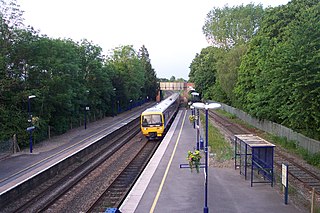
Aldermaston railway station serves the village of Aldermaston in Berkshire, England. The station is at nearby Aldermaston Wharf and about 2 miles (3 km) north of Aldermaston village. It is 44 miles 63 chains (72.08 km) measured from London Paddington.

County Lock is a lock on the River Kennet in Reading town centre in the English county of Berkshire. It is now administered by the Canal & River Trust as part of the Kennet and Avon Canal. Downstream from the lock is Brewery Gut, a particularly fast flowing, narrow and dangerous stretch of the river.

Aldermaston Wharf is a small multi-parish settlement centred 1.5 miles (2.4 km) north-northwest of Aldermaston in West Berkshire, England. The Kennet and Avon Canal passes through the settlement with Aldermaston Lock near the centre while the Great Western Railway passes at the northern side where Aldermaston railway station is also located. The A340 road from Basingstoke passes through the village crossing the canal over a single file lift bridge and joins the A4 road which runs just north of the village.

Padworth is a lightly populated locality and civil parish in the English county of Berkshire, the nearest town to which is Tadley. Padworth is in the unitary authority of West Berkshire and its main settlement is at Aldermaston Wharf or Lower Padworth where it has Aldermaston railway station. It has its southern boundary with Mortimer West End, Hampshire. The south of the parish is wooded towards its edges and the north of the parish is agricultural with a hotel beside the Kennet and Avon Canal. In the centre of the parish is a school, Padworth College, which is a Georgian and later incarnation of its manor house.
Burghfield is a village and large civil parish in West Berkshire, England, with a boundary with Reading. Burghfield can trace its history back to before the Domesday book, and was once home to three manors: Burghfield Regis, Burghfield Abbas and Sheffield. Since the 1980s the population of Burghfield has nearly doubled with the construction of many new housing estates, dependent for its employment on, for instance, Reading, Newbury and Basingstoke and M4 corridor which bisects the edge of the area.
Baughurst is a village and civil parish in Hampshire, England. It is located west of the town of Tadley, 6 miles (9.7 km) north of Basingstoke. In the 2001 census it had a population of 2,473.

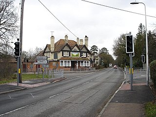
The A340 is a major road in the south of England, portions of which are known as the Aldermaston Road, Tadley Hill, Basingstoke Road and Tidmarsh Road.

Drayton is a village and civil parish about 2 miles (3 km) south of Abingdon, Oxfordshire. It was part of Berkshire until the 1974 boundary changes transferred it to Oxfordshire. The parish includes the hamlet of Sutton Wick. The 2011 Census recorded the parish population as 2,353.
H & G Simonds Ltd was a brewery founded in Reading, Berkshire, England in 1785 by William Blackall Simonds. The company amalgamated with Courage & Barclay in 1960 and dropped the Simonds name after ten years. Eventually the firm became part of Scottish & Newcastle who sold the brands to Wells & Young's Brewery in 2007 and closed the Reading brewery three years later.
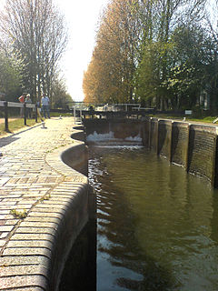
Aldermaston Lock is a lock on the Kennet and Avon Canal, at Aldermaston Wharf in the English county of Berkshire. It stands at the junction of the civil parishes of Padworth, Beenham and Aldermaston.

Padworth Lock is a lock on the Kennet and Avon Canal, at Aldermaston Wharf in the civil parish of Padworth in the English county of Berkshire.

The Bladebone Inn is a public house at Chapel Row in the civil parish of Bucklebury in the English county of Berkshire.

The Church of St Mary the Virgin, Aldermaston is the Church of England parish church of Aldermaston in Berkshire. The church, which is dedicated to St Mary, dates from the mid-12th century and has examples of Norman and Jacobean architecture. The building has had a number of extensions, particularly in the 13th, 14th, 15th and 17th centuries.
References
- 1 2 "Records of Berkshire breweries subsequently owned by Whitbread & Co. plc". Berkshire Record Office. Archived from the original on 19 January 2010. Retrieved 5 March 2010.
- ↑ "Amazing Aldermaston: Bridge House, Mill Lane". Heritage Open Days. English Heritage. Archived from the original on 19 April 2013. Retrieved 18 May 2010.
- 1 2 Ingram, Christine; Ingram, Tony; Ridley, Pamela, eds. (1976). The History of Some Berkshire Inns and Their Signs. Reading: The Berkshire Federation of Women's Institute. pp. 48–49.
- ↑ Hill, Harold (1971). Images of Reading and Surrounding Villages. Reading Evening Post. ISBN 1-85983-024-2.
- ↑ Richmond, Lesley; Turton, Alison, eds. (1990). The Brewing Industry: A Guide to Historical Records. Manchester University Press. p. 315. ISBN 0-7190-3032-3.
- ↑ "1945 to 1969: Wethereds". The History of Strong's of Romsey. 9 September 2009. Archived from the original on 27 October 2011. Retrieved 5 March 2010.
- ↑ "Aldermaston Parish Plan 2005" (PDF). Aldermaston Parish Council. 27 January 2006. Archived from the original (PDF) on 4 March 2011. Retrieved 5 March 2010.
Coordinates: 51°24′00″N1°08′14″W / 51.3999°N 1.1373°W
| This article about a company of the UK is a stub. You can help Wikipedia by expanding it. |