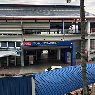
Taman Paramount LRT station is an LRT station in Petaling Jaya that is served by rapidKL's Kelana Jaya Line. This station is located in Taman Paramount, Petaling Jaya, Selangor, Malaysia.

Pińczata is a village in the administrative district of Gmina Włocławek, within Włocławek County, Kuyavian-Pomeranian Voivodeship, in north-central Poland. It lies approximately 6 kilometres (4 mi) south of Włocławek and 58 km (36 mi) south-east of Toruń.
Łosośna Wielka is a village in the administrative district of Gmina Kuźnica, within Sokółka County, Podlaskie Voivodeship, in north-eastern Poland, close to the border with Belarus.
Majków Średni is a village in the administrative district of Gmina Grabica, within Piotrków County, Łódź Voivodeship, in central Poland. It lies approximately 9 kilometres (6 mi) south-east of Grabica, 7 km (4 mi) north-west of Piotrków Trybunalski, and 41 km (25 mi) south of the regional capital Łódź.
Olszynki is a village in the administrative district of Gmina Kobiele Wielkie, within Radomsko County, Łódź Voivodeship, in central Poland. It lies approximately 4 kilometres (2 mi) south of Kobiele Wielkie, 14 km (9 mi) south-east of Radomsko, and 87 km (54 mi) south of the regional capital Łódź.

Zalesie is a village in the administrative district of Gmina Kamienica, within Limanowa County, Lesser Poland Voivodeship, in southern Poland. It lies approximately 6 kilometres (4 mi) north of Kamienica, 11 km (7 mi) south-west of Limanowa, and 57 km (35 mi) south-east of the regional capital Kraków.
Brzezna is a village in the administrative district of Gmina Podegrodzie, within Nowy Sącz County, Lesser Poland Voivodeship, in southern Poland. It lies approximately 7 kilometres (4 mi) west of Nowy Sącz and 71 km (44 mi) south-east of the regional capital Kraków.
Stawiany is a village in the administrative district of Gmina Kije, within Pińczów County, Świętokrzyskie Voivodeship, in south-central Poland. It lies approximately 3 kilometres (2 mi) south-east of Kije, 9 km (6 mi) north-east of Pińczów, and 33 km (21 mi) south of the regional capital Kielce.
Wymysłów is a village in the administrative district of Gmina Kije, within Pińczów County, Świętokrzyskie Voivodeship, in south-central Poland. It lies approximately 3 kilometres (2 mi) north-east of Kije, 12 km (7 mi) north-east of Pińczów, and 29 km (18 mi) south of the regional capital Kielce.
Dąbrówka is a village in the administrative district of Gmina Białobrzegi, within Białobrzegi County, Masovian Voivodeship, in east-central Poland. It lies approximately 6 kilometres (4 mi) south of Białobrzegi and 69 km (43 mi) south of Warsaw.
Karolinowo is a village in the administrative district of Gmina Nowe Miasto, within Płońsk County, Masovian Voivodeship, in east-central Poland.
Mariówka is a village in the administrative district of Gmina Przysucha, within Przysucha County, Masovian Voivodeship, in east-central Poland.
Dębe Duże is a village in the administrative district of Gmina Jadów, within Wołomin County, Masovian Voivodeship, in east-central Poland.
Lutkówka-Kolonia is a village in the administrative district of Gmina Mszczonów, within Żyrardów County, Masovian Voivodeship, in east-central Poland. It lies approximately 8 kilometres (5 mi) south-east of Mszczonów, 19 km (12 mi) south-east of Żyrardów, and 43 km (27 mi) south-west of Warsaw.
Żółcz is a village in the administrative district of Gmina Niechanowo, within Gniezno County, Greater Poland Voivodeship, in west-central Poland.
Dziewiątka is a village in the administrative district of Gmina Człuchów, within Człuchów County, Pomeranian Voivodeship, in northern Poland. It lies approximately 7 kilometres (4 mi) south-west of Człuchów and 122 km (76 mi) south-west of the regional capital Gdańsk.
Tęguty is a settlement in the administrative district of Gmina Barczewo, within Olsztyn County, Warmian-Masurian Voivodeship, in northern Poland.
Naćmierz is a settlement in the administrative district of Gmina Resko, within Łobez County, West Pomeranian Voivodeship, in north-western Poland. It lies approximately 16 kilometres (10 mi) south-east of Resko, 11 km (7 mi) north of Łobez, and 76 km (47 mi) north-east of the regional capital Szczecin.
Wicko Morskie is a village in the administrative district of Gmina Postomino, within Sławno County, West Pomeranian Voivodeship, in north-western Poland. It lies approximately 10 kilometres (6 mi) north-west of Postomino, 21 km (13 mi) north of Sławno, and 183 km (114 mi) north-east of the regional capital Szczecin.
Szilvágy is a village in Zala County, Hungary.


