
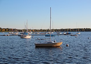
Scott County is a county in the U.S. state of Minnesota. As of the 2020 census, the population was 150,928. Its county seat is Shakopee. Shakopee is also the largest city in Scott County, the twenty-third-largest city in Minnesota, and the sixteenth-largest Twin Cities suburb. The county was organized in 1853 and named in honor of General Winfield Scott. Scott County is part of the Minneapolis-St. Paul-Bloomington, MN-WI Metropolitan Statistical Area. It is a member of the Metropolitan Council, and shares many of the council's concerns about responsible growth management, advocating for progressive development concepts such as clustering, open-space design, and the preservation of open space and rural/agricultural land.

Rock County is a county at the southwestern corner of the U.S. state of Minnesota. As of the 2020 census, the population was 9,704. Its county seat is Luverne.

Dakota County is the third-most populous county in the U.S. state of Minnesota, located in the east central portion of the state. As of the 2020 census, the population was 439,882. The population of Dakota County was estimated to be 443,341 in 2022. The county seat is Hastings. Dakota County is named for the Dakota Sioux tribal bands who inhabited the area. The name is recorded as "Dahkotah" in the United States Census records until 1851. Dakota County is included in the Minneapolis–St. Paul–Bloomington, MN–WI Metropolitan Statistical Area, the sixteenth largest metropolitan area in the United States with about 3.64 million residents. The largest city in Dakota County is the city of Lakeville, the eleventh-largest city in Minnesota and sixth-largest Twin Cities suburb. The county is bordered by the Minnesota and Mississippi Rivers on the north, and the state of Wisconsin on the east.

Minneapolis–Saint Paul is a metropolitan area in the Upper Midwestern United States centered around the confluence of the Mississippi, Minnesota and St. Croix rivers in the U.S. state of Minnesota. It is commonly known as the Twin Cities after the area's two largest cities, Minneapolis and Saint Paul. Minnesotans often refer to the two together simply as "the cities". It is Minnesota's economic, cultural, and political center.

Fridley is a city in Anoka County, Minnesota, United States. Its population was 29,590 at the 2020 census. Fridley was incorporated in 1949 as a village, and became a city in 1957. It is part of the Minneapolis–Saint Paul metropolitan area as a "first-ring" or "inner-ring" suburb its northern part. Fridley borders Minneapolis to the southwest. Neighboring first-ring suburbs are Columbia Heights to the south and Brooklyn Center to the west, across the Mississippi River.

Hastings is a city mostly in Dakota County, Minnesota, of which it is the county seat, with a portion in Washington County, Minnesota, United States. It is near the confluence of the Mississippi, Vermillion, and St. Croix Rivers. The population was 22,154 at the 2020 census. It is named for the first elected governor of Minnesota, Henry Hastings Sibley.
Bde Maka Ska is the largest lake in Minneapolis, Minnesota, United States, and part of the city's Chain of Lakes. Surrounded by city park land and circled by bike and walking trails, it is popular for many outdoor activities. The lake has an area of 401 acres (1.62 km2) and a maximum depth of 87 feet (27 m).

The Little Minnesota River is a 71.4-mile-long (114.9 km) headwaters tributary of the Minnesota River in northeastern South Dakota and west-central Minnesota in the United States. Via the Minnesota River, it is part of the Mississippi River watershed.
The Zumbro River is a tributary of the Mississippi River in the Driftless Area of southeastern Minnesota in the United States. It is 64.6 miles (104.0 km) long from the confluence of its principal tributaries and drains a watershed of 1,428 square miles (3,700 km2). The river's name in English is a change from its French name Rivière des Embarras due to its mouth near Pine Island in the Mississippi River; the pronunciation changed from [dez‿ɑ̃.ba.ʁɑ] to. The Dakota name for this river is Wapka Wazi Oju, having reference to the grove of great white pines at Pine Island.

The U.S. State of Minnesota is the northernmost state outside Alaska; its isolated Northwest Angle in Lake of the Woods is the only part of the 48 contiguous states lying north of the 49th parallel north. Minnesota is in the U.S. region known as the Upper Midwest in interior North America. The state shares a Lake Superior water border with Michigan and Wisconsin on the northeast; the remainder of the eastern border is with Wisconsin. Iowa is to the south, South Dakota and North Dakota are to the west, and the Canadian provinces of Manitoba and Ontario are to the north. With 87,014 square miles (225,370 km2), or approximately 2.26% of the United States, Minnesota is the 12th largest state.

The Sawtooth Mountains are a range of hills or small mountains on the North Shore of Lake Superior in the U.S. state of Minnesota, extending about 30 miles (48 km) from Carlton Peak near Tofte on the west, to Grand Marais on the east.
Ball Club is an unincorporated community and census-designated place (CDP) in Itasca County, Minnesota, United States; located within the Leech Lake Indian Reservation. As of the 2010 census, its population was 342. Ball Club is located between Zemple and Bena.
Delft is an unincorporated community located in Cottonwood County, Minnesota, United States in Carson Township.

Grindstone Lake is a large freshwater lake located in Dell Grove Township, Pine County, in east-central Minnesota approximately 6.5 miles (10.5 km) west of Sandstone, Minnesota. The lake is roughly oval shaped being approximately 2 miles (3.2 km) in length north to south and 0.5 miles (0.80 km) east to west, and a maximum depth of 153 feet (47 m). The lake has several small streams that drain the area wetlands and is considered the headwater for the Grindstone River. The lake's name is a translation from the Ojibwe zhiigwanaabikokaa-zaaga'igan. Sandstone taken from near the lake was used to make sharpening stones. The lake, North Fork Grindstone River and the lower course of the Grindstone River are depicted on the 1757 Mitchell Map.
Cedar Avenue is a roadway that runs from Minneapolis to Northfield in the U.S. state of Minnesota. The roadway is known as Minnesota State Highway 77 in the busiest portion of the route, from Minneapolis to Apple Valley. The portions north and south of this are county roads, Hennepin County 152 and Dakota County 23, respectively. Its northern terminus in Minneapolis is at Washington Avenue in Cedar-Riverside, though its alignment is briefly interrupted by an interchange at Hiawatha Avenue to the south.
Fox Lake is an unincorporated community in Martin County, in the U.S. state of Minnesota.
Lake Benton is a lake in Lincoln County, Minnesota, in the United States.

