Related Research Articles

The Au Sable River is a 138-mile-long (222 km) river in the Lower Peninsula of the U.S. state of Michigan. Rising in the Northern Lower Peninsula, the river flows in a generally southeasterly direction to its mouth at Lake Huron at the communities of Au Sable and Oscoda. It is considered one of the best brown trout fisheries east of the Rockies and has been designated a blue ribbon trout stream by the Michigan Department of Natural Resources. A map from 1795 located in the United States Gazetteer calls it the Beauais River. In French, the river is called the Rivière au sable, literally "Sand River".

Little Creek is a town in Kent County, Delaware, United States. It is part of the Dover metropolitan statistical area. The population was 195 in 2020.
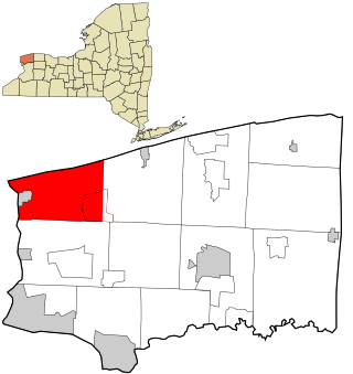
Porter is a town in Niagara County, New York, United States. The population was 6,771 at the 2010 census. The town was named after Judge Augustus Porter.
Haldimand County is a rural city-status single-tier municipality on the Niagara Peninsula in Southern Ontario, Canada, on the north shore of Lake Erie, and on the Grand River. Despite its name, it is no longer a county by definition, as all municipal services are handled by a single level of government. Municipal offices are located in Cayuga.

The Saugeen River is located in southern Ontario, Canada. The river begins in the Osprey Wetland Conservation Lands and flows generally north-west about 160 kilometres (99 mi) before exiting into Lake Huron. The river is navigable for some distance, and was once an important barge route. Today the river is best known for its fishing and as a canoe route.

The Sauble River is a river in Bruce County and Grey County in southwestern Ontario, Canada that flows from its headwaters in the township of Chatsworth to Lake Huron north of the community of Sauble Beach.
The Sydenham River is a river in Grey County in southern Ontario. The river flows north from a source near Williamsford, drops over the Niagara Escarpment at Inglis Falls and empties into Owen Sound harbour on Georgian Bay. It was named after Lord Sydenham, governor of Canada from 1839 to 1841. The river was formed from pre-glacial river along the Niagara Escarpment.

Simcoe—Grey is a federal electoral district in Ontario, Canada, that has been represented in the House of Commons of Canada since 1997.
The Speed River is a river that flows through Wellington County and the Region of Waterloo in southwestern Ontario, Canada. It flows south from its source near Orton, through Guelph, where it is joined by the Eramosa River, then through the towns of Hespeler and Preston, finally uniting with the Grand River in north-west Cambridge.

Southgate is a township in southwestern Ontario, Canada, in the southeast corner of Grey County. Southgate was formed on January 1, 2000, when the Village of Dundalk, the Township of Proton and the Township of Egremont were amalgamated. The headwaters of the South Saugeen, Beatty Saugeen and Grand Rivers are located in Southgate.

Hanover is a town in the Canadian province of Ontario with a population of about 7,967 residents. It is located in southwestern Grey County, bordering on Bruce County, west of Durham and east of Walkerton on Grey/Bruce Road 4. Hanover has a town hall, police department and the Hanover and District Hospital.

The Missisquoi River is a transboundary river of the east shore of Lake Champlain, approximately 80 miles (130 km) long, in northern Vermont in the United States and southern Quebec in Canada.
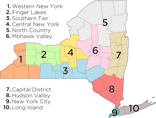
The North Country of Upstate New York is the northernmost region of the U.S. state of New York. It is bordered by Lake Champlain to the east and further east to the adjacent state of Vermont and the New England region; the Adirondack Mountains / Adirondack Park and the Upper Capital District with the state capital of Albany to the south; the Mohawk Valley region of New York to the southwest; the Canadian-American international border to the north; and Lake Ontario, and the Saint Lawrence River / Saint Lawrence Seaway, and beyond the waters again to Ontario / Canada to the west. A mostly rural forested area, the North Country includes seven counties of the 62 in New York state. Fort Drum, a United States Army base, is also located in the North Country region in Jefferson County, near Watertown, as is the adjacent Adirondack Park of 6.1 million acres, established 1892 as the oldest state park in the nation, and preserved / operated by the Adirondack Park Agency and the New York State Department of Environmental Conservation. As of 2024, the population of the region was 420,311.
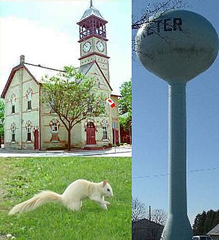
Exeter is a community in the municipality of South Huron, in the southern portion of Huron County, Ontario, Canada, located approximately 40 kilometres north of London. The community proclaims itself the "Home of the White Squirrel", owing to the presence of the unusually-coloured mammals. Exeter's mascot, "Willis The White Wonder", can be seen at many community events throughout the year, including Canada Day celebrations, the Exeter Rodeo, and the Santa Claus Parade.

Sandy Island Beach State Park is a New York State park on the eastern shore of Lake Ontario. Its highlight is a 1,500-foot (460 m) natural sandy beach. The park is near the southern end of a notable 17-mile (27 km) length of sandy shoreline, coastal dunes, and wetlands ; a 1959 study noted that "The eastern end of Lake Ontario contains not only the finest beaches on the entire lake but also the finest wildlife habitat."
Wychwood Park is a neighbourhood enclave and private community in Toronto, Ontario, Canada. It is located west of Bathurst Street on the north side of Davenport Road, within the larger area of Bracondale Hill. It is considered part of the overall Wychwood official neighbourhood as designated by the City of Toronto.

One of three waterfalls that surround the city of Owen Sound, Ontario, Canada, Inglis Falls is the largest and most impressive. It is also the most visited.

Wareham is a community in Grey County, Ontario. It is about 80 km northwest of Brampton, Ontario and about 60 km west of Barrie, Ontario. It is south of The Blue Mountains, Ontario and of the Grey Highlands.
Simcoe—Grey is a provincial electoral district in Ontario, Canada, that has been represented in the Legislative Assembly of Ontario since 1999.
The Warsaw Caves are a group of caverns, a geological feature located in the Warsaw Caves Conservation Area near the village of Warsaw, Ontario, Canada. The caves have long passages and mostly small open areas which are accessible to spelunkers.
References
- ↑ "Allan Park Conservation Area". 2011. Retrieved 2011-11-08.