The Piave is a river in northern Italy. It begins in the Alps and flows southeast for 220 kilometres (140 mi) into the Adriatic Sea near the city of Venice. One of its tributaries is the Boite.
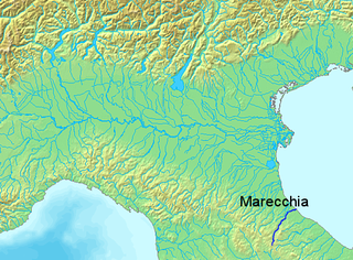
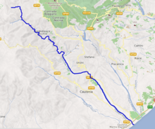
The Marecchia is a river in eastern Italy. In ancient times it was known as the Ariminus which was from the Greek Aríminos. The source of the river is near Monte dei Frati which is east of Pieve Santo Stefano and southwest of Badia Tedalda in the Province of Arezzo in Tuscany. It flows northeast into the Province of Pesaro and Urbino in the Marche and is the only river that runs through Montefeltro. While flowing through Montefeltro, the river flows through the exclave Santa Sofia Marecchia, which belongs to Badia Tedalda. The river then flows past Sant'Agata Feltria and Novafeltria before crossing into the Province of Rimini in Emilia–Romagna. At Torello, part of the commune of San Leo, it flows 1 km west of the Sammarinese territory Acquaviva and the San Marino River flows into it, but the Marecchia does not touch the San Marino border. Finally, the river flows past Verucchio and Santarcangelo di Romagna before flowing into the Adriatic Sea near Rimini.

The Ofanto, known in ancient times as Aufidus or Canna, is a 134 or 170 km river in southern Italy that flows through the regions of Campania, Basilicata, and Apulia, into the Gulf of Manfredonia near Barletta.

Stilo is a town and comune in the province of Reggio Calabria, in the Calabria region of southern Italy. It is 151 kilometres (94 mi) from Reggio.
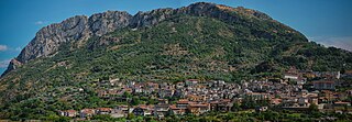
Bivongi is a comune (municipality) in the Province of Reggio Calabria in the Italian region Calabria, located about 50 kilometres (31 mi) southwest of Catanzaro and about 80 kilometres (50 mi) northeast of Reggio Calabria in the Stilaro Valley, at the feet of the Monte Consolino.

Placanica is a comune in the Province of Reggio Calabria in the Italian region Calabria, located about 60 kilometres (37 mi) south of Catanzaro and about 80 kilometres (50 mi) northeast of Reggio Calabria. Placanica borders the following communes: Caulonia, Pazzano, Stignano.

The Tronto is a 115-kilometre (71 mi) long Italian river that arises at Monti della Laga and ends in the Adriatic Sea at Porto d'Ascoli, San Benedetto del Tronto. It traverses the Lazio, Marche, and Abruzzo regions of Italy.
The Savuto is a river and valley in Calabria, Southern Italy, that lies at the intersection of the provinces of Cosenza and Catanzaro. It is also the name of a DOC wine produced in the region.

The Stilaro is an Italian river, which runs through Bivongi, Pazzano and Stilo in the Province of Reggio Calabria, Calabria and, along with the river, gives its name to the Vallata dello Stilaro Allaro, the valley through which it flows. It is 59.17 km long.

The Foglia is the northernmost river of the Marche region of Italy. In ancient times it was known as Pisaurus, as it debouched into the Adriatic Sea at Pisaurum. It was also known as the Isaurus. The source of the river is west of Sestino in the province of Arezzo in the Umbrian-Marchean Apennines mountains. It flows east through an extension of the province of Pesaro e Urbino and then back into Arezzo before forming the border between Arezzo and Pesaro e Urbino. The river then flows into the province of Pesaro e Urbino past Piandimeleto and curves northeast and flows past Sassocorvaro before curving east again. The river meanders south of Montecalvo in Foglia before curving northeast and flowing near Colbordolo, Saludecio, Sant'Angelo in Lizzola, Montecchio, Montelabbate and Tavullia before entering the Adriatic Sea near Pesaro.

The Aso is a 63-kilometre (39 mi) river in the Marche region of Italy. For most of its course the river marks the boundary between the provinces of Ascoli Piceno and Fermo

The Vomano is a 76 km river, which is in the Abruzzo region of Italy. Its source is near Monte San Franco in Gran Sasso d'Italia and Lago di Campotosto in the province of L'Aquila. The river crosses the border into the province of Teramo and flows northeast near Montorio al Vomano and Basciano. The Fucino flows into the Vomano south of Crognaleto and the Mavone flows into the Vomano near Basciano. It enters the Adriatic Sea near Roseto degli Abruzzi.

New Princeton is an unincorporated community in Harney County, in the U.S. state of Oregon. It is along Oregon Route 78 between Burns and Burns Junction at an elevation of 4,111 feet (1,253 m) above sea level. The South Fork Malheur River begins near Round Mountain, southeast of New Princeton.
The Maine River is a short river in Washington County, Maine. From the outlet of Pocomoonshine Lake in Princeton, it runs 5.5 miles (8.9 km) southwest to Crawford Lake in Plantation No. 21. The outlet of Crawford Lake is the East Machias River, flowing to Machias Bay.

The Musone is a river in the Marche region of Italy. The source of the river is east of Matelica and south of Monte San Vicino in the province of Macerata. The river flows northeast near Apiro, Cingoli and Staffolo before crossing into the province of Ancona near Filottrano. The river then flows southeast and is joined by a tributary south of Osimo before curving northeast near Loreto. Finally, the river empties into the Adriatic Sea north of Porto Recanati and south of Numana.
The Veimauri is a river of Papua New Guinea. It flows into Galley Reach of Redscar Bay to the north-west of Port Moresby. To the east of the mouth there are rubber and coconut plantations on the banks and the Veimauri River Bridge. The river area is protected under the Veimauri River Forest Reserve, which has a significant population of parrots.
Paris is an unincorporated community in Lane County, in the U.S. state of Oregon. It is a rural locale in the Central Oregon Coast Range north of the Siuslaw River and south of the Alsea River along one of its tributaries, Five Rivers. Paris is located at 44°15′09″N123°46′14″W.

Lake Circle was a glacial lake that formed during the late Pleistocene epoch along the Redwater River in eastern Montana. After the Laurentide Ice Sheet retreated, glacial ice melt accumulated in the basin surrounded by the ridges of the preglacial valley and the retreating glacier. Southwest of Nickwall are the remnants of a broad abandoned valley with long side slopes. The valley runs north from Redwater Creek to the Missouri River. The bottom is poorly drained and about 1 mile (1.6 km) in width. It lies 2,015 to 2,020 feet above the sea level and 40 to 50 feet above the Missouri River bottomland. The upland slopes are extensive, clear and flat. The valleys surrounding it are dissected with V-shaped coulees. The difference between the Redwater valley and those around it reflect stream erosion vs. lake sedimentation. The drift in the valleys, appears to be as left by the glacier in the previously created valleys. Using the dating of lake deposits near Great Falls, Montana, the Havre lobe of the Laurentide Ice Sheet dammed the ancestral Missouri River during the late Wisconsin Glacial Period.

Hermocapelia or Hermokapeleia, also possibly known as Thyessos, was a town of ancient Lydia. It was inhabited from Classical through Byzantine times. It stood on the Hermus River, "to the west of Apollonis in its own little plain almost completely surrounded by mountains."
The Catubrini were a Gallic tribe dwelling in Cadore (Veneto) during the Roman period.