Related Research Articles

Mobile computing is human–computer interaction in which a computer is expected to be transported during normal usage and allow for transmission of data, which can include voice and video transmissions. Mobile computing involves mobile communication, mobile hardware, and mobile software. Communication issues include ad hoc networks and infrastructure networks as well as communication properties, protocols, data formats, and concrete technologies. Hardware includes mobile devices or device components. Mobile software deals with the characteristics and requirements of mobile applications.

A pedometer, or step-counter, is a device, usually portable and electronic or electromechanical, that counts each step a person takes by detecting the motion of the person's hands or hips. Because the distance of each person's step varies, an informal calibration, performed by the user, is required if presentation of the distance covered in a unit of length is desired, though there are now pedometers that use electronics and software to automatically determine how a person's step varies. Distance traveled can be measured directly by a GPS receiver.
OnStar Corporation is a subsidiary of General Motors that provides subscription-based communications, in-vehicle security, emergency services, turn-by-turn navigation, and remote diagnostics systems throughout the United States, Canada, China, Mexico, Europe, Brazil, Colombia, Argentina and the Gulf Cooperation Council countries.

Mobile phone tracking is a process for identifying the location of a mobile phone, whether stationary or moving. Localization may be effected by a number of technologies, such as the multilateration of radio signals between (several) cell towers of the network and the phone or by simply using GNSS. To locate a mobile phone using multilateration of mobile radio signals, the phone must emit at least the idle signal to contact nearby antenna towers and does not require an active call. The Global System for Mobile Communications (GSM) is based on the phone's signal strength to nearby antenna masts.
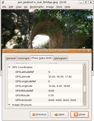
Geotagging, or GeoTagging, is the process of adding geographical identification metadata to various media such as a geotagged photograph or video, websites, SMS messages, QR Codes or RSS feeds and is a form of geospatial metadata. This data usually consists of latitude and longitude coordinates, though they can also include altitude, bearing, distance, accuracy data, and place names, and perhaps a time stamp.
Mobile content is any type of web hypertext and information content and electronic media which is viewed or used on mobile phones, like text, sound, ringtones, graphics, flash, discount offers, mobile games, movies, and GPS navigation. As mobile phone use has grown since the mid-1990s, the usage and significance of the mobile devices in everyday technological life has grown accordingly. Owners of mobile phones can now use their devices to make photo snapshots for upload, twits, mobile calendar appointments, and mostly send and receive text messages, listen to music, watch videos, take mobile pictures and make videos, use websites to redeem coupons for purchases, view and edit office documents, get driving instructions on mobile maps and so on. The use of mobile content in various areas has grown accordingly.
A tracking system, also known as a locating system, is used for the observing of persons or objects on the move and supplying a timely ordered sequence of location data for further processing. It is important to be aware of human tracking, further details are listed below.
gpsOne is the brand name for a cellphone chipset manufactured by Qualcomm for mobile phone tracking. It uses A-GPS or Assisted-GPS to locate the phone more quickly, accurately and reliably than by GPS alone, especially in places with poor GPS reception.
The Nike+iPod Sports Kit is an activity tracker device, developed by Nike, Inc., which measures and records the distance and pace of a walk or run. The Nike+iPod consists of a small transmitter device attached to or embedded in a shoe, which communicates with either the Nike+ Sportband, a receiver plugged into an iPod Nano. It can also work directly with a 2nd Generation iPod Touch, iPhone 3GS, iPhone 4, iPhone 4S, iPhone 5, iPhone 5C, iPhone 5S, or a Nike+ Sportwatch. If using the iPod or the iPhone, iTunes software can be used to view the walk or run history.
Loopt was a company based in Mountain View, California, United States which provided a service for smartphone users to share their location selectively with other people. The service supported iPhone, BlackBerry, Android and Windows Phones. Loopt's services had more than five million registered users and partnerships with every major U.S. mobile phone carrier. Their applications offered a variety of privacy controls. In addition to its core features, users also had the ability to integrate Loopt with other social networks, including Facebook and Twitter.

The HTC TyTN II is an Internet-enabled Windows Mobile Pocket PC smartphone designed and marketed by HTC Corporation of Taiwan. It has a tilting touchscreen with a right-side slide-out QWERTY keyboard. The TyTN II's functions include those of a camera phone and a portable media player in addition to text messaging and multimedia messaging. It also offers Internet services including e-mail, instant messaging, web browsing, and local Wi-Fi connectivity. It is a quad-band GSM phone with GPRS, EDGE, UMTS, HSDPA, and HSUPA.

The HTC Titan is a Windows Mobile 6.1 Pocket PC PDA and phone manufactured by High Tech Computer Corporation of Taiwan. It is the successor to the HTC Apache upon which it improves by adding more ROM, GPS, EVDO Rev. A, additional hard keys, a scroll-wheel, spring-loaded keyboard, and a higher resolution camera. The Windows Mobile 6.1 operating system includes Office Mobile along with HTML email through Microsoft Outlook Mobile. Windows Media Player is included, allowing the Titan to act as a digital audio and digital movie player.

A satellite navigation device is a user equipment that uses one or more of several global navigation satellite systems (GNSS) to calculate the device's geographical position and provide navigational advice. Depending on the software used, the satnav device may display the position on a map, as geographic coordinates, or may offer routing directions.

Navizon, Inc. is a provider of location-based services and products. Navizon was an early developer of technology that makes it possible to determine the geographic position of a mobile device using as reference the location of cell phone towers and Wi-Fi-based wireless access points instead of GPS. Navizon also developed technology for locating mobile devices indoors with room and floor-level accuracy.
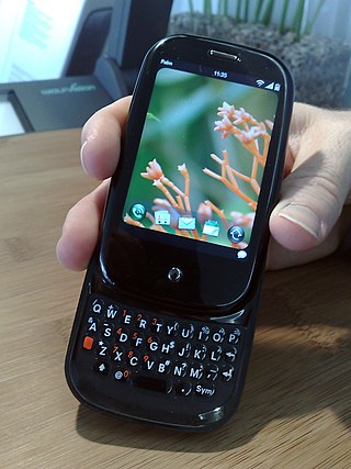
The Palm Pre, styled as palm prē, is a multitasking smartphone that was designed and marketed by Palm with a multi-touch screen and a sliding keyboard. The smartphone was the first to use Palm's Linux-based mobile operating system, webOS. The Pre functions as a camera phone and a portable media player, and has location and navigation capabilities. The Pre also serves as a personal information manager, has a number of communication and collaboration applications, and has Bluetooth and Wi-Fi connectivity built-in.
Sports Tracker, earlier Nokia Sports Tracker, was originally a software tool for Symbian Series 60 phones that allowed its user to track their route, speed, timings and energy expenditure, while engaging in a sport activity such as running, jogging or cycling.
Runkeeper is a GPS fitness-tracking app for iOS and Android launched in 2008. In late 2011, Runkeeper secured $10 million in a Series B financing, led by Spark Capital. In February 2016, Runkeeper was acquired by ASICS.
Azumio is a mobile health company that specializes in biometric mobile technology. Founded in 2011, Azumio develops Apple iOS and Android health apps and services. Azumio has released 24 apps on iOS, 5 apps on Android, and 3 apps on Windows Phone. The company is headquartered in Palo Alto, California.

Fitness, formerly Activity, is an exercise tracking companion app announced by Apple Inc. during their September 2014 Special Event. The app is available on iPhones running iOS 8.2 or above for users with a connected Apple Watch, later expanding to all iPhones regardless of Watch connectivity with the release of iOS 16. The application displays a summary view of user's recorded workouts from the Apple Watch or supported third-party apps and exercise equipment.
References
- ↑ "AllSport GPS is Shutting Down – Learning Center & Support for Trimble Outdoors". Archived from the original on 2017-07-06. Retrieved 2017-07-19.
- ↑ "REVIEW: Trimble's AllSport GPS Platinum tracks your trip but only so far - RCR Wireless News". Rcrnews.com. 2007-06-18. Archived from the original on 2011-07-20. Retrieved 2011-07-27.
- ↑ "is now TrimbleOutdoors.com - Frequently Asked Questions". Allsportgps.com. Archived from the original on August 2, 2008. Retrieved July 27, 2011.
- ↑ "Trimble News Release". Trimble.com. 2006-08-28. Archived from the original on 17 July 2011. Retrieved 2011-07-27.
- ↑ http://pdasoftwareaccessories.cell-iphone-voip.com/pda/blackberry-gps/blackberry-gps-you-have-a-choice-of-using-internal-or-external-gps-receivers/ [ dead link ]
- ↑ "AT&T- News Room". Att.com. 2008-11-05. Retrieved 2011-07-27.
- ↑ "On the Run with Trimble Outdoors AllSport GPS – Cell Phones & Mobile Device Technology News & Updates". Geek.com. 2007-01-04. Archived from the original on 2008-06-03. Retrieved 2011-07-27.
- ↑ "Gifts Ideas That Find Themselves". The New York Times. 2007-12-04. Retrieved 2010-04-23.
- ↑ "GeoCarta: GPS Gadget of the Week: AllSport GPS". Geocarta.blogspot.com. 2007-03-17. Archived from the original on 22 July 2011. Retrieved 2011-07-27.
- ↑ "Trimble Outdoors AllSportGPS, a review of Trimble Outdoors AllSportGPS". Laptopmag.com. 2007-07-02. Archived from the original on 22 July 2011. Retrieved 2011-07-27.