Almirantazgo Fjord

Last updated
Riesco Island, R N Alacalufes Riesco I.JPG
Riesco Island, R N Alacalufes
South America southern tip pol.png

{{{annotations}}}

South America southern tip pol.png
Almirantazgo Fjord in Tierra del Fuego (right, marked as Seno Almirantazgo).

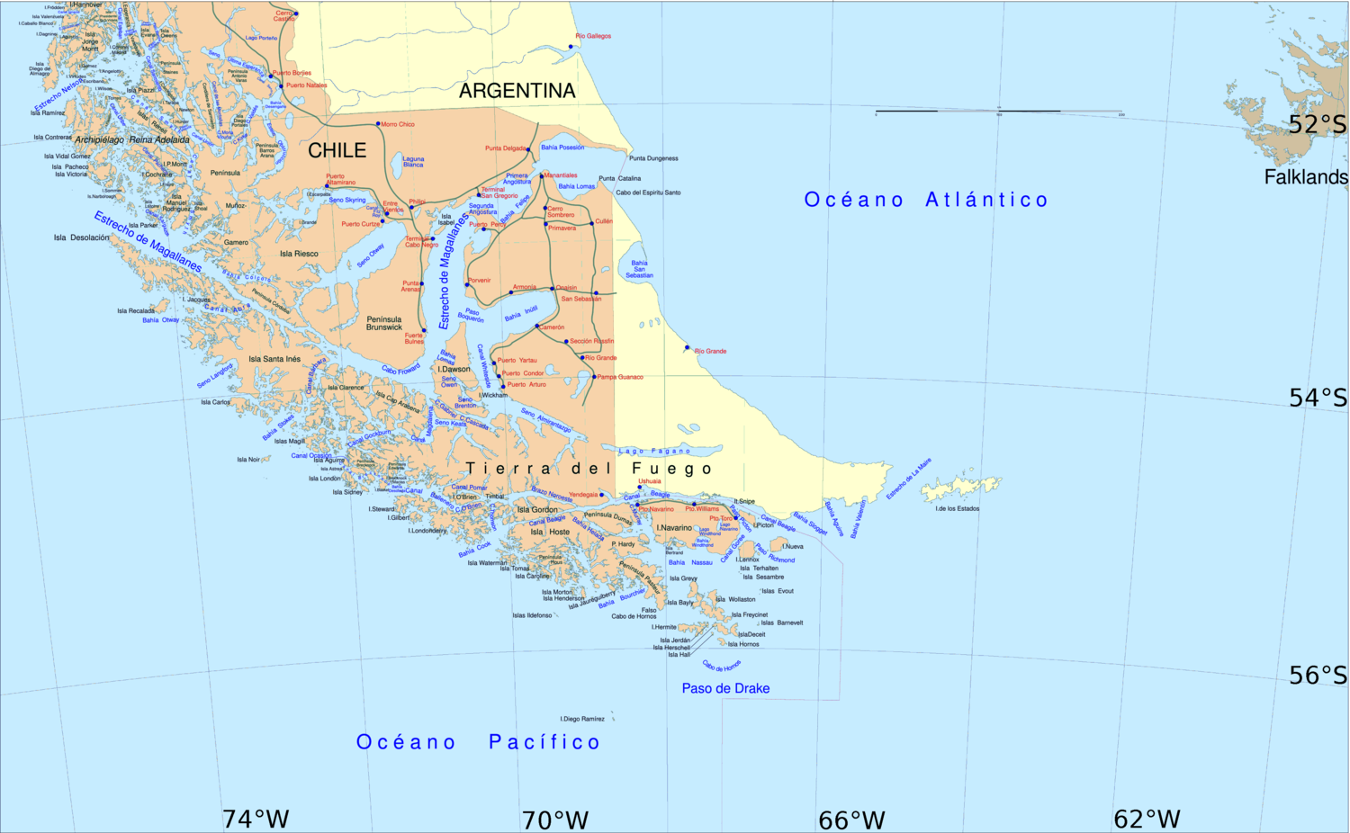
Almirantazgo Fjord (Spanish : Fiordo Almirantazgo), also known as Almirantazgo Sound (Spanish : Seno Almirantazgo) or Admiralty Sound, [1] is a Chilean fjord located in the far south of the country at 54°19′S69°30′W / 54.317°S 69.500°W / -54.317; -69.500 . [2] The fjord cuts deeply into the west coast of the Isla Grande de Tierra del Fuego, extending southeastwards from the Whiteside Channel, which separates Isla Grande from Dawson Island. On its south side several smaller fjords and bays make significant indentations into the north coastline of the Cordillera Darwin. [3] One of these, Ainsworth Bay, is home to a colony of elephant seals. [4] Azopardo River empties into the head of the fjord.

Contents

The sound was discovered in 1827 by the British Captain Phillip Parker King and named after the British Admiralty. [5]

Geography

Ainsworth Bay, fed by the meltwater of Marinelli Glacier is a notable inlet along the Almirantazgo Fjord. The Marinelli Glacier has been in a state of retreat since at least 1960, and the retreat continues to the present time of 2008. [6]

See also

Related Research Articles

<span class="mw-page-title-main">Tierra del Fuego</span> Archipelago off the south of South America

Tierra del Fuego is an archipelago off the southernmost tip of the South American mainland, across the Strait of Magellan. The archipelago consists of the main island, Isla Grande de Tierra del Fuego, with an area of 48,100 km2 (18,572 sq mi), and a group of many islands, including Cape Horn and Diego Ramírez Islands. Tierra del Fuego is divided between Chile and Argentina, with the latter controlling the eastern half of the main island and the former the western half plus the islands south of Beagle Channel and the southernmost islands. The southernmost extent of the archipelago is just north of latitude 56°S.

<span class="mw-page-title-main">Strait of Magellan</span> Strait in southern Chile joining the Atlantic and Pacific oceans

The Strait of Magellan, also called the Straits of Magellan, is a navigable sea route in southern Chile separating mainland South America to the north and Tierra del Fuego to the south. The strait is considered the most important natural passage between the Atlantic and Pacific oceans. It was discovered and first traversed by the Spanish expedition of Ferdinand Magellan in 1520, after whom it is named. Prior to this, the strait had been navigated by canoe-faring indigenous peoples including the Kawésqar.

<span class="mw-page-title-main">Tierra del Fuego Province, Argentina</span> Province in Ushuaia, Argentina

Tierra del Fuego, officially the Province of Tierra del Fuego, Antarctica and South Atlantic Islands, is the southernmost, smallest, and least populous Argentine province.

<span class="mw-page-title-main">Isla Grande de Tierra del Fuego</span> Island of Argentina and Chile

Isla Grande de Tierra del Fuego also formerly Isla de Xátiva is an island near the southern tip of South America from which it is separated by the Strait of Magellan. The western portion (61.4%) of the island is in Chile, while the eastern portion is in Argentina. It forms the major landmass in an extended group of islands or archipelago also known as Tierra del Fuego.

<span class="mw-page-title-main">Beagle Channel</span> Strait in Tierra del Fuego

Beagle Channel is a strait in the Tierra del Fuego Archipelago, on the extreme southern tip of South America between Chile and Argentina. The channel separates the larger main island of Isla Grande de Tierra del Fuego from various smaller islands including the islands of Picton, Lennox and Nueva; Navarino; Hoste; Londonderry; and Stewart. The channel's eastern area forms part of the border between Chile and Argentina and the western area is entirely within Chile.

<span class="mw-page-title-main">Mount Darwin (Andes)</span> Mountain in Chile

Mount Darwin is a peak in Isla Grande de Tierra del Fuego forming part of the Cordillera Darwin, the southernmost range of the Andes, just to the north of the Beagle Channel.

<span class="mw-page-title-main">Tierra del Fuego Province, Chile</span> Province in Magallanes y Antártica Chilena, Chile

Tierra del Fuego Province is one of four provinces in the southern Chilean region of Magallanes and Antártica Chilena (XII). It includes the Chilean or western part of the main island of Tierra del Fuego, except for the part south of the Cordillera Darwin, which is in Antártica Chilena Province.

<span class="mw-page-title-main">Cami Lake</span> Body of water

Fagnano Lake, also called Lake Cami, is a lake located on the main island of the Tierra del Fuego archipelago, and shared by Argentina and Chile. The 645 km2 lake runs east–west for about 98 kilometres, of which 72.5 km (606 km2) belong to the Argentine Tierra del Fuego Province, and only 13.5 km (39 km2) belong to the Chilean Magallanes y la Antártica Chilena Region. It has a maximum depth of 449 meters. The southern bank is steep compared to the northern, and expands in a considerably wide and flat piedmont from which both levels of the plateaus can be appreciated. From its western end, the Azopardo River drains towards the Almirantazgo Fjord. On its eastern end is the town of Tolhuin. The lake is located in a pull-apart basin developed along the Magallanes–Fagnano Fault zone.

<span class="mw-page-title-main">Alberto de Agostini National Park</span>

Alberto de Agostini National Park is a protected area that was created on January 22, 1965, on land that was formerly part of the "Hollanda" forest reserve and "Hernando de Magallanes National Park". It covers 1,460,000 hectares and includes the Cordillera Darwin mountain range, which is the final land-based stretch of the Andes before it becomes a chain of mountains appearing as small islands that sink into the Pacific Ocean and the Beagle Channel.

The Cordillera Darwin is an extensive mountain range mantled by an ice field that is located in Chile.

<span class="mw-page-title-main">Zona Austral</span> Southernmost natural region of continental Chile

The Zona Austral is one of the five natural regions into which CORFO divided continental Chile in 1950 corresponding to the Chilean portion of Patagonia. It is surrounded by the Zona Sur and the Chacao Channel to the north, the Pacific Ocean and Drake's Passage to the south and west, and the Andean mountains and Argentina to the east. If excluding Chiloé Archipelago Zona Austral covers all of Chilean Patagonia.

<span class="mw-page-title-main">Azopardo River</span> River in Chile

The Azopardo River, is a river in Isla Grande de Tierra del Fuego, Chile at the southern tip of South America. It flows in a westerly direction and drains the waters of Fagnano Lake into Almirantazgo Fjord.

<span class="mw-page-title-main">Agostini Fjord</span>

Agostini Fjord, also known as Agostini Sound, is a fjord in Tierra del Fuego that separates two branches of the Cordillera Darwin, the Cordón Navarro in the southwest and the mountain range that includes Monte Buckland in the northeast. It is named after the Italian explorer Alberto María de Agostini. The latter range contains some of the most rugged peaks in southern Chile and the former is a mostly ice-covered range. It connected to Magdalena Channel via Keats Sound.

<span class="mw-page-title-main">Magdalena Channel</span>

Magdalena Channel is a Chilean channel joining the Strait of Magellan with the Cockburn Channel and is part of a major navigation route which ultimately connects with the Beagle Channel. It separates Capitán Aracena Island from the westernmost portion of Isla Grande de Tierra del Fuego, and crosses Alberto de Agostini National Park. It is flanked by mountains, the chief of which is Monte Sarmiento. Like the Abra Channel and the Bárbara Channel farther west, it joins the western part of the Strait of Magellan directly to the Pacific Ocean.

<span class="mw-page-title-main">Marinelli Glacier</span>

Marinelli Glacier is a tidewater glacier located in Alberto de Agostini National Park, Isla Grande de Tierra del Fuego. The glacier spills out from the backbone of the Cordillera Darwin and calves into Ainsworth Bay, an embayment of the Almirantazgo Fjord. The Marinelli Glacier is in a state of retreat, beginning at least as early as 1960 and continuing to the present time. Meltwater of Marinelli glacier discharges to form the headwaters of Marinelli Creek.

<span class="mw-page-title-main">Ainsworth Bay (Chile)</span>

Ainsworth Bay in the Tierra del Fuego region of Chile is a coastal inlet fed by the meltwater of Marinelli Glacier. The Marinelli Glacier is in a state of retreat.

Marinelli Creek is a watercourse whose headwaters emerge from the melting of Marinelli Glacier in Tierra del Fuego, Chile. Marinelli Creek discharges to Ainsworth Bay, a notable inlet along the Almirantazgo Fjord. The Marinelli Glacier has been in a state of retreat since at least 1943, and the retreat continues to the present time of 2008.

<span class="mw-page-title-main">Martial Mountains</span> Mountain range in Argentina and Chile

The Martial Mountains are a mountain range in Isla Grande de Tierra del Fuego, an island of Argentina and Chile. The mountain range is located east of Cordillera Darwin, just north of Ushuaia city in Argentina, along the Beagle Channel strait.

<span class="mw-page-title-main">Canal Whiteside</span>

Canal Whiteside or Whiteside Channel is a channel in southern Chile, between Dawson Island and Isla Grande de Tierra del Fuego. It runs from the southern tip of Inútil Bay to Almirantazgo Fjord. It is clear of dangers and deep; the eastern shore, which is low and fronted with shallow water, should not be approached within one mile; the western shore has no known dangers off-lying, and may be approached to a distance of about 1/4 mile.

<span class="mw-page-title-main">Cockburn Channel</span> Body of water

The Cockburn Channel is a channel that separates the Brecknock Peninsula, which is the westernmost projection of the Isla Grande de Tierra del Fuego, from Clarence Island, Capitán Aracena Island and other minor islands in Chile. It is located at 54°20′S71°30′W and extends 40 miles (64 km) east from the open Pacific Ocean to Magdalena Channel. The channel is part of a major waterway connecting the Strait of Magellan to the Beagle Channel: Magdalena Channel, Cockburn Channel, Brednock Pass, Ballenero Channel, Beagle Channel.

References

  1. Geonames
  2. Earth Info, earth-info.nga.mil webpage: "GNS: Country Files". Archived from the original on 2012-05-04. Retrieved 2012-05-05..
  3. USGS. "Tierra del Fuego map" . Retrieved 2007-10-05.
  4. (in Spanish) Proyecto Gef marino en Chile - AMCP-MU Archived 2008-01-28 at the Wayback Machine
  5. Murray, Hugh (1834). An Encyclopaedia of Geography. Longman. p.  1433.
  6. C. Michael Hogan. 2008 Bahia Wulaia Dome Middens, Megalithic Portal, ed. Andy Burnham