
Yosemite National Park is an American national park located in the western Sierra Nevada of Central California, bounded on the southeast by Sierra National Forest and on the northwest by Stanislaus National Forest. The park is managed by the National Park Service and covers an area of 748,436 acres and sits in four counties: centered in Tuolumne and Mariposa, extending north and east to Mono and south to Madera County. Designated a World Heritage Site in 1984, Yosemite is internationally recognized for its granite cliffs, waterfalls, clear streams, giant sequoia groves, lakes, mountains, meadows, glaciers, and biological diversity. Almost 95% of the park is designated wilderness.

Mono County (MOH-noh) is a county located in the east central portion of the U.S. state of California. As of the 2010 census, the population was 14,202. making it the fifth-least populous county in California. The county seat is Bridgeport. The county is located east of the Sierra Nevada between Yosemite National Park and Nevada.

Tioga Pass is a mountain pass in the Sierra Nevada of California. State Route 120 runs through it, and serves as the eastern entry point for Yosemite National Park, at the Tioga Pass Entrance Station. It is the highest highway pass in California and in the Sierra Nevada. Mount Dana is to the east of the pass. There are several trailheads into the Yosemite backcountry which begin at Tioga Pass, including the trail to the Gaylor Lakes to the west/northwest, and the rough trail to the summit of Mount Dana. Dana Meadows is immediately south of the pass alongside the highway, as the pass itself is roughly angled north/south as opposed to east/west. Dana Meadows contains several small lakes.

Sierra National Forest is a U.S. National Forest located on the western slope of central Sierra Nevada in Central California and bounded on the northwest by Yosemite National Park and the south by Kings Canyon National Park. The forest is known for its mountain scenery and natural resources. Forest headquarters are located in Clovis, California. There are local ranger district offices in North Fork and Prather.
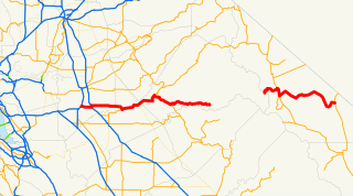
State Route 120 is a state highway in the U.S. state of California, running west to east across the central part of the state. It runs from Interstate 5 in the San Joaquin Valley near Lathrop through Yosemite National Park, to its end at U.S. Route 6 in Mono County, eastern California. While the route is signed as a contiguous route through Yosemite National Park, the portion in park boundaries is federally maintained, and is not included in the state route logs. The portion at Tioga Pass is the highest paved through road in the California State Route system. This part is not maintained in the winter and is usually closed during the winter season.

Lee Vining is a census-designated place in Mono County, California, United States. It is located 21 miles (34 km) south-southeast of Bridgeport, at an elevation of 6781 feet. Lee Vining is located on the southwest shore of Mono Lake. The population was 222 as of the 2010 census, down from 250 reported as of 2000 by Mono County. At the previous census (1990) the town population was 398, and at the census before that (1980) it was 315.
Tenaya was a leader of the Ahwahnechee people in Yosemite Valley, California.
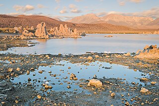
Mono Lake Tufa State Natural Reserve is located near Yosemite National Park within Mono County, in eastern California. It was established in 1981 by the California State Legislature to preserve the natural limestone "tufa tower" formations at Mono Lake.

Inyo National Forest is a United States National Forest covering parts of the eastern Sierra Nevada of California and the White Mountains of California and Nevada. The forest hosts several superlatives, including Mount Whitney, the highest point in the contiguous United States; Boundary Peak, highest point in Nevada; and the Ancient Bristlecone Pine Forest that protects the oldest trees in the world. The forest, encompassing much of Owens Valley, was established by Theodore Roosevelt as a way of sectioning off land to accommodate the Los Angeles Aqueduct project in 1907, making the Inyo National Forest one of the least wooded forests in the United States' system.
Conway Summit is a mountain pass in Mono County, California. It is traversed by U.S. Highway 395, which connects Bridgeport and the East Walker River on the north side of the pass to Mono Lake and Lee Vining to the south. It marks the highest point on U.S. 395, which also traverses high passes at Deadman Summit and Devil's Gate Pass.

Lundy is a defunct community in Mono County, California, United States, located on Mill Creek in Lundy Canyon near the west end of Lundy Lake. It is situated at an elevation of 7858 feet. It was named after W.J. Lundy who operated a sawmill near Lundy Lake. The sawmill was a major timber producer for the nearby town of Bodie, California. Lundy also had a mining camp that was established in 1879. The Lundy post office ran from 1880–1914.
Leavitt Peak is located in the Emigrant Wilderness near Sonora Pass in the eastern Sierra Nevada range of California. Leavitt Peak is located on the Tuolumne County - Mono County line. The Pacific Crest Trail runs close to the east of Leavitt Peak, at an elevation of about 10,800 feet (3,290 m) elevation. The peak offers views south to Yosemite National Park and north towards South Lake Tahoe.

Mono Hot Springs is a summer resort, campground, unincorporated community, and a group of hot springs in Fresno County, central California. It is located within the Sierra National Forest, 70 miles (110 km) northeast of Fresno via California State Route 168.

Mono Village is a former settlement in Mono County, California. It was located 11 miles (18 km) southwest of Bridgeport, at an elevation of 7142 feet. It is currently a vacation destination that attracts hundreds of fishermen and outdoor enthusiasts every year. It is a full service destination with a camp ground, motel, cabins, grocery store, cafe, and other amenities. The main attraction is the two lakes known as Twin Lakes. Both of these lakes are filled with water from Robinson's Creek which flows down from the top of the mountains and ends at the Bridgeport Reservoir. It has some of the best trout fishing in California with record size fish being caught there. Both lakes have boat access and the Upper Twin allows for water sports. Mono Village is also a starting off point for many back country hiking trails. It sits on the back side of Yosemite which makes it attractive to expert backpackers and horseback tours.

Kuna Peak is a summit on the boundary between Mono and Tuolumne counties, in the United States, is the highest point on Kuna Crest. With an elevation of 13,008 feet (3,965 m), Kuna Peak is the 146st-highest summit in the state of California, and is the third-highest mountain in Yosemite National Park.

Agnew Lake is a lake in Mono County, California, in the United States.

The Alger Lakes are a group of lakes in Mono County, California, in the United States.

Alger Creek is a stream in Mono County, California, in the United States.
The Conness Lakes are a group of small lakes at the foot of Conness Glacier in Mono County, California, in the United States.


