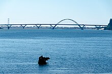
44°26′16″N124°03′00″W / 44.4377°N 124.0501°W Alsea Bay is a body of water near Waldport, Oregon at the mouth of the Alsea River. It is a site for beach angling. [1] It is spanned by the Alsea Bay Bridge and is in Lincoln County, Oregon.
44°26′16″N124°03′00″W / 44.4377°N 124.0501°W Alsea Bay is a body of water near Waldport, Oregon at the mouth of the Alsea River. It is a site for beach angling. [1] It is spanned by the Alsea Bay Bridge and is in Lincoln County, Oregon.
Waldport is a city in Lincoln County, Oregon, United States. The population was 2,033 at the 2010 census. The city is located on the Alsea River and Alsea Bay, 15 miles (24 km) south of Newport and 8 miles (13 km) north of Yachats.

Yachats is a small coastal city in the southernmost area of Lincoln County, Oregon, United States. According to Oregon Geographic Names, the name comes from the Siletz language and means "dark water at the foot of the mountain". There is a range of differing etymologies. William Bright says the name comes from the Alsea placename yáx̣ayky. At the 2010 census, the city's population was 690.

The Oregon Coast is a coastal region of the U.S. state of Oregon. It is bordered by the Pacific Ocean to its west and the Oregon Coast Range to the east, and stretches approximately 362 miles (583 km) from the California state border in the south to the Columbia River in the north. The region is not a specific geological, environmental, or political entity, and includes the Columbia River Estuary.

The Alsea River flows 48.5 miles (78.1 km) from Alsea, an unincorporated community in the coastal mountains of the U.S. state of Oregon, to the Pacific Ocean near the city of Waldport. It begins at the confluence of the North Fork Alsea River and the South Fork Alsea River and ends in Alsea Bay, a wide estuary at Waldport. The river flows generally west-northwest in a winding course through the mountains of southern Benton and Lincoln counties, passing near the unincorporated community of Tidewater and through the Siuslaw National Forest. Its drainage basin extends into Lane County, along the headwaters of the South Fork Alsea River.

The Alsea Bay Bridge is a concrete arch bridge that spans the Alsea Bay on U.S. Route 101 (US 101) near Waldport, Oregon.

The Oregon Coast Trail (OCT) is a long-distance hiking route along the Pacific coast of the U.S. state of Oregon in the United States. It follows the coast of Oregon from the mouth of the Columbia River to the California border south of Brookings.

Oregon Route 34 is a state highway in the U.S. state of Oregon that runs between the city of Waldport on the Oregon Coast and the city of Lebanon in the western part of the state. OR 34 traverses the Alsea Highway No. 27 from Waldport to Flynn, part of the Corvallis–Newport Highway No. 33 from Flynn to east of Corvallis, and the Corvallis–Lebanon Highway No. 210 from east of Corvallis to Lebanon, of the Oregon state highway system. In Corvallis, OR 34 includes a brief concurrency with U.S. Route 20 and OR 99W over the Pacific Highway West No. 1W.
The Alsea are a Native American tribe of Oregon. Alsea may also refer to:

Tidewater is an unincorporated community in Lincoln County, Oregon, United States located on the Alsea River east of Waldport on Oregon Route 34.

Moolack Beach is an undeveloped sandy beach on the Oregon Coast about 4 miles (6 km) north of Newport in Lincoln County, United States. It is almost 8 km (5 mi) in length with the south end at Yaquina Head and the north end at Otter Rock, the site of Devils Punch Bowl State Natural Area. The northern beach is the site of Beverly Beach State Park and the community of Beverly Beach. The beach has no obvious break delineating what would seem to be Beverly Beach, though Wade Creek is a likely candidate. The nearly ten-foot (3-metre) tidal range and seasonally varying slope of the beach can cause the sandy beach to completely disappear at times; at other times it can be hundreds of feet wide. The beach is bounded by U.S. Route 101.

Cape Perpetua is a large forested headland projecting into the Pacific Ocean on the central Oregon Coast in Lincoln County, Oregon. The land is managed by the United States Forest Service as part of the Siuslaw National Forest.
Fisher is an unincorporated community in rural Lincoln County, Oregon, United States. Fisher lies along Five Rivers Road, 9.2 miles (14.8 km) south of its intersection with Oregon Route 34. It is slightly north of the Lincoln–Lane county line in the Siuslaw National Forest. A stream called Five Rivers flows west through Fisher, about 12 miles (19 km) by water from the stream's mouth on the Alsea River. Route 34 runs along the Alsea River between Alsea and Waldport.
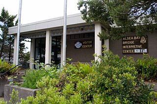
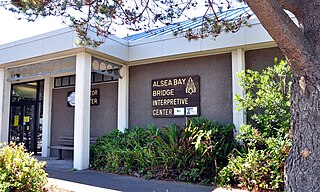
Alsea Bay Historic Interpretive Center is a public facility in Waldport, Oregon, administered and owned by the city of Waldport. It is adjacent to the Alsea Bay Bridge and was constructed by the Oregon Department of Transportation as part of the bridge replacement project. It was transferred to the city on Oct 8th, 2020 from the Oregon Department of Transportation.

W. B. Nelson State Recreation Site is a state park in Lincoln County, western Oregon.
The Red River is a stream approximately 1 mile (2 km) long in Lincoln County in the northwestern U.S. state of Oregon. It rises south of downtown Waldport and flows through the city to meet the Alsea River near the larger river's mouth on the Pacific Ocean.
Five Rivers is a tributary of the Alsea River in the U.S. state of Oregon, in Lane, Lincoln, Benton counties. The name Five Rivers refers to the relative importance to the stream of five of its tributaries: Alder, Cougar, Buck, Crab, and Cherry creeks.

Nye Beach is a central district in Newport in the U.S. state of Oregon. The Nye Beach historic overlay district is bounded on the north and south sides by Northwest Twelfth Street and Southwest Second Street respectively; on the east side by Hurbert Street and on the west side by the Pacific Ocean. Situated on a sea cliff, the district has been a popular vacation spot since the late 19th century. Cultural and literary groups such as Oregon Coast Council for the Arts, Yaquina Art Association, and Writers on the Edge are based in Nye Beach, as are Newport's Performing Arts and Visual Arts Centers. The beach attracts tide-pool enthusiasts and beachcombers as well as surfers, sail-boarders, crabbers, clam diggers, kite flyers, photographers, and artists and has also been the site of marine and geological research projects.
Paris is an unincorporated community in Lane County, in the U.S. state of Oregon. It is a rural locale in the Central Oregon Coast Range north of the Siuslaw River and south of the Alsea River along one of its tributaries, Five Rivers. Paris is located at 44°15′09″N123°46′14″W.
David Anthony Durham is an American wanted fugitive who disappeared under mysterious circumstances after shooting and critically injuring a police officer during a traffic stop in Lincoln City, Oregon. After shooting the officer, Durham's vehicle was rendered inoperable via a spike strip 40 miles (64 km) south in Waldport, where he fled on foot and began shooting at a crab fisherman in Alsea Bay before disappearing. Durham's whereabouts remain unknown.
Bayshore is an unincorporated community and census-designated place (CDP) in Lincoln County, Oregon, United States. It was first listed as a CDP prior to the 2020 census.