Alt Pirineu Natural Park

Last updated
Alt Pirineu Natural Park
Parc Natural de l'Alt Pirineu
IUCN category V (protected landscape/seascape)
Parc Natural de l'Alt Pirineu.svg
Parc natural de l'alt pirineu.jpg
Catalonia location map.svg
Red pog.svg
Location of the natural park in Catalonia
Location Province of Lleida, Catalonia, Spain
Coordinates 42°29′46″N1°12′38″E / 42.49611°N 1.21056°E / 42.49611; 1.21056 Coordinates: 42°29′46″N1°12′38″E / 42.49611°N 1.21056°E / 42.49611; 1.21056
Area69,850 hectares (172,600 acres)
Established2003 (2003)
Governing body Generalitat de Catalunya
www.gencat.cat/parcs/alt_pirineu

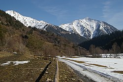
Alt Pirineu Natural Park (Catalan : Parc Natural de l'Alt Pirineu) is the largest natural park in Catalonia, Spain. The park was established in 2003 by the Generalitat de Catalunya and covers an area of 69,850 hectares (172,600 acres), including the highest peaks of the Pyrenees in Catalonia. It stretches over the comarques of Pallars Sobirà and Alt Urgell. [1] [2]

Related Research Articles

Catalonia Autonomous community in northeastern Spain

Catalonia is an autonomous community of Spain, designated as a nationality by its Statute of Autonomy.

La Seu dUrgell Municipality in Catalonia, Spain

La Seu d'Urgell is a town located in the Catalan Pyrenees in Spain. La Seu d'Urgell is also the capital of the comarca Alt Urgell, head of the judicial district of la Seu d'Urgell and the seat of Bishop of Urgell, one of the Andorra co-princes. It is in the district of Alt Pirineu i Aran, and is the town with the most inhabitants, having 17.4% of the district population. La Seu d'Urgell and Puigcerdà together have 30% of the population of the area.

Pallars Sobirà Comarca in Catalonia, Spain

Pallars Sobirà is a comarca in the mountainous northwest of Catalonia, Spain. The name means "Upper Pallars", distinguishing it from the more populous Pallars Jussà to its southwest. Its capital and largest municipality is Sort.

Province of Lleida Province of Spain

The Province of Lleida is one of the four provinces of Catalonia. It lies in north-eastern Spain, in the western part of the autonomous community of Catalonia, and is bordered by the Provinces of Girona, Barcelona, Tarragona, Zaragoza and Huesca and the countries of France and Andorra. It is often popularly referred to as Ponent.

Cerdanya (comarca) Comarca in Catalonia, Spain

Cerdanya is a comarca in northern Catalonia, in the Pyrenees, on the border of Catalonia with France and Andorra. Within Catalonia, Cerdanya is divided between Catalan provinces of Girona and Lleida. Cerdanya's neighbouring comarques are Alt Urgell, Berguedà, and Ripollès.

Camp de Tarragona Region of Catalonia, Spain

Camp de Tarragona is a natural and historical region of Catalonia, Spain. It includes a central plain, surrounded by the Serralada Prelitoral mountain chain on the west and in the north, with the Mediterranean sand beaches of the Costa Daurada on the east and limited in the south by the Coll de Balaguer. The main towns are Tarragona, Reus, Valls and Cambrils. Salou is an important resort destination.

Pica dEstats

Pica d'Estats is a 3,143-metre-high (10,312 ft) mountain in the Montcalm Massif, Pyrenees. on the Spanish–French border, and is the highest mountain in Catalonia.

Fígols i Alinyà Municipality in Catalonia, Spain

Fígols i Alinyà is a municipality in the comarca of the Alt Urgell in Catalonia, Spain. It is situated on the left bank of the Segre river between Coll de Nargó and Organyà, just above the Oliana reservoir. The municipality was formed in 1972 by the merger of the municipalities of Fígols d'Organyà and Alinyà: the ajuntament is in Fígols. A local road links the municipality with Organyà.

Montferrer i Castellbò Municipality in Catalonia, Spain

Montferrer i Castellbò is a municipality in the comarca of Alt Urgell, Lleida, Catalonia, Spain.

Alt Pirineu i Aran

Alt Pirineu i Aran is one of the seven vegueries (territories) defined by the Regional Plan of Catalonia. It is located in the Catalan High Pyrenees.

Àmbit metropolità de Barcelona

Àmbit metropolità de Barcelona is one of the seven territories defined by the Regional Plan of Catalonia. It is located in the central coast of Catalonia, in Barcelona and its influence area.

Lleida–La Pobla Line

The Lleida–La Pobla Line is a 89.4-kilometre-long (55.6 mi) railway line linking Lleida and La Pobla de Segur, in Catalonia, Spain. Most of its users concentrate between Lleida and Balaguer, where a frequent service is offered, with few trains continuing to La Pobla de Segur. Since 2009, a heritage railway service branded Tren dels Llacs, in reference to the number of reservoirs skirted by the line north of Balaguer, has been running on the railway. The line is part of the ATM Àrea de Lleida fare-integrated public transport system between Lleida and Àger.

Lleida Pirineus railway station

Lleida Pirineus is an important railway station serving the city of Lleida in Catalonia, Spain. It is located between the neighbourhoods of Pardinyes and Rambla de Ferran. The first train services in Lleida date of 1860, but the station wasn't built until 1927, and it did not adopt its current official name until 2003, when it underwent an ambitious reform. As a transport hub connecting the interior of Spain with the Corredor Mediterráneo, it serves both broad gauge and standard gauge trains, operated by both Adif-Renfe and Ferrocarrils de la Generalitat de Catalunya. It is the terminus of several regional railway services centered in Aragon and Catalonia. It's also one of the stations on the Madrid–Barcelona high-speed rail line, and it was its north-eastern terminus until 2008.

Rail transport in Catalonia Railway system in Catalonia

Rail transport in Catalonia operates on three rail gauges and services are operated by a variety of public operators:

Ponent Territory in Catalonia

Ponent, Lleida or Terres de Lleida is one of the seven territories defined by the Regional Plan of Catalonia. It is not clear what name will have, being all of them traditionally accepted names for the region.

Outline of Catalonia Overview of and topical guide to Catalonia

The following outline is provided as an overview of and topical guide to Catalonia:

Pic Verdaguer or Pic de Verdaguer is a mountain of the Montcalm Massif. Located in the Pyrenees, at the border between France and Spain, it has an altitude of 3,129 metres (10,266 ft) above sea level.

Punta Gabarró

Punta Gabarró or Punta de Gabarró is a mountain of the Montcalm Massif. Located in the Pyrenees, at the border between France and Spain, it has an elevation of 3,105 metres (10,187 ft) above sea level.

Montcalm Massif Mountain massif in the Pyrenees

The Montcalm Massif is a mountain massif located in the Pyrenees, at the border between France and Spain, it has an altitude of 3077 metres above sea level.

Pep Coll Spanish writer

Josep Coll i Martí, better known as Pep Coll, is a Spanish writer. A prolific author, he has cultivated all literary genres, including journalism. His life and literary world are the Pyrenees, which have become a legendary universe. His works have been translated into several languages, including Spanish and Basque. In addition to his work as a writer, he has been teacher of language and literature.

References

  1. "Alt Pirineu Natural Park". Diputació de Lleida - ARA LLEIDA. lleidatur.com. Retrieved February 5, 2012.
  2. Marta Pallarès (December 31, 2004). "PARC NATURAL DE L'ALT PIRINEU". Observatori de projectes i debats territorials de Catalunya (in Catalan). scot.cat. Retrieved February 5, 2012.