
Orange County, often known by its initials O.C., is a county located in the Los Angeles metropolitan area in Southern California, United States. As of the 2020 census, the population was 3,186,989, making it the third-most-populous county in California, the sixth-most-populous in the United States, and more populous than 19 American states and Washington, D.C. Although largely suburban, it is the second-most-densely-populated county in the state behind San Francisco County. The county's three most-populous cities are Anaheim, Santa Ana, and Irvine, each of which has a population exceeding 300,000. Santa Ana is also the county seat. Six cities in Orange County are on the Pacific coast: Seal Beach, Huntington Beach, Newport Beach, Laguna Beach, Dana Point, and San Clemente.

Southern California is a geographic and cultural region that generally comprises the southern portion of the U.S. state of California. It includes the Los Angeles metropolitan area and also the Inland Empire. The region generally contains ten of California's 58 counties: Imperial, Kern, Los Angeles, Orange, Riverside, San Bernardino, San Diego, Santa Barbara, San Luis Obispo and Ventura counties.
Signal Hill is a city 2.2 sq mi (5.7 km2) in area in Los Angeles County, California. Located high on a hill, the city is an enclave completely surrounded by the city of Long Beach. Signal Hill was incorporated on April 22, 1924, roughly three years after oil was discovered there. As of the 2010 census, the city population was 11,016.

Laguna Beach is a city in Orange County, California, United States. Located in Southern California along the Pacific Ocean, this seaside resort city has a mild year-round climate, scenic coves, and environmental preservation efforts. The population in the 2020 census was 23,032.

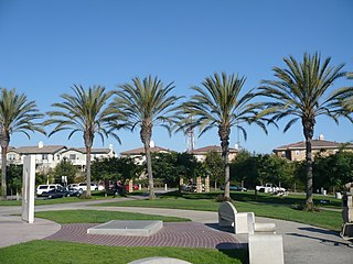
Laguna Niguel is a city in Orange County, California, United States. The name Laguna Niguel is derived from the words "Laguna" and "Niguili". As of the 2020 census, the population was 64,355. Laguna Niguel is located in the San Joaquin Hills in the southeastern corner of Orange County, close to the Pacific Ocean, and borders the cities of Aliso Viejo, Dana Point, Laguna Beach, Laguna Hills, Mission Viejo, and San Juan Capistrano.

The Orange Coast is the string of cities and neighborhoods fronting the Pacific Coast in Orange County, California. From northwest to southeast, these cities are Seal Beach, Huntington Beach, Newport Beach, Laguna Beach, Dana Point and San Clemente. There are also two small unincorporated areas, a portion of Crystal Cove State Park between Newport Beach and Laguna Beach and Emerald Bay, a gated community located between two neighborhoods of Laguna Beach.

Forest Hill is a neighborhood in San Francisco, California. Forest Hill is one of eight master-planned residence parks in San Francisco. Forest Hill is located near the middle of the City of San Francisco, southeast of the Inner Sunset and northeast of West Portal. Boundaries are roughly Seventh Avenue/Laguna Honda Boulevard to the north and east, Taraval Street to the south, and 14th Avenue to the west.

University Hills is a neighborhood on the East Side of Los Angeles, California. It consists of the residential areas surrounding California State University, Los Angeles.
California's 48th congressional district is a congressional district in the U.S. state of California based in San Diego County in Southern California. It is currently represented by Republican Darrell Issa.

The Laguna Art Museum (LAM) is a museum located in Laguna Beach, California, on Pacific Coast Highway. LAM exclusively features California art and is the oldest cultural institution in the area. It has been known as the Laguna Beach Art Association, as well as the Laguna Beach Museum of Art.

Telegraph Hill is a hill and surrounding neighborhood in San Francisco, California. It is one of San Francisco's 44 hills, and one of its original "Seven Hills".

California's 47th congressional district is a congressional district in the U.S. state of California.

The San Joaquin Hills are a low mountain range of the Peninsular Ranges System, located in coastal Orange County, California.
The Southern California Association of Governments (SCAG) is the Metropolitan Planning Organization (MPO) of six of the ten counties in Southern California, serving Imperial County, Los Angeles County, Orange County, Riverside County, San Bernardino County, and Ventura County. San Diego County's MPO is the San Diego Association of Governments, which is an unrelated agency.

Aliso Creek is a 19.8-mile (31.9 km)-long, mostly urban stream in south Orange County, California. Originating in the Cleveland National Forest in the Santa Ana Mountains, it flows generally southwest and empties into the Pacific Ocean at Laguna Beach. The creek's watershed drains 34.9 square miles (90 km2), and it is joined by seven main tributaries. As of 2018, the watershed had a population of 144,000 divided among seven incorporated cities.

Aliso and Wood Canyons Wilderness Park is a major regional park in the San Joaquin Hills of Orange County, California in the United States. Comprising 4,500 acres (1,800 ha) of rugged coastal canyons, open grassland, and riparian woodland, the park borders the suburban cities of Aliso Viejo, Dana Point, Laguna Beach, Laguna Hills and Laguna Niguel and lies within a portion of the ancestral homeland of the indigenous Acjachemen people.
Valencia Park is an urban community in the southeastern section of the city of San Diego. It is bordered by Emerald Hills and Market Street on the north, Lincoln Park and Euclid Avenue on the west, Encanto on the east, and Alta Vista and National City, California on the south. Major thoroughfares include Imperial Avenue, Churchward Street, and Valencia Parkway.
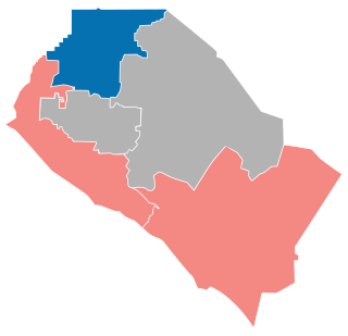
The 2018 Orange County Board of Supervisors elections was on June 5, 2018 as part of the primary election on June 5, 2018. Three of the five seats of the Orange County, California Board of Supervisors were up for election.
The Top of the World Reservoir, officially the Richard Jahraus Top of the World Reservoir is an artificial lake in Laguna Beach, California. Dedicated on October 27, 1996, it was named after J. Richard Jahraus, the current Director and President of the Laguna Beach County Water District at the Time. It has a capacity of 3,000,000 US gal (2,500,000 imp gal). Its main use is to supply water for authorities to fight against wildfires, with the high elevation allowing water circulation despite power outages. The lake is underground in a tank, below the Alta Laguna Park.

