
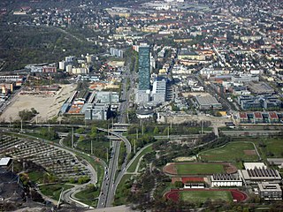
Milbertshofen, Am Riesenfeld and Am Hart are three boroughs situated in the north of Munich in Germany. Jointly, they form the city district 11 Milbertshofen-Am Hart. As of December 2016, the three boroughs had 76.255 inhabitants.

Schleißheimer Straße is the second longest street in Munich after Dachauer Straße with a length of 8.14 km. It starts in the city centre at Stiglmaierplatz, leads through five districts and ends at Goldschmiedplatz. It takes its name from the northern suburb of Oberschleißheim, where it originally ended.
Moosach[ˈmoːsax] is the 10th northwestern district of Munich, Bavaria, Germany. It is sectioned in the urban districts Hartmannshofen, Pressestadt and Borstei.
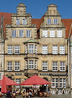
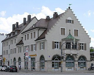
The Raths-Apotheke is a listed building on the Market Square (Marktplatz) in Bremen, Germany. After suffering war damage, the building was restored with two gables in the Neobaroque style in 1958, re-establishing the square's sequence of gabled buildings dating from the 1820s.

The Einkaufs-Center Neuperlach – pep is a shopping mall in Munich's Neuperlach borough operated by ECE. With a floor space of 60,000 square meters and about 135 specialty shops, it was according to a survey for the year 2002, the most profitable shopping center in Germany, the average revenue per square meter was twice as high as the national average. In designing the state capital, it is recognized as an integrated site with the function of a district center, and through its size has an important role for the entire southeast of the metropolitan Munich.

Am Riesenfeld is the westernmost of the three subdistricts of the Munich city district 11 Milbertshofen-Am Hart.

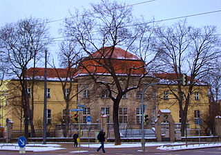
The Gymnasium München Nord is a Gymnasium in the Munich city district Milbertshofen-Am Hart. It has languages, mathematics and science specialisms and trains a quarter of its students at a national level in a competitive Olympic sport. The school is located at the former US army Alabama Depot area.
The Schwere-Reiter-Straße is a 1.2 km long street in Munich's Schwabing-West district in the Oberwiesenfeld area. It leads from Leonrodplatz to the Hohenzollernstraße on the corner of Winzererstraße, where it branches off to the north of the Ackermannstraße.

Hanauer Straße in Munich is an arterial road about one and a half kilometers long extending from south to north in the Moosach district. It was named after the Hesse city of Hanau.
The Landshuter Allee is an avenue in Munich and through most of its course it is part of the Mittlerer Ring, the Bundesstraße 2 R. It joins Donnersbergerbrücke at Arnulfstraße in the Neuhausen district and runs from Dachauer Straße west of the Olympiapark to Moosacher Straße west of the Olympic village in the Moosach district. The B 2R leaves the intersection-free avenue at the Landshuter Allee and continues on the Georg-Brauchle-Ring. The Landshuter Allee now functions as the B 304 and connects the Mittlerer Ring with the northern tangent of the Outer Ring, which is only partially complete. The large width of the Landshuter Allee of 54 metres between the houses is striking. It crosses the Nymphenburg-Biedersteiner Kanal.
Fürstenrieder Straße 255 is a residential and commercial building in Munich. It is registered as a historical building in the Bayerische Denkmalliste.

Fürstenrieder Straße 257 is a small residential and commercial building in Munich. It is registered as a historical building in the Bayerische Denkmalliste.

Anhalter Platz is a square in Munich's district 11 Milbertshofen-Am Hart in the district Am Riesenfeld.

The Petuelring is an approximately 2.2 km long road in the north of Munich and part of the Mittlerer Ring. It runs between Georg-Brauchle-Ring and Schenkendorfstraße.

Kurfürstenplatz is a square in the Munich district of Schwabing and is located about two and a half kilometres north of the city centre. It is the intersection of several streets and tram lines and was built in 1915 and named after the Elector Maximilian II. Emanuel, born in Munich in 1662.

Leonrodplatz is a square in the Munich district of Neuhausen. It was named in 1927 after the former Bavarian Minister of Justice Leopold von Leonrod.
The Brundageplatz is a square in the Munich Olympia Park in Milbertshofen-Am Hart.

The Platz der Freiheit is a Munich square at the intersection of Landshuter Allee / Leonrodstraße in the Neuhausen district.
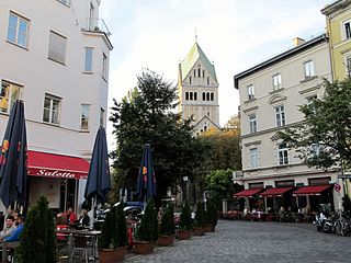
The St. Anna Platz is a square in Munich. It is registered as a listed ensemble in the Bayerische Denkmalliste.

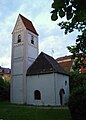 Alte St. Georgs Church
 No. 4: two-storey freestanding saddle roof, probably first half of the 19th century
 No. 5: two-storey freestanding saddle roof construction, approx. 1850

